Siepen (Marienheide)
|
Siepen
Municipality Marienheide
Coordinates: 51 ° 3 ′ 16 ″ N , 7 ° 34 ′ 25 ″ E
|
||
|---|---|---|
| Height : | 310 m above sea level NN | |
| Residents : | 23 (December 29, 2012) | |
| Postal code : | 51709 | |
| Area code : | 02261 | |
|
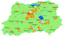
Location of Siepen in Marienheide |
||
Siepen is a village in Marienheide in the Oberbergischer Kreis in the administrative district of Cologne in North Rhine-Westphalia ( Germany ).
Location and description
The village is located on the southern edge of the municipality, about 5.5 km from the center of the main town. Siepen is located north of the Gummersbach district of Niedernhagen on the county road 46, which connects the federal road 256 (to the municipality capital Marienheide) with the state road 323 (Gummersbach - Meinerzhagen ), and on the Sieper Bach, a tributary to the Becke .
history
First mention
Around 1535 the place was mentioned for the first time in a document as “Das frauwen Guidt im Sipen” in a tax list.
The spelling of the first mention was Sipen .
The name of the place was probably transferred from a field name, which describes a humid valley in Bergisch (etymologically related to "sieve").
leisure
Hiking and biking trails
The A1 circular hiking trail , starting in Obernhagen, runs right past the village.
Bus and train connections
City bus 318
Stop: Niedernhagen

