Stülinghausen
|
Stülinghausen
Municipality Marienheide
Coordinates: 51 ° 4 ′ 14 " N , 7 ° 33 ′ 32" E
|
||
|---|---|---|
| Height : | 396 m | |
| Residents : | 228 (Nov. 24, 2005) | |
| Postal code : | 51709 | |
| Area code : | 02264 | |
|
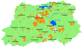
Location of Stülinghausen in Marienheide |
||
Stülinghausen is a village in the municipality of Marienheide in the Oberbergisches Kreis , North Rhine-Westphalia , Germany .
Location and description
The place is about 1.8 km from the main town, directly at the Brucher dam .
history
First mention
The place was mentioned for the first time in 1450 as a “privilege for an iron mine up dem Stuelinckhuesen broick”.
The spelling of the first mention was Stuelinckhuesen .
leisure
Association
- Stülinghausen village community
- Brucher dam sailing and canoeing community
Hiking and biking trails
The A7 circular hiking trail (Marienheide - Däinghausen - Kotthausen - Schöneborn - Späinghausen - Stülinghausen - Brucher dam - Eberg - Marienheide) leads through Späinghausen and is 9.6 kilometers in length.
Bus and train connections
Public buses
Stops: Stülinghausen and VdK-Heim
- 336 Direction: Rodt - Kalsbach - Gummersbach
- 336 Direction: Marienheide - Wipperfürth - Hückeswagen - RS-Lennep

