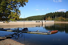
Brucher dam
| Brucher dam | |||||
|---|---|---|---|---|---|
| Aerial view of the Brucher Dam | |||||
|
|||||
|
|
|||||
| Coordinates | 51 ° 4 '52 " N , 7 ° 33' 27" E | ||||
| Data on the structure | |||||
| Construction time: | 1912-1913 | ||||
| Height above foundation level : | 27.5 m or 25 m | ||||
| Height above the river bed : | 21 m | ||||
| Building volume: | 28,000 m³ | ||||
| Crown length: | 200 m | ||||
| Crown width: | 4.5 m | ||||
| Data on the reservoir | |||||
| Altitude (at congestion destination ) | 369.77 m | ||||
| Water surface | 4.7 hectares | ||||
| Storage space | 3.38 million m³ | ||||
| Catchment area | 5.8 km² | ||||
| Design flood : | 14.5 m³ / s | ||||
The Brucher dam belongs to the municipality of Marienheide ( Oberbergischer Kreis ) in North Rhine-Westphalia and, in addition to flood regulation, serves to raise the low water level and provide local recreation; Campsites are available. The operator of the dam is the Wupperverband . The dammed body of water is the Brucher Bach . Water is also supplied from the Wipper through a 1280 m long tunnel to the west of Holzwipper . Active recreation such as sailing, swimming, boating, etc. is possible on the reservoir .
The Brucher Dam is best reached via the B 237 from Remscheid , the B 256 from the A 4 via Gummersbach or from the A 45 via the Meinerzhagen junction . Marienheide train station is two kilometers away.
The Brucher Dam, with which between 1912 and 1913 built from rubble stones according to the plans of Prof. Otto Intze , a 27.5 m (other information: 25 m) high weight dam with a crown width of 4.5 m and a length of 200 m , has a capacity of 3.38 million m³ and a surface of 47 hectares at maximum damming.
The dam, based on the Intze principle , was renovated and reinforced between 1990 and 1993 for 21 million DM. On the water side, a wall reinforcement with a cut-off wall, a separating layer and a drainage layer was concreted and a control corridor was installed. The dam was brought back to the state of the art .
On both sides of the dam was in the Second World War a Flak . Today, on one side, on a promontory, stands the DLRG water rescue station of the Bruch dam. On the other hand, the ruin is still there.
See also
Web links
- Dams directory NRW (PDF; 124 kB)
- Dams in North Rhine-Westphalia; State Environment Agency NRW (PDF; 124 kB)
- Wupperverband - Brucher dam


