Neuenhof (Marienheide)
|
Neuenhof
Municipality Marienheide
Coordinates: 51 ° 3 ′ 57 ″ N , 7 ° 30 ′ 49 ″ E
|
||
|---|---|---|
| Height : | 294 m | |
| Postal code : | 51709 | |
| Area code : | 02264 | |
|
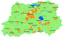
Location of Neuenhof in Marienheide |
||
Neuenhof is a former place of the municipality Marienheide in the Oberbergisches Kreis in North Rhine-Westphalia .
Location and description
Neuenhof is located in the southwest of Marienheide in the valley of the Mühlenbach on the L97 road (Leppestraße) on the edge of a new development area. In 2012 the place consists of two ponds, a former mill site and a rain overflow basin . Neighboring places are Winkel , Niederwette and Himmerkusen .
history
In the Prussian first recording from 1840, a mill symbol is recorded in the Neuenhof area. The mill is named "Höller Mühle". From the topographic map ( Prussian New Admission ) from 1894 to 1896, the place name is “Neuenhof”. In 1931 the mill symbol was last shown on a topographic map. The place name Neuenhof was used in the topographic maps until 1995.
bus connections
Neuenhof is connected to local public transport via the Wette and Niederwette stops on lines 308 and 399 (VRS / OVAG).

