Unterpentinghausen
|
Unterpentinghausen
Municipality Marienheide
Coordinates: 51 ° 3 ′ 34 " N , 7 ° 28 ′ 4" E
|
||
|---|---|---|
| Height : | 298 m | |
| Postal code : | 51709 | |
| Area code : | 02264 | |
|
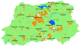
Location of Unterpentinghausen in Marienheide |
||
Unterpentinghausen is a district of the Marienheide community in the Oberbergisches Kreis in North Rhine-Westphalia .
Location and description
The place is located in the southwest of Marienheide on the border with the municipality of Lindlar near the village of Gimborn . Other neighboring towns are Kümmel and Eibach, which belongs to Lindlar .
history
In 1468 a miller from Pentekusen is mentioned in the invoice documents of the Steinbach office, who put the stable and barn in order. 1610 on the Waye map. In the Prussian first recording from 1840, the place is named "Nd. Pentinghausen ”recorded on topographic maps.
bus connections
Unterpentinghausen is connected to local public transport via the Gimborn branch of line 308 (VRS / OVAG).

