Reppinghausen
|
Reppinghausen
Municipality Marienheide
Coordinates: 51 ° 4 ′ 43 ″ N , 7 ° 32 ′ 21 ″ E
|
||
|---|---|---|
| Height : | 406 m | |
| Postal code : | 51709 | |
| Area code : | 02264 | |
|
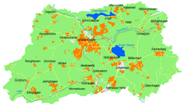
Location of Reppinghausen in Marienheide |
||
Reppinghausen is a place in the municipality of Marienheide in the Oberbergisches Kreis in North Rhine-Westphalia .
Location and description
The place Reppinghausen is now part of Marienheide and is located on the eastern outskirts of Marienheide. Neighboring towns are Eberg , Stülinghausen and Späinghausen . The Esternsiepen, which flows into the Leppe, rises in the southeast of the village .
history
Reppinghausen has been shown on topographical maps since the Prussian first recording in 1840. Since 1947 the topographical maps show the extent of Marienheide in the direction of Reppinghausen. In 1990 the place was already enclosed by the Marienheider town development.
bus connections
Reppinghausen is connected to local public transport via the bus stop for lines 320 and 336 (VRS / OVAG) in town.
Individual evidence
- ↑ Topographical Information Management TIM-online, provided by the Cologne District Government
- ↑ Wupperverband; River basin geographic information system
- ↑ Historika25, State Surveying Office NRW, sheet 4911, Gummersbach
- ↑ Busnetz 2010, Oberbergischer Kreis, published by Verkehrsverbund Rhein-Sieg GmbH

