Sattlershöhe
|
Sattlershöhe
Municipality Marienheide
Coordinates: 51 ° 5 ′ 23 " N , 7 ° 30 ′ 2" E
|
||
|---|---|---|
| Height : | 406 m | |
| Postal code : | 51709 | |
| Area code : | 02264 | |
|
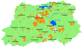
Location of Sattlershöhe in Marienheide |
||
Sattlershöhe is a place in the municipality of Marienheide in the Oberbergisches Kreis in North Rhine-Westphalia .
Location and description
Sattlershöhe is located in the west of Marienheide on the K13 district road. Neighboring places are Kempershöhe , Obergogarten Vorderscharde and Obersiemeringhausen . The Obergogartener Bach flows into the Wipper in the northeast of the village .
history
In 1715 the Topographia Ducatus Montani shows four courtyards and names them “Höh”. From the topographic map ( Prussian New Admission ) from 1894 to 1896, the place name is "Sattlershöhe".
bus connections
The 399 (VRS / OVAG) bus stop in the neighboring town of Kempershöhe is connected to the public transport system.
Individual evidence
- ↑ Topographical Information Management TIM-online, provided by the Cologne District Government
- ↑ Wupperverband; River basin geographic information system
- ↑ Historika25, State Surveying Office NRW, sheet 4911, Gummersbach
- ↑ Busnetz 2010, Oberbergischer Kreis, published by Verkehrsverbund Rhein-Sieg GmbH

