Mittelweg (Marienheide)
|
middle way
Municipality Marienheide
Coordinates: 51 ° 5 ′ 32 " N , 7 ° 28 ′ 58" E
|
||
|---|---|---|
| Height : | 393 m | |
| Postal code : | 51709 | |
| Area code : | 02264 | |
|
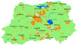
Location of Mittelweg in Marienheide |
||
Mittelweg is a place in the municipality of Marienheide in the Oberbergisches Kreis in North Rhine-Westphalia .
Location and description
Mittelweg is located in the west of Marienheide on the border with Wipperfürth . Neighboring places are Königsheide , Kempershöhe and Eiringhausen .
history
In 1825, the map Topographical Survey of the Rhineland shows an enclosed courtyard without a place name. To the north-west of it, a chapel is marked on the same map, which is named “Kap. Kohlbergshoh "is named. From the Prussian new admission from 1894 to 1896, the place is named Mittelweg.
hike
The hiking trail X19 - Schlösserweg signposted by SGV leads north of the village.

