Niedergogarten
|
Niedergogarten
Municipality Marienheide
Coordinates: 51 ° 6 ′ 3 ″ N , 7 ° 30 ′ 2 ″ E
|
||
|---|---|---|
| Height : | 311 m | |
| Postal code : | 51709 | |
| Area code : | 02264 | |
|
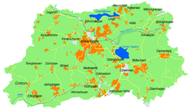
Location of Niedergogarten in Marienheide |
||
Niedergogarten is a former place of the municipality Marienheide in the Oberbergisches Kreis in North Rhine-Westphalia .
Location and description
Niedergogarten is located in the north-west of Marienheide in the Wipper valley on the B256 federal road . Neighboring places are Krommenohl , Kempershöhe and Sattlershöhe .
history
The map of Prussian first recording from 1840 shows a mill symbol marked with "EH" (iron hammer). In the topographic map ( Prussian New Admission ) from 1894 to 1896, the mill in Niedergogarten is marked as a factory. On the same map, a quarry and a dynamite factory are recorded for the first time in the southeast of the village . With the topographic map from 1947, the dynamite factory is no longer noted. The place name Niedergogarten was used in the topographic maps until 1984. On more recent maps, the place name is " Gogarten ".
With the expansion of the railway line via Wipperfürth to Marienheide in 1902, Niedergogarten received the “Gogarten” stop on the Wippertal Railway . Freight and passenger traffic ended with the cessation of rail operations on the Wipperfürth Ost and Marienheide section in 1985. A cycle path was laid on the route between Marienheide and Wipperfürth .
bus connections
Niedergogarten is connected to local public transport via the Gogarten stop on line 336 (VRS / OVAG) on the B256 federal road.

