Prussian first recording
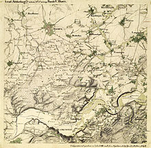
The Prussian first recording was a survey of Prussia that was carried out between 1830 and 1865. The result was the measuring table sheet , a set of maps on a scale of 1: 25,000 (4 cm = 1 km). The basis for the design was the "sample sheet for the topographical work of the royal Prussian general staff" from March 1, 1818. Since 1821, all the work of the land survey has been summarized under the chief of the general staff of the army, Karl von Müffling .
The cards get their name from the measuring table that was used for field work. Almost all maps were created by engineering geographers. The Prussian first recording served initially only to continue the Prussian General Staff Map , but it was carried out with improved recording procedures (more precise direction measurement), according to uniform rules and on a uniform scale of 1: 25,000. Embankment hatches were used to represent the terrain, from 1846 onwards contour lines were used .
It was not until 1868 that the maps were published in a monochrome edition, among other things by printing from the civilian side, which demanded these maps for better planning for road and railroad construction. The colored originals were in the German State Library in East Berlin until 1989 . Then they were transferred to the Prussian Cultural Heritage Foundation .
From 1875 the Prussian new admission took place .
See also
literature
- Georg Krauss: 150 years of Prussian measuring table sheets. In: Zeitschrift für Vermessungswesen , 94th year, 1969, issue 4, p. 125 ff, Konrad Wittwer Verlag, Stuttgart
- Peter Burggraaff: The Prussian first recording in the Rhineland and its significance for cultural landscape research. 1998

