Lambach (Marienheide)
|
Lambach
Municipality Marienheide
Coordinates: 51 ° 6 ′ 6 ″ N , 7 ° 33 ′ 14 ″ E
|
||
|---|---|---|
| Height : | 344 m | |
| Postal code : | 51709 | |
| Area code : | 02264 | |
|
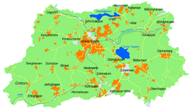
Location of Lambach in Marienheide |
||
Lambach is a district of the municipality of Marienheide in the Oberbergisches Kreis in North Rhine-Westphalia .
Location and description
The place is in the northeast of Marienheide on the Lingesetalsperre . The Benninghauser Bach flows past the eastern edge of the village and flows into the dam. There is a campsite on the western edge of the village. Neighboring towns are to be Kierspe belonging place Benninghausen and located in the municipality of Marienheide places Wernscheid and Linge .
history
In 1450 the place was first mentioned under the name "Langenbecke" in connection with the granting of a privilege for an iron mine in the Müllenbach parish .
hike
The local hiking trail A5 leads through Lambach.
bus connections
Lambach is connected to local public transport via the Kattwinkel / Wernscheid junction of line 399 (VRS / OVAG).
Individual evidence
- ↑ a b Topographical Information Management TIM-online, provided by the Cologne District Government
- ↑ Wupperverband; River basin geographic information system
- ^ Klaus Pampus: First documentary naming of Oberbergischer places (= contributions to Oberbergischen history. Sonderbd. 1). Oberbergische Department 1924 eV of the Bergisches Geschichtsverein, Gummersbach 1998, ISBN 3-88265-206-3 .
- ↑ Busnetz 2010, Oberbergischer Kreis, published by Verkehrsverbund Rhein-Sieg GmbH

