
Lingesetalsperre
| Lingesetalsperre | |||||||||
|---|---|---|---|---|---|---|---|---|---|
 |
|||||||||
|
|||||||||
|
|||||||||
| Coordinates | 51 ° 5 '57 " N , 7 ° 31' 53" E | ||||||||
| Data on the structure | |||||||||
| Construction time: | 1897-1899 | ||||||||
| Height above valley floor: | 20 m | ||||||||
| Height above foundation level : | 25.8 m | ||||||||
| Height of the structure crown: | 341.30 m | ||||||||
| Building volume: | 29,000 m³ | ||||||||
| Crown length: | 183 m | ||||||||
| Crown width: | 6.64 m | ||||||||
| Base width: | 16.70 m | ||||||||
| Radius of curvature : | 200 m | ||||||||
| Data on the reservoir | |||||||||
| Altitude (at congestion destination ) | 340.50 m | ||||||||
| Storage space | 2.6 million m³ | ||||||||
| Catchment area | 9.34 km² | ||||||||

Built between 1897 and 1899, the Lingesetalsperre is one of the oldest reservoirs owned by the Wupperverband . It is a small, manageable lake that was originally used to regulate the river and to supply industrial water. Today it is primarily used for leisure activities, flood protection and low water elevation. The dammed river is the Lingese, a tributary of the Wipper . The Lingese is the border river between Kierspe in the Sauerland and Marienheide in the Oberbergisches Kreis .
Barrier structure
The dam has an arch-shaped gravity dam made of quarry stone masonry of the Intze type as a barrier structure . The wall was renovated and reinforced from 1995 to 1998. She got a cut-off wall, a control passage and a drainage .
leisure
There are several campsites around the lake. There is also a restaurant. The Lingesetalsperre offers numerous water birds hidden breeding grounds. In addition to the wild ducks, water fowl, great crested grebes and gray herons , but also the kingfisher , can often be observed here. The fishing rights are to the sport fishing club of the upper Volme e. V. awarded.
photos
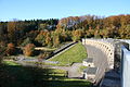
Airside view of the dam
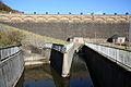
Flood overflow and bottom outlet

View from the water over the dam to the restoration


