Battle of Krefeld
| date | June 23, 1758 |
|---|---|
| place | Krefeld |
| output | Allied victory |
| Parties to the conflict | |
|---|---|
|
|
|
| Commander | |
| Troop strength | |
| 47,000 | 32,000 |
| losses | |
|
4,000 |
1,700 |
Western theater of war
Hastenbeck - Krefeld - Sandershausen - Lutterberg 1758 - Bergen - Minden - Gohfeld - Fulda - Korbach - Emsdorf - Warburg - Rhadern - Kampen Monastery - Langensalza - Saalfeld - Vellinghausen - Arnsberg - Wilhelmsthal - Lutterberg 1762
The Battle of Krefeld or the Battle of the Hückelsmay is a battle of the Seven Years' War that took place on June 23, 1758 between Allied and French troops. It represented a climax of the conflict in the Rhineland from 1756 to 1763.
Course of the battle
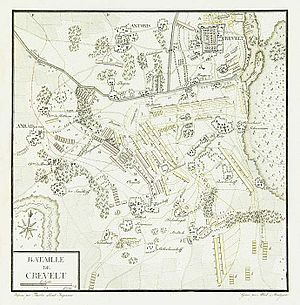
In the field at the Hückelsmay on the territory of modern forestry Forest , a district of Krefeld , met in the Seven Years' War on 23. June 1758 Allied troops under the command of Prince Ferdinand of Brunswick and a French army under the leadership of the Count of Clermont at the southern Outskirts of Krefeld together. The French stationed in Fischeln had already taken position with 47,000 men in front of the Landwehr at the passage near the Hückelsmay and expected an attack by Ferdinand from the north, who camped with a total of 32,000 men between Kempen and Hüls . Prince Ferdinand, however, ordered an attack from the south after the French positions had been bypassed via Vorst and Anrath . The French were taken by surprise by the Prince's army and forced eastwards into the pincers between the Landwehr in the north and a moat in the south, where they were wiped out. The French reserve was unable to achieve anything and, after heavy fighting with other mounted Prussian troops who intervened in the battle from the north via the Landwehr, had to retreat further east. In the late evening the battle was decided and the French withdrew for the time being via Osterath to Neuss .
Consequences and meaning of the battle
This battle near Krefeld went down in history. Despite their great superiority, the French were defeated. A month later, Prince Ferdinand moved part of his army to Roermond . At the end of June he had sent another to the siege of the Düsseldorf Fortress . Their French garrison capitulated on July 6, 1758, so that Prince Ferdinand could take Düsseldorf. He moved his headquarters to Dyck Castle near Jüchen . The army advanced to Grevenbroich and beyond. It only withdrew when the French, under their new commander, Louis-Georges-Erasme de Contades, came back from Cologne.
Prince Ferdinand left the city of Krefeld, which was now only defended by twelve Hanoverians, to the French. A memorial stone on the Hückelsmay still commemorates the 2,867 dead who are buried there and the 2,719 injured and captured soldiers from both parties.
To commemorate the victorious battle of the Hückelsmay, the Krefeld Prince Ferdinand von Braunschweig dedicated a street, the Prinz-Ferdinand-Straße .
In a room of the Hückelsmay country inn in Krefeld, right next to the former battlefield, the Forstwald Citizens' Association runs a small museum in which a diorama shows a section of the battle of the Hückelsmay on an area of around 10 m² .
In 1758 the Dutch cartographer Isaak Tirion made a map of the course of the battle on behalf of Friedrich von der Leyens .
literature
- Carl von Decker : The battles and main skirmishes of the Seven Years' War. With predominant reference to the use of artillery in connection with the other two main arms of the army . ES Mittler, Berlin, Posen and Bromberg 1837, p. 131-138 ( online ).
- EO Schmidt: Germany's battlefields . Fest'sche Verlagsbuchhandlung, Leipzig 1842, p. 125-128 ( online ).
- Christian HP von Westphalen: History of the campaigns of Duke Ferdinand of Braunschweig-Lüneberg . R. Decker, Berlin 1859, p. 159 ff . ( online ).
Web links
- DigAM Digital Archive Marburg: Plan of the Battle of Krefeld between the combined army of the British King under the Prince of Braunschweig-Lüneburg and the French under the Count of Clermont, June 23, 1758, with the camps before the battle
Coordinates: 51 ° 18 ′ 10 " N , 6 ° 30 ′ 39.3" E


