
Menzelen
|
Menzelen
Municipality of the Alps
|
|
|---|---|
 |
|
| Height : | 21 m |
| Area : | 13.05 km² |
| Residents : | 4068 (December 31, 2011) |
| Population density : | 312 inhabitants / km² |
| Incorporation : | 1st July 1969 |
| Postal code : | 46519 |
| Area code : | 02802 |
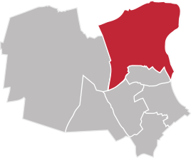  Location of Menzelen in the Alps
|
|
Menzelen is a district of the municipality of Alpen in North Rhine-Westphalia and is divided into Menzelen East and Menzelen West.
location
Menzelen is located 5 km north of the heart of the Alps. The Rhine flows east 4 km away, and the federal motorway 57 runs south 6 km away.
history
The first secure mention of Menzelens dates back to 1074 and can be found in a written document from Archbishop Anno II of Cologne . The oldest form of name for Menzelen is Masenzel here . In 1290 the parish church in Menzelen was mentioned for the first time in a document from the Xanten cathedral monastery. A baptismal font that stands today in the St. Walburgis Church, built in the 15th century, dates from around 1250. The Bailiwick of Menzelen came to the Archbishops of Cologne in 1388; since then Menzelen has belonged to the Rheinberg office . A school in Menzelen Ost was first mentioned in 1662. The building that houses today's primary school - the only school in Menzelen after the primary school in Menzelen West was closed in 1974 - was built before 1870 as a schoolhouse with a teacher's apartment. On July 1, 1969, as part of the first phase of the reorganization in North Rhine-Westphalia, the municipalities of Alpen, Menzelen and Veen merged to form the municipality of Alpen.
Population development
- 1954: 2552
- 1961: 2880
- 1969: 3046
- 2010: 4068
- 2016: 4100 (as of April 7, 2016)
politics
coat of arms
Blazon : A black cross in a silver (white) shield, topped with a golden (yellow) crown over an upright golden (yellow) scepter.
Meaning: Menzelen was formerly owned by the Electorate of Cologne and administered by the bailiff zu Rheinberg . That is why the coat of arms shows the black cross in silver, the coat of arms of the Archdiocese of Cologne . Crown and scepter are the attributes of the holy Walburgis , who came from royal blood. She is the patron saint of the church in Menzelen. The coat of arms was awarded to the former municipality of Menzelen on December 11, 1962.
Education and sport
In Menzelen there is a primary school and with the SV Menzelen 1925 a sports club with different sports. In addition, the Menzelenerheide 1879 rifle club, the Menzelen-Ost rifle brotherhood and the Menzelener model club 1976 are active in the town.
traffic
At the eastern edge of the district Menzelen-West, the federal road 57 ( Kleve - Rheinberg) crosses the area. With the bus lines 65 and 67 from DB Bahn Rheinlandbus there is a local transport connection to the Alps, Xanten , Rheinberg and Wesel .
Menzelen also had four train stations on three different routes. The first station went into operation in 1874 on the Haltern - Venlo line. This station was replaced in 1908 by the Menzelen East and Menzelen West stations . The latter went into operation in 1904 as a stop on the Rheinhausen - Kleve route and was expanded into a tower station in 1908 . Another station was located north of Menzelen on the Büderich - Gennep - Boxtel line , this Menzelen-Ginderich station was in operation from 1902 to 1945. The East and West (low) stations were operated by passengers until 1960, the upper part of the Westbahnhof was closed in 1978. Since then, Menzelen West has been exclusively a freight yard.
Web links
- History of Menzelen on the website of the Association for History and Customs Menzelen , accessed September 12, 2009
- Netzwerk-Menzelen.de is the website of the village workshop with current information on events and activities.
Individual evidence
- ↑ Martin Bünermann: The communities of the first reorganization program in North Rhine-Westphalia . Deutscher Gemeindeverlag, Cologne 1970, p. 103 .
- ↑ Martin Bünermann, Heinz Köstering: The communities and districts after the municipal territorial reform in North Rhine-Westphalia . Deutscher Gemeindeverlag, Cologne 1975, ISBN 3-555-30092-X , p. 223 .
- ↑ Figures, data and facts - the Alps are enthusiastic . In: The Alps inspire | Numbers, dates and facts . ( alpen.de [accessed October 19, 2017]).
- ↑ [1] ( Page no longer available , search in web archives ) Info: The link was automatically marked as defective. Please check the link according to the instructions and then remove this notice. Description of the coat of arms "History of the Moers District"
- ↑ Line map of the Wesel district on the left bank of the Rhine (back side). (PDF) Verkehrsverbund Rhein-Ruhr, accessed on December 21, 2014 .
- ^ Rolf Swoboda: Venlo Railway. Haltern - Wesel - Venlo . VBN Verlag Bernd Neddermeyer, Berlin 2010, ISBN 978-3-941712-04-1 , p. 106-111 .
- ^ Rolf Swoboda: Venlo Railway. Haltern - Wesel - Venlo . VBN Verlag Bernd Neddermeyer, Berlin 2010, ISBN 978-3-941712-04-1 , p. 316-319 .
