
Boenning
|
Boenning
Municipality of the Alps
Coordinates: 51 ° 35 ′ 42 " N , 6 ° 30 ′ 45" E
|
|
|---|---|
| Height : | 22.5 m |
| Area : | 1.98 km² |
| Residents : | 390 (December 31, 2010) |
| Population density : | 197 inhabitants / km² |
| Incorporation : | April 1, 1939 |
| Postal code : | 46519 |
| Area code : | 02802 |
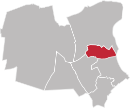  Location of Bönning in the Alps
|
|
Bönning is a district of the municipality of Alpen in North Rhine-Westphalia , statistically the place belongs to Menzelen .
location
Bönning is 4 km northeast of the heart of the Alps. The federal highway 57 runs south in a distance of 5 km.
history
Bönning, also known as Bönning-Rill together with the other small district of Rill , goes back to Franconian origins. The Loo house in Bönning was first mentioned in the 14th century. The building was right on the border with the glory of the Alps. On April 1, 1939, Bönning was incorporated into Menzelen. On July 1, 1969, as part of the first phase of the reorganization in North Rhine-Westphalia, the municipalities of Alpen, Menzelen and Veen merged to form the municipality of Alpen.
Population development
- 1910: 202
- 1931: 280
- 2010: approx. 390
Sports
In Bönning there is the citizens' rifle club of the St. Heinrich Schützenbruderschaft.
Individual evidence
- ^ History of the municipality of the Alps. Retrieved April 14, 2013 .
- ↑ Martin Bünermann: The communities of the first reorganization program in North Rhine-Westphalia . Deutscher Gemeindeverlag, Cologne 1970, p. 103 .
- ↑ Municipal directory 1910, Moers district. Retrieved April 14, 2013 .
- ^ GenWiki Amt Veen. Retrieved April 14, 2013 .
- ↑ Municipality of Alpen, population statistics according to localities according to the residents' registration office. (PDF; 156 kB) Retrieved April 14, 2013 .
