Giessener Südkreuz
| Giessener Südkreuz | |
|---|---|
|
|
|
| map | |
| location | |
| Country: | Germany |
| State : | Hesse |
| Coordinates: | 50 ° 31 '25 " N , 8 ° 38' 25" E |
| Height: | 178 m above sea level NN |
| Basic data | |
| Design type: | Shamrock |
| Bridges: | 1 (motorway) / 3 (other) |
| The Giessener Südkreuz from the air | |
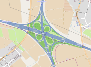
The Gießener Südkreuz is a motorway junction in Hessen near Gießen . It connects the federal highway 45 ( Sauerland line ; E 41 ) with the federal highway 485 ( Osttangente Gießen ).
geography
The motorway junction is mostly in the urban area of Linden in the district of Gießen , but parts of the southern ramps are also in the urban area of Hüttenberg in the Lahn-Dill district . The closest districts are Grossen-Linden (part of Linden), Hörnsheim (part of Hüttenberg) and Lützellinden (part of Gießen). It is located about 7 km south of Gießen , about 45 km north of Frankfurt am Main and about 10 km east of Wetzlar .
The Gießener Südkreuz has junction number 33 on the A 45 and number 9 on the A 485.
Design and state of development
Both motorways have four lanes in this area. All connecting ramps are single-track.
The motorway junction was laid out as a clover leaf .
Supraregional importance
As a connection between the A 45 and the A 5, the Gießener Südkreuz also handles important supra-regional traffic connections.
The highway A 4 from Olpe-south (link with the A 45 ) for Hattenbacher triangle (link with A 5 and A 7 ) in direct East-West axis in the center of Germany between the Rheinland and Thuringia across the Rothaargebirge was not built. The same applies to the now completely abandoned A 48 , which was to be connected as the Westerwald motorway via the Wetzlarer Kreuz to the Gießener Ring at the Reiskirchener Dreieck , but today ends near Montabaur at the Dernbach motorway triangle . Instead of the A 48 there are still plans to complete the route as the A 480 between the Wetzlarer Kreuz and the Wettenberg junction (Gießener Ring), so that there would be a continuous motorway between the A 45 and the A 5 for handling traffic relations; However, this is classified in the Federal Transport Infrastructure Plan as “further planning with a high ecological risk”, so that implementation can no longer be expected. Since the actual junction of the A 45 with the A 5, the Gambacher Kreuz , has no turning lanes for traffic from Dortmund / Wetzlar (A 45) in the direction of Kassel / Erfurt (A 5) and vice versa, road users must first take the A 45 Leave at Gießener Südkreuz and take the A 5 via the A 485 and A 480 to the Reiskirchener Dreieck.
Traffic volume
The cross is used by around 103,000 vehicles every day.
| From | To | Average daily traffic volume |
Share of heavy goods traffic |
|---|---|---|---|
| AS Gießen-Lützellinden (A 45) | Giessener Südkreuz | 61,900 | 15.4% |
| Giessener Südkreuz | Gambacher Kreuz (A 45) | 75,700 | 14.4% |
| AS Linden (A 485) | Giessener Südkreuz | 52,600 | 6.3% |
| Giessener Südkreuz | AS Langgöns (A 485) | 16,500 | 5.8% |
Individual evidence
- ^ Giessener Südkreuz. Motorway junctions and triangles in Germany, 2011, accessed on January 7, 2014 .
- ↑ Manual traffic census BAB 2015. (PDF) BASt Statistics, 2015, accessed on September 16, 2017 .

