List of listed objects in Ebenfurth
The list of listed objects in Ebenfurth contains the 8 listed immovable objects of the municipality of Ebenfurth in the Lower Austrian district of Wiener Neustadt-Land .
Monuments
| photo | monument | Location | description | Metadata |
|---|---|---|---|---|

|
Plague / Trinity Column ObjectID : 26601 |
Hauptstrasse location KG: Ebenfurth |
Erected in 1713 under Ferdinand Ignatius Unverzagt, three-zone, multi-figure structure over a triangular base |
ObjectID : 26601 Status: § 2a Status of the BDA list: 2020-02-29 Name: Pest- / Dreifaltigkeitssäule GstNr .: 1169/1 |

|
Residential house, former Johanniterkommende ObjektID : 26599 |
Heldenplatz 5 KG location : Ebenfurth |
Coming of the Order of St. John in the 13th century, one and a half-story building under a hipped roof, predominantly in the 2nd half of the 16th century, essentially much older, two-story building as early as the 13th century, additions from the 17th century |
ObjectID : 26599 Status : Notification Status of the BDA list: 2020-02-29 Name: Residential house, former Johanniterkommende GstNr .: 65/1 Johanniterkommende (Ebenfurth) |

|
Shrine Object ID: 26604 |
Rennbahnstraße location KG: Ebenfurth |
ObjectID : 26604 Status: § 2a Status of the BDA list: 2020-02-29 Name: Bildstock GstNr .: 1229 Bildstock Rennbahnstraße (Ebenfurth) |
|

|
Figure shrine St. Franz Xaver ObjectID : 26603 |
Schloßgasse location KG: Ebenfurth |
Inscribed 1853 (commemoration of the 300th anniversary of the saint's death), baroque (?) Wayside shrine, associated angel lost |
ObjectID : 26603 Status: § 2a Status of the BDA list: 2020-02-29 Name: Figurine picture stick hl. Franz Xaver GstNr .: 1171 Figure shrine St. Franz Xaver (Ebenfurth) |

|
Bürgerhaus ObjektID : 26597 |
Schloßgasse 7 KG location : Ebenfurth |
One-storey late Gothic building with a bay window and baroque stucco decoration over the windows |
ObjectID : 26597 Status : Notification Status of the BDA list: 2020-02-29 Name: Bürgerhaus GstNr .: 44/2 Bürgerhaus Schloßgasse (Ebenfurth) |

|
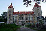
Ebenfurth Castle ObjectID : 26593 |
Schloßgasse 12 KG location : Ebenfurth |
Four-tower system, well-fortified moated castle from the 16th / 17th centuries Century, in the core 13th century (documented 1283), baroque in 1755 and defensive system removed, first system destroyed at the time of Ottokar II, under Konrad von Pottendorf new building 1293, 1495 to Heinrich Prueschenk, 1546–60 conversion to a Renaissance castle, under the Unverzagt family 1643–72 conversion to a baroque palace, 1747 to Leopold Gundacker von Suttner, construction of the palace chapel, from 1785 to the middle of the 19th century the Moser family |
ObjectID : 26593 Status : Notification Status of the BDA list: 2020-02-29 Name: Schloss Ebenfurth GstNr .: 1 Schloss Ebenfurth |

|
Complete system of city walls and gates ObjectID : 130054 |
KG location : Ebenfurth |
The 6-7 m high and 25 m long wall was built in the middle to the end of the 15th century. It contains the remains of a synagogue and the 17th century Annator, which is made of exposed brick and has a heraldic cartouche. Note: The coordinates refer to the annator |
ObjectID : 130054 Status : Notification Status of the BDA list: 2020-02-29 Name: Complete system of city wall and gates GstNr .: 2/2; 14; 17; 64; 65/1; 65/2; 66; 67; 68; 72/2; 72/3; 72/4; 281/1; 282; 283; 284; 288; 290; 292; 293; 364/1; 364/2; 364/3; 364/4; 376; 460; 461; 465/3; 470; 1169/1; 1170; 1171; 1172; 1175/14; 1177/1; 281/2 city wall (Ebenfurth) |

|
Wiener Neustädter Canal ObjectID : 117222 |
Location KG: Haschendorf |
The Wiener Neustädter Canal was put into operation in 1803 and extended up to 63 km. Originally it was planned as far as Trieste . Parts of the route were later converted to railway lines, so that the movement of goods fell sharply from 1879 onwards. |
ObjectID : 117222 Status : Notification Status of the BDA list: 2020-02-29 Name: Wiener Neustädter Kanal GstNr .: 383/1; 383/2; 383/3; 386/11; 594/2; 595/2 |
Web links
Commons : Listed objects in Ebenfurth - collection of images, videos and audio files
Individual evidence
- ↑ a b Lower Austria - immovable and archaeological monuments under monument protection. (PDF), ( CSV ). Federal Monuments Office , as of February 14, 2020.
- ↑ § 2a Monument Protection Act in the legal information system of the Republic of Austria .
