
Elderly food
|
Altenessen |
|

|
|
| Basic data | |
|---|---|
| surface | 11.4 km² |
| Residents | 44,203 (March 31, 2020) |
| Coordinates | 51 ° 29 '47 " N , 7 ° 0' 33" E |
| height | 42 m |
| Incorporation | Apr 1, 1915 |
| Spatial assignment | |
| Post Code | 45326, 45329 |
| District number | 24/25 |
| district | District V Altenessen / Karnap / Vogelheim |
| image | |
![Allee-Center, opened as Altenessen shopping center on November 2, 1973 [1]](https://de.wikipedia.org/wiki/Datei:AltenessenAllecenter.jpg) Allee-Center , opened as Altenessen shopping center on November 2, 1973 |
|
| Source: City of Essen statistics | |
Altenessen is a northern part of the city of Essen . Since its incorporation, it has been officially divided into the two districts of Altenessen-Süd and Altenessen-Nord due to its size . Taken together, Altenessen would be the most populous district in Essen. It borders the Vogelheim and Bochold districts in the west, the north quarter in the south, Katernberg and Stoppenberg in the east and Karnap in the north, with the Emscher and the parallel Rhine-Herne Canal forming the border here.
history
Early history
During the construction of a coking plant for what was then the Helene colliery , early medieval graves were recovered in 1876. At least four burials from the 7th to the early 8th century AD have survived. During subsequent excavations in 1982 after the colliery was closed, no further remains of this cemetery were found.
For the first time, the terms Alden Essende or Aldenessende appear from 1120 in addition to the actual meal. The demarcation of Altenessen and Essen was first recorded in a document on December 7, 1310.
Altenessen was on the Strata Coloniensis , one of the five old streets from the early Middle Ages that connected Cologne with the surrounding area. It ran roughly on today's Altenessener Strasse. A village core could not develop.
Affiliations
On September 1, 1808 in by Napoleon erected Mountain Grand Duchy of the municipality formed Altenessen, in addition to the former peasantry Altenessen also Frillendorf , Huttrop , Karnap , Schonnebeck , Katerberg , Kray , Leithe , Rotthausen , Ruettenscheid and Stoppenberg belonged. In 1813 the municipality of Altenessen became an independent mayor's office under the Prussians , which gained further importance through industrialization due to the booming coal mining industry from around 1840. From January 1, 1874, the Altenessen mayor's office belonged only to Karnap, all other parts went to the new Stoppenberg mayor's office. This mayor's office in Altenessen existed until Altenessen was incorporated into the city of Essen on April 1, 1915, with Karnap remaining independent until 1929.
The municipality and mayor of Altenessen had eight mayors from 1808 until the incorporation in 1915:
- 1808–1811: Bernhard Radhoff
- 1811–1815: Johannes Alois Theodor Nienhausen
- 1815-1834: Christian Noot
- 1834–1840: Bertram Pfeiffer
- 1840–1844: Samuel Friedrich Biegon von Czudnochowski
- 1844–1868: Friedrich de Wolff
- 1868–1886: Ernst Péan
- 1886–1915: Theodor Stankeit
Industrialization and the consequences
In 1847 the Altenessen station was opened on the Cologne-Mindener Eisenbahn , which was Essen's most important station until the Essen main station opened in 1862. This was followed by a disorderly development in Altenessen, because outside of the previous settlement areas, coal mines such as the Anna colliery (1851), the Fritz-Heinrich colliery (1859), the Carl colliery (1855) and the United Helene & Amalie colliery (1873) were built. The need for work, also at supplier companies, ancillary industries and retail trade, was followed by the immigration of workers and thus a rapidly increasing population. In 1812 there were 556 inhabitants, in 1845 already 960 and in 1915 over 45,000 inhabitants. The growth of Altenessen did not emerge from a settlement core, but spread out near the scattered collieries.
The volunteer fire brigade was founded in Altenessen-Nord in 1860 and remained in operation until 1894. The Spritzenhaus stood in today's Spritzenstrasse, which was named after it in 1903. On August 30, 1895, the voluntary fire brigade was re-established at the instigation of the government in Düsseldorf. In 1912, the Altenessen mayor's office built a new fire department depot on Grünstraße, which was built at the time. At that time it was still on the green field, one also said Bruchland.
In 1893 the tram line between Altenessen and Essen city center was completed. For the 100th birthday of Kaiser Wilhelm I , the Kaiser Wilhelm Park was opened on March 21, 1897 .
With the closure of the Emil-Fritz mine in the early 1970s, coal mining in Altenessen ended. This meant that the last industrial jobs in the district were lost, which resulted in a structural change. In former colliery buildings and partly on brownfield sites, new cultural and sports facilities were created. Cycle paths were partly laid out on disused railway lines.
coat of arms

Blazon : "In blue over two right-angled opposing silver (white) ash branches an oblique-left golden (yellow) sword."
Meaning: The coat of arms alludes to the old name of Essen Asnide , which in some traditions is also derived from "ash". The blue shield and the sword make the reference to the Essen city coat of arms.
population
On March 31, 2020, there were 44,203 residents in Altenessen. 16,977 of them lived in Altenessen-Nord and 27,226 in Altenessen-Süd.
Altenessen-Nord
Structural data of the population in Altenessen-Nord (as of March 31, 2020):
- Proportion of the population under 18 years of age: 19.0% (Essen average: 16.2%)
- Population of at least 65-year-olds: 19.4% (Essen average: 21.5%)
- Proportion of foreigners: 20.5% (Essen average: 16.9%)
Altenessen-Süd
Structural data of the population in Altenessen-Süd (as of March 31, 2020):
- Proportion of the population under 18-year-olds: 19.6% (Essen average: 16.2%)
- Population of at least 65-year-olds: 17.4% (Essen average: 21.5%)
- Proportion of foreigners: 27.4% (Essen average: 16.9%)
traffic
The federal road 224 runs in a north-south direction through Altenessen and has a connection to the federal freeway 42 at the Essen-Nord junction . Another eastern exit of the A 42 is called Essen-Altenessen.
The Essen-Altenessen regional train station belongs to Altenessen .
Local public transport ( ÖPNV ) was fundamentally rebuilt in the 1990s . Currently elderly food is through the rail lines U11 (Ge-Buerer Straße- Fair / Gruga ) and U17 (Karl-seat Margarethenhoehe) as well as by the tramline (all driven by the 108 (Altenessen Bf-Bredeney) Ruhr path ) of the center of Essen achieved. In addition to the trams, the bus routes 140, 170, 162, 172, 173 and 183 also run in Altenessen. In addition to the train station, there are also the Altenessen Mitte and Karlsplatz underground stations .
Sports
The football clubs SV Altenessen , BV Altenessen 06 and TuS Helene Essen are primarily of historical importance . The latter is located in the Bäuminghausstrasse district sports facility .
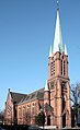
photos

Former Altenessen town hall around 1925
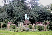
Monument in the Kaiser Wilhelm Park
Evangelical Old Church

Catholic Sacred Heart Church

Catholic Church of St. Hedwig


See also
- List of architectural monuments in Altenessen-Nord
- List of architectural monuments in Altenessen-Süd
Web links
- Interest group Altenessen eV
- altenessen.info, private information portal
- District portrait on the homepage of the city of Essen
Individual evidence
- ↑ Stadtspiegel of September 3, 2008; 35 years of Allee-Center
- ↑ Bonner Jahrbücher 64, 1878, 191f. - Frauke Stein : Noble graves of the eighth century in Germany. Germanic Monuments of the Migration Period Series A Volume 9. Berlin 1967, p. 306f., Pl. 44.1. - Frank Siegmund: Merovingian period on the Lower Rhine. Rhenish excavations 34. Rheinland-Verlag, Cologne 1998, 272f.
- ↑ Bonner Jahrbücher 185, 1985, 487
- ^ Westdeutsche Allgemeine Zeitung WAZ v. August 23, 2008 - Essen regional section
- ↑ See on this Johann Rainer Busch: Kurt Schweders coat of arms of the Essen districts . Essen 2009, p. 78.
- ↑ Population figures of the districts
- ↑ Proportion of the population under 18 years of age
- ↑ Proportion of the population aged 65 and over
- ↑ Proportion of foreigners in the city districts
- ↑ Proportion of the population under 18 years of age
- ↑ Proportion of the population aged 65 and over
- ↑ Proportion of foreigners in the city districts
- ^ Ruhrbahn

District I: city center | East Quarter | North Quarter | West Quarter | Südviertel | Southeast Quarter | Huttrop | Frillendorf | District II: Bergerhausen | Rellinghausen | Rüttenscheid | City forest | District III: Altendorf | Frohnhausen | Fulerum | Pigtail | Holsterhausen | Margarethenhöhe | District IV: Condition levels | Bergeborbeck | Bochold | Borbeck-Mitte | Dellwig | Frintrop | Gerschede | Schönebeck | District V: Altenessen | Karnap | Bird home | District VI: Katernberg | Schonnebeck | Stoppenberg | District VII: Freisenbruch | Horst | Kray | Leithe | Steele | District VIII: Burgaltendorf | Byfang | Heisingen | Copper turning | Überruhr | District IX: Bredeney | Fish sheet | Heidhausen | Kettwig | Schuir | Become