
Old Kölnische Landstrasse
As Alte Kölnische Strasse or Alte Kölnische Landstrasse , several old streets are referred to, which, starting from Cologne, led to the north and northeast as trade and military routes on the right bank of the Rhine. In addition to the Mauspfad , Heidenstraße , Brüderstraße , Heerweg Köln – Wipperfürth – Soest and Heerweg Köln – Dortmund, the early medieval long-distance road Strata Coloniensis , hereinafter also referred to as Alte Kölnische Straße (Trasse 3), is one of the most important streets on the right bank of the Rhine Connected Cologne with the surrounding area.
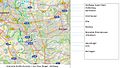
(The numbers in brackets indicate the individual streets in the map sections)
Old streets on the left bank of the Rhine in the Cologne area

In the Middle Ages , most of the goods traffic coming from Cologne was transported to the north on the left bank of the Rhine on the well-developed Roman roads (6). The paved Roman road led along the banks of the old Rhine from Cologne via Dormagen to the Zons Fortress and further on the left bank of the Rhine via Neuss , Mülfort (near Mönchengladbach), Rheindahlen to Roermond .
At the Feste Zons, the Roman road crossed a south-northeast connection (7). This south-northeast connection led from Jülich or Düren via Rommerskirchen , Anstel , Knechtsteden monastery , Horrem to Zons and from there to the Rhine crossing at the former Roman fort Haus Bürgel . In the early Middle Ages, Haus Bürgel was on the left bank of the Rhine. During a devastating Rhine flood at the end of the 14th century (possibly in 1374), the river bed shifted to the west and the estate has since been on the right instead of the left of the Rhine and is now separated from Zons by the Rhine.
Old streets on the right bank of the Rhine coming from Cologne
.jpg)
Given the great economic importance of the city of Cologne, trade routes on the right bank of the Rhine also served the traffic of goods from Cologne to the north and north-east in the Middle Ages. Cologne obtained primarily agricultural products from Niederberg and Westphalia , but also raw hides . Cologne delivered wine, cloth and leather to Westphalia. Cologne had an important leather trade and in the 16th century it took first place in German silk production.
While linksrheinisch still the old road network of well-built Roman roads could be used for traffic, there was rechtsrheinisch mostly unpaved, narrow and muddy dirt roads with deep, from the carts caused ruts . Some of them were reinforced with sticks, rods or braids, but they were difficult to use with shopping carts.
The five streets that were called Kölnische Strasse or Kölner Strasse in the literature are numbered here from east to west. They ran north or north-east through the Niederberg area to Westphalia. The oldest and best known was the Strata Coloniensis , Kölnische Strasse Trasse 3.
Kölnische Strasse route 1
Kölnische Strasse Trasse 1 (1) ran on the right bank of the Rhine closest to the river. It ran parallel to the mouse path (8) and crossed it at Ratingen and Duisburg. The main difference between the two traffic routes is that Kölnische Strasse Trasse 1, coming from Cologne via Zons, crossed the Rhine at Haus Bürgel. In contrast, the Mauspfad ran some distance to the right of the Rhine in the Cologne area and never crossed it.
The Kölnische Strasse Trasse 1 from Haus Bürgel to Düsseldorf-Nord
From Haus Bürgel, Kölnische Strasse Trasse 1 ran along the Rhine via Urdenbach , the Benrath Rhine Plain, Reisholz to Haus Eller . From there it led in a straight line to the north on the lower terrace on the right bank of the Rhine . First it went via today's Düsseldorf districts of Eller , Vennhausen , Gerresheim , Grafenberg to the high terrace of the Aaper forest in Wolfsaap .
The Kölnische Strasse Trasse 1 from Düsseldorf-Nord via Ratingen to Mülheim (Ruhr), Duissern
The Kölnische Strasse Trasse 1 crossed the Schwarzbach at Hof Mühlentaler and reached Ratingen at the Düsseldorfer Tor. There she cut the mouse path for the first time in the market square. After crossing over the Anger , Kölnische Strasse Trasse 1 led through the area of today's Blue Lake .
On its way north, it ran via Schwarzenbruch , Trockener Stiefel , Kost, Krummenweg past the Breitscheider Hof to Selbeck ( Mülheim an der Ruhr ) and on to the Cistercian monastery in Mülheim-Saarn . From there it went over the Saarner Berg and through the Duisburg Forest past Wolfsberg in the direction of Duisserner Berg ( Kaiserberg ) to Duissern , today a district of Duisburg . In Duissern, Kölnische Strasse Trasse 1 reached the mouse path for the second time. Duissern was also on the Westphalian Hellweg (11) the old Franconian Heerweg, which, coming from the east, led to the confluence of the Ruhr with the Rhine.
The end of Kölnische Straße Trasse 1 can be seen at the transshipment point of the country roads with the Rhine in the area of Duisburg's old town. There the goods were loaded onto ships and transported on the Rhine more conveniently and safely.
Kölnische Strasse route 2
Kölnische Strasse Trasse 2 (2) ran between Kölnische Strasse Trasse 1 and Kölnische Strasse Trasse 3, the Strata Coloniensis , and did not take the terrain profile into account. As it went up and downhill, it had been used more as a bridle path than by carts.
The Kölnische Strasse Trasse 2 from Haus Bürgel to Erkrath
After the crossing over the Rhine at Haus Bürgel, Kölnische Strasse Trasse 2 ran in the direction of Urdenbach over the Paulsmühle at today's Benrath Castle , to Elb near Hilden . At the Rohrsmühle she met the mouse path and continued to Ten-Ofen north of the Unterbach house .
In today's Mettmann district , it climbed to the Heiligenhäuschen on the Korresberg ( 103 m above sea level ) and then descended again in Erkrath past the Catholic church ( 60 m above sea level ). After the Düssel brook was crossed, it rose again on the other side of the Düssel zu Gans valley . There it intersected with today's Laubacher Strasse, which leads to Mettmann.
The Kölnische Straße Trasse 2 from Erkrath to Velbert

Coming from Erkrath, the Kölnische Strasse Trasse 2 went on to the Stindermühle ( 113 m above sea level ) in the Stinderbachtal , in order to then climb to the highest point in the western regions of the Niederbergisches Land, the Kißberg ( 142 m above sea level ). At Lindchen , near what is now the Höhne estate , it intersected Bergische Landstrasse (10) (now Bundesstrasse 7 ), which leads in the direction of Mettmann.
The route from Kraumenhaus , east of Hassel and the descent to the Papsthof was difficult to rediscover for the researchers of Kölnische Strasse Trasse 2. From the Papsthof the path rose to the Hoferhäuschen ( 147 m above sea level ). Here she reached the Ratingen – Hassel road. The Kölnische Straße Trasse 2 ran along the ridge via Rosenthal ( 131 m above sea level ) to climb to Hof Flicken ( 155 m above sea level ). Then she descended into the Schwarzbachtal to cross the river at the Schwarzbachhof north of Metzkausen . On the other side of the Schwarzbach valley, the ascent to Gut Zehnthof was east of Meiersberg . There she cut the road from Ratingen to Wülfrath .
After crossing the Anger stream at Hof In der Laubeck , east of the Hofermühle , the path led to the Henriettenhof south of Heiligenhaus and further north. At Dalbecksbaum, west of Velbert , the transition to Kölnische Strasse was Trasse 3, the Strata Coloniensis
The Strata Coloniensis , Kölnische Strasse Trasse 3
The middle of the five Kölnische Strasse was Kölnische Strasse Trasse 3 (3), known in literature as Strata Coloniensis . The Strata Coloniensis was one of the most important long-distance trade routes in the Niederberg hills in the Middle Ages . It connected the trading metropolis of Cologne with the 799 from St. Liudger founded the empire-free Werden Abbey , later a Benedictine monastery. When Altfrid , the 4th Bishop of Hildesheim , founded a free world monastery for high nobility ladies on his Astnide estate at the intersection of Hellweg and Strata Coloniensis in 852 , the foundation stone of the city of Essen was laid.
The Strata Coloniensis was a traffic route coming from Cologne that already existed at the beginning of the 2nd century. The first evidence is a deed of donation: On October 16, 1065, Heinrich IV gave the Archbishop of Bremen a forest spell between the Ruhr, Rhine, Düssel and the path that leads from Cologne to the bridge before Werden . In the Middle Ages, several merchants joined forces and went together as a trek . They received military protection from the Archbishop in Cologne to accompany them against robbers, for this reason the trade routes were also called protective roads.
Coming from Cologne, the Strata Coloniensis ran on the left bank of the Rhine via Dormagen on old, well-paved Roman roads (6) to Zons. There she changed to the right bank of the Rhine near the Old Rhine and ran to the Haus Bürgel fort. There the Kölnische Strasse Trasse 1 and Kölnische Strasse Trasse 3 branched out.
The Strata Coloniensis from Haus Bürgel via Hilden, Hochdahl to Mettmann

The course of the Strata Coloniensis led on the right bank of the Rhine as a trade route, protective and military road from Haus Bürgel via Hellerhof near Garath , past Buchholz, Haus Horst , Horster Allee to Itterbach and along the flowing water to Hilden.
The Strata Coloniensis crossed the mouse path (8) ( Gerresheimer Strasse , Schwanenstrasse , Schulstrasse , Richrather Strasse ) in Hilden near the Reformation Church and the former Hohen Hof, Fronhof . In order not to have to go through the center of Hilden during wartime, the Heerstraße street was used as a cross connection between the Mauspfad ( Gerresheimer Straße ) and the Strata Coloniensis ( Benrather Straße ). You crossed Hilden on today's Mittelstraße to the fork and turned into Hochdahler Straße . We went on to today's Landgasthaus Kemperdick, where the Hühnerbach and the Mahnerter Bach flow together and form the Eselsbach , past Stocks and Klockes Busch to Hochdahl-Trills .
At Trills, the Kölnische Strasse Trasse 4 branched off from the Strata Coloniensis to the north-east in the direction of Millrath . The local history researcher Klockenhoff wrote: “ In Hochdahl-Millrath, a junction from the Strata is known as Alte Kölner Straße. Your fork must have been between Trillser - and Böllenschmiedts Hof, about at the level of Sedentaler Straße ”.
In Trills, the Strata Coloniensis ran east past the Schlickum estate , which is in front of the Clef estate . Then she climbed the steep mountain to the Hochdahler Höhe in the direction of today's Hochdahl train station. She descended via Hof Thekhaus into the valley of the Düssel and crossed the river at the confluence of the Mettmanner Bach at the foot of the Butterberg .
After climbing towards the Neanderthal train station , she passed the Eidamshaus and continued on the Höhenstraße to Mettmann.
The Strata Coloniensis from Mettmann to Essen-Werden
From Mettmann, the northern Strata Coloniensis led along the Bibelskircher Weg to Hoferneuhaus . At Siepen , northwest of Wülfrath, it crossed the Anger brook and crossed the Altstrasse Frankfurter Strasse (9). To the west of Velbert she passed Tillmannshöfen and Velbert- Dalbecksbaum . There it was also merged with Kölnische Strasse Trasse 2. Through Wordenbeck and Plätze near Velbert it reached the Ruhr crossing near Werden . There was the end of the Strata Coloniensis .
The route continued north via Essen , Altenessen and Münster to Lübeck . In Essen, the Strata Coloniensis crossed the west-east connection Westfälischer Hellweg.
The Kölnische Strasse route 4

Kölnische Strasse Trasse 4 (4) was a connecting road between the old streets Strata Coloniensis (3) and Frankfurter Strasse (9). At Trills it branched off from Kölnische Strasse Trasse 3, Strata Coloniensis , to the north-east. The Kölnische Straße Trasse 4 ran via Schlickum, Millrath, Gut Thunis , Thunisbrücke , Winkelsmühle , Steinöckel homestead , Potherbruch to Hahnenfurth . There it crossed Bergische Landstrasse (10) and after Schöllersheide near Wülfrath- Düssel, it met Frankfurter Strasse (9).
The Kölnische Strasse route 5

The Kölnische Strasse Trasse 5 (5) branched off from the Strata Coloniensis at the Bürgel building . It ran through the Urdenbacher Kämpe via Hellerhof near Garath, in the south of Hilden past Karnap and Haus Tillmann, through the Hildener Kölner Straße with the Wiedenhof to Forstbach , Pungshaus next to the Holterhöfchen . The Pungshausstraße led to Kalstert , through today's A3 motorway underpass to the Wirtz farm. The route 5 then passed south of the Jaberg and ended in the east of Kalstert in today's Ohligser Strasse, the eastern connecting road between Hilden-Ost and Haan. After a short stretch, she followed the stream northeast along the Hülsberger Busch and Haaner Kölner Strasse .
In the vicinity of the Catholic Church of St. Chrysanthus and Daria (Haan) in Haan , she walked east for a short distance on what is now the 228 federal highway , and then branched off to Graefrath . In Gräfrath, route 5 swiveled north towards Vohwinkel and on to Sonnborn . In the Vohwinkeler Senke in Sonnborn, it met today's L74 on Frankfurter Altstrasse , which came from the south via Cronenberg .
In Hilden, Dorfstraße / Mittelstraße was the connection between the old streets Strata Coloniensis and the Mauspfad, both of which led past the Protestant church ( Reformation Church ), and Kölnische Straße Trasse 5. The connection ended on the lower Walder Straße at the level of the western Kalstert (today motorway underpass) into route 5.
Cards (after Erich Krumme)
Kölnische Strasse Trasse 1, south: House Bürgel - Wolfsaap

Kölnische Strasse Trasse 1, north: Wolfsaap - Duisburg

Kölnische Strasse Trasse 2, south: House Bürgel - Erkrath

Kölnische Strasse Trasse 2, north: Erkrath - Velbert

Kölnische Strasse / Strata Coloniensis Trasse 3, south: House Bürgel - Mettmann

Kölnische Strasse / Strata Coloniensis Trasse 3, north: Mettmann - Werden

Kölnische Strasse route 4: Trills - Wülfrath-Düssel

Kölnische Strasse route 5: House Bürgel - Hilden - Haan - Vohwinkel
.jpg)
.jpg)
.jpg)
.jpg)
.jpg)

.jpg)
.jpg)
Individual evidence
- ↑ a b c d e f g h i j k l m n o p q Erich Krumme: The Cologne streets in the Niederberg area. In: Romerike Berge. Journal for home care in the Bergisches Land. 11th year 1961/62 issue 2, pp. 68-80.
- ↑ a b c d e f g h openstreetmap as a background for the course of the Cologne streets
- ↑ The mouse path with its old settlement areas. In: Journal No. 10, p. 76.
- ↑ a b Stefan Pätzpold: Welcome guests or dangerous crooks? 'Strangers' in Essen, Bochum and Dortmund during the late Middle Ages.
- ↑ City tour of Essen
- ↑ Hanna Eggerath: The "Strata Coloniensis" from Werden to Hilden. In: Journal 12, 1992/1993, pp. 23,27.
- ^ Theodor Joseph Lacomblet : Document book for the history of the Lower Rhine. Volume 1, p. 133.
- ^ A b Anton Schneider: Contributions to the history of Hilden and Haan. Hilden City Archives, 1900, pp. 13-14.
- ↑ a b The "Strata Coloniensis" in Hochdahl - on the trail of an old street.
- ↑ a b Helmut Kreil: The "Strata Coloniensis" and Mettmann.
literature
- Erich Krumme: The mouse path between the Ruhr and the Itter and its parallel streets. In: Romerike Berge. Journal for home care in the Bergisches Land. 10 (1960-1961), pp. 145-158.
- Erich Krumme: Old connecting roads in the interior of the Niederberg area. In: Romerike Berge. Journal for home care in the Bergisches Land. 14 (1964/65), pp. 29-40.
- Theodor Josef Lacomblet : Document book for the history of the Lower Rhine: evidence of tradition . Self-published d. NW State Archives, 1981 ( limited preview in Google Book search).
- Hanna Eggerath: Erkrath: Unterbach, Unterfeldhaus, Hochdahl, Neandertal. Sutton Verlag, 1998, ISBN 3-89702-038-6 .
- Karl Klockenhoff: Around the Neandertal. Verlag Hermann Michael, Mettmann 1967, p. 35. (Quoted from: F. Körholz - Bergische Heimat 5/1931, p. 116)
- Hermann Bannitza: Prehistoric sites in Haan (Rhineland). Selbstverlag, Haan 1986, p. 162 f, p. 180-183.