
Schwarzbach (Rhine, Wittlaer)
| Schwarzbach | ||
 The Schwarzbach in winter |
||
| Data | ||
| Water code | EN : 2754 | |
| location | North Rhine-Westphalia | |
| River system | Rhine | |
| Drain over | Rhine → North Sea | |
| source | in Mettmann near Obschwarzbach on the border with Wülfrath 51 ° 17 ′ 2 ″ N , 7 ° 0 ′ 17 ″ E |
|
| muzzle | in Düsseldorf-Wittlaer in the Rhine Coordinates: 51 ° 19 ′ 20 ″ N , 6 ° 44 ′ 6 ″ E 51 ° 19 ′ 20 ″ N , 6 ° 44 ′ 6 ″ E
|
|
| length | 27.3 km | |
| Catchment area | 54.983 km² | |
| Left tributaries | Kötelssiepener Bach , Meisenburgbach , Flickerbach , Krumbach , Hasselbach , Schönheitsbach , Römersgraben | |
| Right tributaries | Hausmannsgraben , Artzbergbach , Steinhauser Bach , Brachter Bach , Haarbach | |
| Big cities | Dusseldorf | |
| Medium-sized cities | Mettmann , Ratingen | |
The Schwarzbach is a brook in the Bergisches Land in North Rhine-Westphalia . It rises in the Mettmann area right on the border with Wülfrath and flows through Ratingen and Düsseldorf into the Rhine .
The stream is about 27 km long and has a catchment area of 55 km². It has the water quality class II (moderately polluted). Its fish population consists of brown trout , rainbow trout , char , perch , roach / feathers , carp , pike , catfish and pikeperch .
In Ratingen, as a largely natural stream, it crosses two nature reserves and a landscape protection area . Between Ratingen and Düsseldorf, its course was more humanly influenced by sand mining and the remaining quarry ponds , Düsseldorf Airport and the Düsseldorf-Nord motorway junction . North of the airport, it is connected to the Kittelbach by a ditch . In Düsseldorf-Kalkum it flows through the park of the palace before it reaches its confluence with the Rhine in Düsseldorf-Wittlaer .
The stream is the namesake of some geographical objects. In his Mettmann headwaters, the districts that emerged from the former Obschwarzbach and Niederschwarzbach districts are named after him, in Ratingen the Schwarzbachtal and the nature reserve of the same name near the Götzenberg estate east of the city as well as the Schwarzbach district and the junction 33 of the federal motorway 44 named after it . The Schwarzbachtalbrücke of the federal motorway 3 crosses it east of Ratingen .

Schwarzbach in the south of the Volkardey recreation park in Ratingen (2012)

Wooden bridge near Kalkum in winter (2018)

The Schwarzbach in the castle park, channeled through Weyhe (2014)
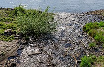
Confluence with the Rhine (2020)


Individual evidence
- ↑ a b http://www.lanuv.nrw.de/fileadmin/lanuv/wasser/pdf/Gewaesserverzeichnis%20GSK3C.xls , p. 61
- ↑ Ökopfad Volkardey: Station 8, Running waters ( Memento of the original from May 9, 2010 in the Internet Archive ) Info: The archive link was automatically inserted and not yet checked. Please check the original and archive link according to the instructions and then remove this notice. on stadt-ratingen.de
- ↑ Flood Action Plan Schwarzbach - Damage Potential ( Memento of the original dated September 3, 2007 in the Internet Archive ) Info: The archive link was inserted automatically and has not yet been checked. Please check the original and archive link according to the instructions and then remove this notice.