
Wittlaer
|
district of the state capital Düsseldorf |
|||
|---|---|---|---|
|
|||
| Basic data | |||
| Geographic location : | 51 ° 19 ′ N , 6 ° 45 ′ E | ||
| Height: | 29 m above sea level | ||
| Surface: | 6.89 km² | ||
| Residents: | 8,009 (December 31, 2016) | ||
| Population density : | 1,162 inhabitants per km² | ||
| Incorporation : | 1st January 1975 | ||
| District: | District 5 | ||
| District number: | 054 | ||
| Transport links | |||
| Bundesstrasse : |
|
||
| Light rail : | U 79 | ||
| Bus route: | 760 | ||


Wittlaer (High German pronunciation [ ˈvɪtlaːʁ ] with Dehnungs -e ) is a district of Düsseldorf in district 5 and extends on the east bank of the Lower Rhine north of Kaiserswerth in North Rhine-Westphalia . The district includes the old places village Bockum , Einbrungen, frog pond and village Wittlaer. The northern boundary of Wittlaer also forms the city boundary between Düsseldorf and Duisburg . Until about the middle of the 20th century, two Rhine fishing families lived in Wittlaer, otherwise mainly farmers.
Wittlaer is now a popular and expensive residential suburb in Düsseldorf. The history of the formerly independent municipality in the Angerland district goes back to the 12th century. The village church was mentioned in a document from the Archdiocese of Cologne at the end of the 13th century. In this document, dated October 17, 1292, Archbishop Siegfried of Cologne transfers the income from the parish churches of Himmelgeist and Wittlaer to the women's monastery in Vilich.
On January 1st, 1975 Wittlaer was incorporated into Düsseldorf. The lowest point in Düsseldorf is in the village of Wittlaer: the mouth of the Schwarzbach and the Rhine, 28 m above sea level. NN
The waterworks Wittlaer and Bockum of Stadtwerke Duisburg are also located in the district . With up to 26 million liters per day, the two plants supply the Duisburg city area south of the Ruhr on both sides of the Rhine.
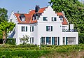
Wittlaer is Düsseldorf's richest district. The average annual income here is EUR 99,021 (as of December 31, 2007).
traffic
The light rail line U79 (formerly D-Bahn ) of Rheinbahn AG and Duisburger Verkehrsgesellschaft AG connects Wittlaer with Düsseldorf and Duisburg- Meiderich and thus connects Wittlaer to the Rhein-Ruhr light rail . The Dusseldorf airport can be reached in about 15 minutes by car and with the continuous bus 760. Within Wittlaers this bus is starting in Bockum as a feeder to the rail line U79.
| line | course | Tact |
|---|---|---|
| U 79 |
( U DU-Meiderich Bf 1 - High-floor operation of the Rheinbahn and DVG ; former D-Bahn ; Sections 4–5 belong to the Düsseldorf night network ; A special timetable applies during the school holidays. 10-minute intervals in the section 1-4 during the HVZ 15-minute intervals in the section 2-6 Sat 5-19 pm and in Section 4-5 Mon-Fri 21-0 pm (from 08.29.2018, before 8 p.m. to midnight), Sat 8 p.m. to midnight and Sun 5 a.m. to midnight, intervals of 30 minutes in section 2–6 Mon – Fri 7–10 p.m. and Sat 7–8 p.m. and in section 1–2 Sat 9 a.m. And Sun 12 pm–7pm |
15 min (1–3) 10/20 min (3–4) 10 min (4–6) |
| 760 |
D- Wittlaer-Bockum , Roßpfad - Wittlaer |
The B 8 extends to the east of the district . Relief was achieved in 2009 by the new expressway B8n ( A 59 ) running a few hundred meters further east , which currently already connects the A 44 , the airport and the city center with Wittlaer, and there is an expressway connection to the A 524 and over to the A 59 , A 52 and A 3 .
Attractions

- Roman Catholic Parish Church of St. Remigius ; Romanesque village church from the 13th century
- The St. Remigius parish also includes the Hubertus chapel, which was built in the 18th century . It is located around three kilometers northeast of Wittlaer in the Angermund district of Düsseldorf
- Hof Kaldenberg , a baroque, four-wing courtyard in the Einbrungen district
- former estate "Haus Melbeck"
- Rheinaue landscape protection area on the towpath
- The mouth of the Schwarzbach in the Rhine
- some other listed buildings

View into the main nave of the Catholic Church
House Melbeck

Schwarzbach in the Rheinaue

Evangelical foundation church contributions
House peacock


coat of arms
The historical community coat of arms, created by heraldist Wolfgang Pagenstecher in 1928/29 for the then new large community of Wittlaer and officially awarded on February 16, 1938, is split over a blue corrugated base and shows a gold-crowned and gold-armored red rooster ( Count von Spee ), behind in gold a black wall anchor (the princes of Hatzfeld ).
The base of the wave shield represents the Rhine bordering Wittlaer. The Spee'sche Hahn stands for the Heltorf Castle , which was part of the Spee'schen property and was located in the municipality at that time , and the Hatzfeld'sche wall anchor for the Kalkum Castle , owned by the Lords of Hatzfeld.
Life
Wittlaer is characterized by its excellent location and its distinctive village life. Numerous associations (such as TV Kalkum-Wittlaer , St. Sebastianus Brotherhood, volunteer fire brigade , church organizations) organize a community. Even if Wittlaer is a bit out of the way from the center of Düsseldorf, it can be reached in about 30 minutes thanks to good train and bus connections. But also in Wittlaer itself there are sights, some restaurants and pubs.
Shooting festival
An important part of social life in Düsseldorf-Wittlaer is the annual shooting festival on the district's Schützenplatz. The Schützen- und Heimatfest is organized by the St. Sebastianus Brotherhood, which was founded in 1431. The next edition of the festival will take place on June 22nd to June 24th.
Districts
Bockum

Geographical location: 51 ° 20 ′ N , 6 ° 44 ′ E
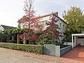
The part of Wittlaer north of the Grenzweg is the place "Bockum", which today has grown together with Wittlaer. Bockum is located directly on the Rhine at river kilometer 761. It celebrated its 700th anniversary on September 25, 2010. In the past, Bockum was a farming and fishing settlement. Bockum is a pure residential suburb with villa development and is one of the most expensive and exclusive residential areas in Düsseldorf due to its sought-after location on the Rhine and its rural character with a few farms. Former Federal President Richard von Weizsäcker lived here on the Rhine as early as the 1950s. In Bockum there is the waterworks II with historical buildings, which originally supplied the entire area of today's north of Düsseldorf with water. To the north are the remains of the old farming and fishing village of Rheinheim.
See Bockum (Düsseldorf) .
Contributions
Geographical location: 51 ° 19 ′ N , 6 ° 45 ′ E
On the south-eastern side of the district, the last major new building area Einbrungen von Düsseldorf was built from the late 1980s to 2006, despite violent protests from the long-established Wittlaerer . This area is a mix of single-family houses, condominiums, privately rented apartments and social housing. Simple houses and social housing in multi-storey buildings outraged the long-time residents. In addition, as many people moved as were already living in Wittlaer. Where a few years ago, in addition to a few residential buildings, a Protestant church and the Graf Recke Foundation, only agriculture was carried out, a large new building area has now emerged. In addition to the newly built station on the U79 underground line , a nursing home , two bakeries , a masseur , various doctors, two kindergartens and a supermarket have also settled in Einbrungen, so that there is a good infrastructure. For several years, the area northwest of the subway line has been built on. It is called a broom. Many single-family houses and apartments have been built there. There is also the popular North Cape youth recreational facility and a kindergarten.
Einbrungen has been settled since the 9th century. The name is derived from "Einbrunger", a family that settled here. The former paper mill at Schwarzbach in Einbrungen, which today serves as the home and studio of several artists , is of particular historical importance . The watermill was mentioned in a document as early as 1265, and its predecessor should have belonged to the royal court under King Arnulf around 900 . The original settlement was south of Einbrunger Straße from Hof Kaldenberg to Kalkum.
Frog pond

Froschenteich is located in the north of Wittlaer on the border with the Duisburg district of Huckingen . It is on the B 8 and has its own U79 stop, the so-called D-Bahn . This is where the entrance to the Dicken Busch forest area is located, which is also the park of Heltorf Castle . Froschenteich is characterized by the surrounding fields and equestrian sports. There are several small farms with farm sales and a restaurant. Residents fear that they will lose this local recreation area through the future establishment of another large new development area in the north of Düsseldorf, comparable to acquisitions.
education
There are several kindergartens in Wittlaer . The district also has a primary school , the urban Catholic Franz Vaahsen School. Secondary schools can be found in the neighboring district of Kaiserswerth .
See also
literature
- Magdalena Kraemer-Noble: St. Remigius in Düsseldorf-Wittlaer (Rheinische Kunststätten, issue 185), 3rd completely revised. Edition, Cologne 2000, ISBN 3-88094-864-X .
- Hans Stöcker (Ed.): Between Anger and Schwarzbach - History and stories from the former municipality of Wittlaer with the districts of Zeppenheim, Kalkum, Einbrungen, Wittlaer, Bockum and Froschenteich. 2nd edition, Düsseldorf 1976.
- Heinrich Lüssem: Wittlaer in view - poems. Düsseldorf 1996.
Web links
Individual evidence
- ^ Office for statistics and elections of the state capital Düsseldorf: Statistics for the district 054 - Wittlaer
- ^ Theodor Joseph Lacomblet, in: Document book for the history of the Lower Rhine or the Archbishopric of Cologne, Certificate 676. 1846, Volume 4, 1401 to 1609, p. [836] 810. Online edition 2009 [1]
- ^ Federal Statistical Office (ed.): Historical municipality directory for the Federal Republic of Germany. Name, border and key number changes in municipalities, counties and administrative districts from May 27, 1970 to December 31, 1982 . W. Kohlhammer, Stuttgart / Mainz 1983, ISBN 3-17-003263-1 , p. 291 .
- ↑ http://www.duesseldorf.de/statistik/stadtforschung/download/statistisches_jahrbuch_2012.pdf (link not available)
- ↑ Stöcker (1976), p. 185f and front cover. The title page shows a picture of the coat of arms, which can also be found here ( memento from June 10, 2007 in the Internet Archive ).
- ^ Brotherhood-Wittlaer. Retrieved June 20, 2017 .
- ^ Wittlaer: Village between large cities ( Memento from August 4, 2017 in the Internet Archive )
- ↑ Text excerpt from The Artists of the Einbrunger Mühle by Helga Meister, Beton Verlag, 1995
- ↑ KiTa.de, Berlin, Germany: Städt. Daycare center Wittlaerer Kirchweg . In: KiTa.de . ( kita.de [accessed June 20, 2017]).
| District 1 |
Old town | Carlstadt | Derendorf | Golzheim | Pempelfort | City center |
|
| District 2 | ||
| District 3 |
Bilk | Supplication | Friedrichstadt | Port | Hamm | Oberbilk | Unterbilk | Volmerswerth |
|
| District 4 |
Heerdt | Loerick | Niederkassel | Oberkassel |
|
| District 5 |
Angermund | Kaiserswerth | Calcum | Lohausen | Stockum | Wittlaer |
|
| District 6 | ||
| District 7 |
Gerresheim | Grafenberg | Hubbelrath | Knittkuhl | Ludenberg |
|
| District 8 |
Eller | Lierenfeld | Unterbach | Vennhausen |
|
| District 9 |
Benrath | Hassels | Heavenly Spirit | Holthausen | Itter | Rice wood | Urdenbach | Wersten |
|
| District 10 |