Pempelfort
|
Pempelfort district of the state capital Düsseldorf |
|||
|---|---|---|---|
|
|
|||
| Basic data | |||
| Geographic location : | 51 ° 14 ' N , 6 ° 47' E | ||
| Height: | 43 m above sea level | ||
| Surface: | 2.69 km² | ||
| Residents: | 31,897 (December 31, 2016) | ||
| Population density : | 11,858 inhabitants per km² | ||
| District: | District 1 | ||
| District number: | 014 | ||
| Transport links | |||
| Bundesstrasse : |
|
||
| S-Bahn : | S 1 S 6 S 11 | ||
| Light rail : | U 70 U 74 U 75 U 76 U 77 U 78 U 79 | ||
| Tram : | 701 704 705 706 707 | ||
| Express bus: | SB 50 SB 55 | ||
| Bus route: | 721 722 733 737 752 754 756 758 | ||
| Night traffic: | NE 1 807 | ||
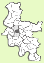
Pempelfort is a district of the state capital Düsseldorf . It is located in the middle of the city district 1 .
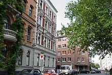
Because of its central location, its dense, mixed and historical development as well as its character by small businesses in the cultural and creative industries , it is considered a quarter with an urban atmosphere . Therefore, it is popular with young people and singles. The social structure in the district is multifaceted - both in terms of the age and income of its residents. There are many long-established residents who maintain the traditions of their respective communities, on the other hand there is a high fluctuation , for example from employees of large Düsseldorf companies who come from all over Germany and other countries and choose to live in the city of Pempelfort for the duration of their employment. Living in the streets north of the Hofgarten near the Rhine is particularly expensive . Towards the east, rental prices and the quality of the residential area decrease. The construction of the new Derendorf city quarters , planned with 139,000 m² of living space for approx. 3,000 residents and 311,000 m² of office space for approx. 9,000 workplaces, also called Le Quartier Central , is also intended to raise the level here and will probably contribute to further gentrification .
geography

The Düsseldorf district of Pempelfort borders the old town and city center in the south . To the west, the district is bounded by the Rhine , to the east by the main route of Deutsche Bahn AG and the district of Düsseltal . Parts of Pempelfort, even its most important supply center, Nordstraße , are often mistakenly counted as part of the Derendorf district, but this is actually only north of Jülicher Straße. The Kleverstraße separates PEMPELFORT to the north by the district Golzheim .
In a north-south direction, Pempelfort is cut through by Prinz-Georg-Straße, a busy main road with an arm of the Düssel flowing above ground in the tree-lined center . Another main road that Pempelfort crosses in a north-south direction is the Kaiserstraße , which runs further west .
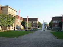
The district belongs to the central district 1 . Some important institutions are located here, such as the Düsseldorf District Government , the Düsseldorf Higher Regional Court , the North Rhine-Westphalia Ministry of Finance and the Ehrenhof museum complex with the Kunstpalast Museum , the NRW Forum and the Tonhalle . The Ergo Insurance Group / Victoria Insurance has its headquarters here.
The area around Nordstrasse, with its comparatively wide and deep range of retail, gastronomy and services, is the most important supply center north of the city center; it not only supplies Pempelfort, but also the Derendorf and Golzheim districts.
Demographics
With an area of 2.69 km², Pempelfort is the second largest and with around 32,000 inhabitants the largest and most densely populated part of the city district 1. It has a high population density with almost 12,000 inhabitants per square kilometer.
history


Until the beginning of the 19th century, the Pempelfort in front of the former city walls was only sparsely populated. Originally the dynasty seat of the Knights of Pempelfort is said to have been here at a ford across the Düssel . In the document for the town elevation of 1288, the estate of a "Rumpold in Pempelfort (Tempelfort)" is listed among others . Furthermore, the Rochus Chapel was consecrated in 1667 at the later location of the church of the same name. This was donated by the town council after the severe plague was over.
In 1854 the Prussian king named the area an official district next to the old town and Karlstadt as part of a city expansion plan. At that time, too, Pempelfort had only a few settlements and buildings, in particular the eponymous Gut Pempelfort , the former residence of the philosopher Friedrich Heinrich Jacobi , interspersed in a landscape that was mainly still used for agriculture and horticulture, under the buildings also built in the mid-18th century Jägerhof Castle .
On the basis of the city expansion plan, which was based on the Prussian alignment plan , Pempelfort quickly developed into a residential area for the upper middle class in the 19th century . Among the new residents were professors from the Düsseldorf Art Academy and established artists from the Düsseldorf School of Painting , who moved into their elegant townhouses in particular on Jägerhofstraße , as well as on Goltsteinstraße and Jacobistraße with the paint box and Jacobi's garden .
The courtyard garden , the oldest part of which was laid out between 1769 and 1771 , made a significant contribution to the popularity of the new district . After the demolition of the ancient fortifications of the courtyard was from 1804 in the style of an English park by Maximilian Friedrich Weyhe expanded considerably and has been gradually formed with monuments and dining options. For example, there was a garden bar at times in the Hofgärtnerhaus and a restaurant on the Ananasberg next to the pond at the Landskrone. In the western part of the Hofgarten there was the majolica house as a café , which was originally an exhibition pavilion for the 1902 industrial and commercial exhibition in Düsseldorf .
The Golzheimer Friedhof , the southern part of which is in the Pempelfort district, was laid out in 1804 and closed again in 1897/98. Today it is open as a park for walkers.
The artists' association Malkasten acquired the Jacobi house with the Jacobi'schen garden in 1861 and expanded it from 1864 to 1867 with the festival and society house. After the Second World War, the old Jacobihaus was rebuilt and connected to the new, modern society house.
The Catholic "Marien Hospital Association", founded in 1864, acquired part of the Stockkamper estate in 1866, west of the Düssel, in order to build the Marien Hospital there. The foundation stone was laid in 1867. The house received its first sick people in 1870. They were wounded in the Franco-German War . Heavily damaged in the Second World War, reconstruction was stopped in 1953 and the new Marien Hospital Düsseldorf was inaugurated in 1970.
In 1888, Prinz-Georg-Strasse was laid out as an avenue and named after Prince Georg of Prussia , a patron of the Historical Museum and the Düsseldorf rifle.
In 1897 the Rochus Church was consecrated and given to the community. The building of the Higher Regional Court dates from 1910, a year later the neighboring building of the district president was completed.
In 1902 the industrial and trade exhibition opened on the banks of the Rhine (at the location of today's Rheinpark ) and numerous buildings and halls formed the basis for a later exhibition center at this location. a. with the GeSoLei , the Great Exhibition for Health Care, Social Welfare and Physical Exercise in 1926. In 1971 the trade fair was relocated to its current location in Stockum and after 1990 the existing town hall gave way to the buildings of the administration of Victoria Insurance.
From 1907 to 1908, the architect Josef Kleesattel built the “artist's studio house” on Sittarder Strasse 5. This is where the Association of Düsseldorf Artists (VdDK), one of the oldest artist organizations in Germany, founded in 1844, is based.
In 1914, the section from Duisburger Strasse to Rochusstrasse was renamed Alt Pempelfort.
The Tonhalle moved into the former planetarium in the courtyard in 1978.
present
The Nordstrasse shopping street can be seen as the center of the western Pempelfort . It has shops for groceries, delicacies, organic and third world products, furniture, flowers, toys and stationery, clothing and sporting goods through book, wine and antique stores to opticians, goldsmiths, perfumery, toy stores, as well the only independent audio bookstore in Germany and much more. Thus it represents the largest shopping street in the city outside the city center. In between and in the side streets there are many pubs, restaurants and cafés; especially many Italians - from simple to noble.
The recently carefully renovated Art Nouveau Münster-Therme swimming pool is located on Münsterstrasse, near the triangle .
The center of the eastern Pempelfort is Derendorfer Straße with shops for daily needs. The area of the former freight station is also popular here , where some shops and restaurants offer their services. The Saturday indoor flea market had to give way to the start of the major construction project Neue Stadtquartier Derendorf at the end of 2007 , but the restaurant and club “Les Halles” continued to operate until the end of 2014. Until the entire site was taken over by the construction project, the restaurants in the former freight depot halls, whose junk interior gave the pubs their characteristic shabby chic , were also popular. The cafes, restaurants and bars further north in the Moltke and Tußmannstrasse area are still well frequented. At Kolpingplatz , which is framed by Klever Straße , Mauerstraße , Pfalzstraße and Schwerinstraße, the Rhenish farmers' market takes place on Wednesdays and Saturdays with a range of food and flowers from the region.
Attractions
- Theater Museum Düsseldorf
- Museum Kunstpalast ( Ehrenhof )
- NRW Forum (Court of Honor)
- Tonhalle (court of honor)
- Courtyard garden
- Malkastenpark (small historical private park of the artists' association Malkasten )
- Rheinpark (Pempelforter part south of an imaginary axial extension of Klever Straße)
- Historical cemetery Golzheim (Pempelforter part south of Klever Straße)
- Rheingärtchen (decorative garden on the banks of the Rhine )
- Jägerhof Castle
- Rochus Church
traffic
Pempelfort is served by a variety of trams (701, 704, 705, 706, 707) and bus routes (SB50, SB55, 721, 722, 737, 752, 754, 756, 758). In the west of the district, along Kaiserstraße, the U78 and U79 tram lines (here as an underground ) and the U70, U74, U75, U76 and U77 lines above ground on the Oberkasseler Bridge . In the East stations offer Wehrhahn and Zoo connection to the S-tracks S1, S6, and S11 of the S-Bahn Rhein-Ruhr and the Wehrhahnlinie (U71, U72, U73, U83).
For car traffic, the Kennedydamm feeder in the north of the district ensures quick connections to the motorways north of the city. The main connection to the south is the Rhine bank tunnel. In the course of the development of the former Derendorf freight station, the new Derendorf relief road as the main thoroughfare is to relieve the other north-south connections and ensure mobility for residents and employees in the “new district”.
literature
- Ernst von Schaumburg : Jacobi's garden in Pempelfort: a historical contribution to the celebration of the 25th anniversary of the artists' association 'Malkasten' ; along with a plan of the garden. Jacobi, Aachen 1873. Digitized edition of the University and State Library Düsseldorf
Web links
Individual evidence
- ^ Office for statistics and elections of the state capital Düsseldorf: Statistics for the district 014 - Pempelfort
- ↑ Le Quartier Central in Düsseldorf: ECE sells 25hours hotel project to Patrizia. Press release on the ECE Projektmanagement website , January 26, 2016. Accessed February 20, 2017.
- ↑ OpenStreetMap / Relation: Pempelfort (91061) . Retrieved August 7, 2009.
- ^ Wend von Kalnein (ed.): The Düsseldorf school of painting . Verlag Philipp von Zabern, Mainz 1979, ISBN 3-8053-0409-9 , p. 358, cat.-no. 122
- ^ JF Wilhelmi: Panorama of Düsseldorf and its surroundings. JHC Schreiner'sche Buchhandlung, Düsseldorf 1828, p. 139
- ^ Adalbert Natorp, in: Lecture: History of the Evangelical Congregation in Düsseldorf , Voss, 1881, p. [46] 42. Digitized edition of the ULB Düsseldorf
- ↑ Description of public sale: “The so-called Stockamper or Knappen Gut zu Pempelfort (...) consisting of a residential house, economic building, garden, Baumhof, Weyer and arable land, holding around 11 acres of 115 rods 30 feet Prussian. The Düsselbach flows through this property (…) ”. In Düsseldorfer Zeitung (No. 209) August 4, 1837 ( uni-duesseldorf.de )
- ↑ Entry in the monument list of the state capital Düsseldorf at the Institute for Monument Protection and Preservation
- ^ City of Düsseldorf: Master plan for the Derendorf freight yard
- ^ City of Düsseldorf: Development area of the Derendorf freight yard


