Friedrichstadt (Dusseldorf)
|
Friedrichstadt district of the state capital Düsseldorf |
|||
|---|---|---|---|
|
|
|||
| Basic data | |||
| Geographic location : | 51 ° 13 ' N , 6 ° 47' E | ||
| Height: | 38 m above sea level | ||
| Surface: | 1.0 km² | ||
| Residents: | 19,984 (December 31, 2016) | ||
| Population density : | 19,984 inhabitants per km² | ||
| Incorporation : | 1384 | ||
| District: | District 3 | ||
| District number: | 031 | ||
| Transport links | |||
| S-Bahn : | S 8 S 11 P 28 | ||
| Tram : | 701 704 705 707 | ||
| Express bus: | SB 50 | ||
| Bus route: | 721 722 732 736 780 782 785 835 836 | ||
| Night traffic: | NE 6 NE 7 NE 8 | ||
The Friedrichstadt district of Düsseldorf is located between the city center and the Bilk district of Düsseldorf in district 3 .
Around 20,000 people live there on an area of 1.0 km² (as of December 31, 2016). With a population density of 19,984 inhabitants / km², it is the most densely populated district of Düsseldorf and one of the most densely populated districts in Germany .
location
In the west, Friedrichstadt borders on Unterbilk , in the northwest on Carlstadt , in the north on the city center , in the east on Oberbilk and in the south on Bilk .
history
Friedrichstadt is a young part of old Düsseldorf. It was created in the middle of the 19th century as the city expanded south towards Bilk. A development plan for the future Friedrichstadt was drawn up as early as 1831, but development of the site did not begin until 1846. On July 3, 1854, the building permit was granted, shortly afterwards construction work began on the district, which was designed entirely on the drawing board with its chessboard-like basic pattern. The district was named in 1852 in honor of the Prussian King Friedrich Wilhelm IV. In the vernacular, the district was initially called " Wallachia ", probably due to its originally rather swampy ground.
The new Friedrichstadt soon developed into the preferred residential area, especially for civil servants and officers. With the opening of the train station in 1878, industry settled in the district and spurred its economic development, but the character of a residential town was retained. Much of the building fabric from the early days still exists today.
The green spaces with the ponds Schwanenspiegel and Kaiserteich were implemented by Maximilian Friedrich Weyhe . In 1880 the Prussian provincial parliament of the Rhineland moved into the Ständehaus , which until 1988 housed the state parliament of North Rhine-Westphalia . Today the building is called K21 and is a branch of the North Rhine-Westphalia art collection . Today the building and the surrounding green areas and ponds belong to the Unterbilk district .
During the Second World War , the Elisabeth-Charlotten-Schule (today Dumont-Lindemann-Schule) at Kirchfeldstrasse 74-80 was the satellite camp of Deutsche Erd- und Steinwerke GmbH (DESt) for the recovery of building materials. The SS had set up a place on Fürstenwall where the prisoners cleaned old bricks from rubble and then sold them again.
population
The district has a very high proportion of single residents and one-person households. Many residents are dependent on public funds. In addition, Friedrichstadt has an above-average proportion of foreigners at 28.2%; the average in Düsseldorf is 17.1%.
Description of the district
Given the high population density, there are very few green spaces worth mentioning in the district itself.
The historical Fürstenplatz is the only leisure and playground facility in the middle of the district. With its rounded layout in the north and south as well as some side streets running diagonally towards it, the square also deviates from the checkerboard pattern of the streets that otherwise dominates Friedrichstadt.
Economy and Transport
economy
Along with Nordstrasse and Rethelstrasse, Friedrichstrasse in the west of the district is one of the busiest shopping streets outside the city center. Until March 2016, this was where the 8,000 square meter Stern-Verlag Düsseldorf bookshop and the ASG education forum were located . To the east of Friedrichstrasse in the amount of belonging to Unterbilk church square are Portigon AG and the Rhineland Savings Banks Association based in several administrative buildings. Further to the north-west, Friedrichstadt borders the green spaces and ponds around the Museum for International Contemporary Art K21 in the Ständehaus .
Friedrichstadt is mainly home to jobs in the service sector , most of them in social security, legal, tax and economic advice and auditing, as well as in banking and private insurance. The main administration of the Deutsche Rentenversicherung Rheinland is located in the district; it is located in the second-highest skyscraper in Düsseldorf (122 meters), the former LVA main building .
The most important traffic artery of the district is the Corneliusstraße running in north-south direction, which connects the Autobahn A 46 with the adjoining Berliner Allee to the north and above it with the inner city. This results in an above-average traffic load for the residents, especially in the morning and late afternoon.
Until 1982, the production facility for the well-known Maoam sweets was on Hildebrandtstrasse in Friedrichstadt. Today the Creativcenter is located in the former factory building . The hackerspace of the Chaos Computer Club Düsseldorf Chaosdorf is located a little further on Hüttenstrasse .
traffic
The Friedrichstadt district is located in the city center. Numerous bus and tram lines are within walking distance; The Düsseldorf-Friedrichstadt S-Bahn station is also in the district .
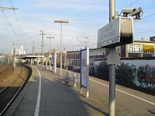
Friedrichstadt S-Bahn station: Düsseldorf-Friedrichstadt train station is about 1 kilometer south of Düsseldorf Central Station . It is located on the Mönchengladbach – Düsseldorf railway line and belongs to station category 4.
Location: The train station is centrally located between the districts of Düsseldorf-Friedrichstadt, Düsseldorf-Oberbilk and Düsseldorf-Bilk . It is located in an elevated position above Hüttenstrasse and Oberbilker Allee.
The S-Bahn station has a central platform with access to Hüttenstrasse and Oberbilker Allee.
Lines: The station is currently served by three S-Bahn lines; At the entrance to Hüttenstrasse, you can also change to tram line 705 ( Sonnenstrasse stop ), and at the southern entrance to bus line 736 ( Friedrichstadt S stop ). In addition to Düsseldorf Central Station, the airport and the major cities of Cologne and Mönchengladbach can be reached by S-Bahn .
| line | course | Tact |
|---|---|---|
| S 8 |
Hagen Hbf 1 - Status: May 2020 |
60 min (1–2) 20 min (2–3) |
| S 11 |
D-Airport Terminal - D-Unterrath - D-Derendorf - D-Zoo - D-Wehrhahn Status: timetable change December 2019 |
20 min |
| P 28 |
Kaarster See - Kaarster Bahnhof - Kaarst Mitte / Holzbüttgen - IKEA Kaarst - Neuss Hbf - Operation by the Regiobahn GmbH ; the section Mettmann Stadtwald - Wuppertal Hbf is expected to go into operation in 2020. |
20 min |
| 701 |
D - Rath , DOME / Am Hülserhof 1 - ISS Dome - Wahlerstr./ JVA - D-Rath 2 - D-Rath Mitte - Mörsenbroich , Heinrichstraße 3 - Derendorf - Derendorf , Rather Straße / HSD University - Pempelfort , Dreieck 4 - Venloer Str - Nordstraße - Pempelfort, Sternstraße - Stadtmitte , Schadowstraße - Steinstraße - Stadtmitte, Berliner Allee 5 - Friedrichstadt , Corneliusstraße - Morsestraße - Bilk , Karolingerplatz 6 - Kopernikusstraße → Am Steinberg ← Moorenstraße ← Merowingerplatz ← Bilk, Merowingerstraße 7 Mon-Sat daytime: section 1–3 every 20 min, section 3–7 every 10 min; Sun afternoons: Sections 1–3 every 30 minutes, Sections 3–7 every 15 minutes; in the evening every 20 minutes; further stops only in sections 2–4 and 5–6, but all transfer stops are listed. |
10 min |
| 704 |
Derendorf , Merziger Straße 1 - Rather Straße / HSD University - St. Vinzenz-Krankenhaus - Pempelfort , Stockkampstraße - Pempelforter Straße |
10 min |
| 705 |
D-Unterrath 1 - Unterrath , Eckenerstraße - Großmarkt - Johannstraße - Derendorf, Spichernplatz 2 - Pempelfort , Dreieck 3 - Venloer Straße - Nordstraße - Pempelfort, Sternstraße - Stadtmitte , Schadowstraße - Steinstraße - Stadtmitte, Berliner Allee 4 - D-Friedrichstadt , Helmholtzstraße - Sonnenstraße ( Friedrichstadt ) - Oberbilk , Kruppstraße - D-Oberbilk - Lierenfeld , Schlesische Straße - D-Eller Mitte - Eller, Vennhauser Allee 5 Operation at the standard cycle of the Düsseldorf trams; Sections 1–2 are only served every 20 minutes from Monday to Friday 6 am to 8 pm; further stops only in Sections 1–3 and 4–5, but all transfer stops are listed. |
10 min |
| 707 |
D-Unterrath 1 - Unterrath , Eckenerstraße - Großmarkt - Johannstraße - Derendorf, Spichernplatz - Pempelfort , Dreieck 2 ← Venloer Straße - Marienhospital - Pempelfort, Jägerhof Palace - city center , Jacobistraße 3 ( Pempelforter Straße , 200 m) - city center, Charlottenstraße / Oststraße - Central station - Friedrichstadt , Helmholtzstraße - Morsestraße - Bilker Allee / Friedrichstraße ( D-Bilk , 200–300 m) - Unterbilk , Bilker Church - Franziusstraße - Speditionstraße - Medienhafen, Kesselstraße 4 Operates at the standard frequency of the Düsseldorf trams, but every Saturday 9am to 8pm 10 min; further stops only in sections 1–2 and 3–4, but all transfer stops are listed. |
10 min |
| 732 |
Hafen , Lausward 1 - Bremer Straße 2 - D-Hamm |
|
| 736 |
Kirchplatz - Bilker Allee / Friedrichstrasse ( D-Bilk , 200–300 m) - Morsestrasse - Friedrichstadt - Oberbilker Markt - Lierenfeld , Langenberger Strasse - Ronsdorfer Strasse - Lierenfeld, Posener Strasse - Vennhausen , Gubener Strasse - In den Kötten 2 - Line branch 1: Vennhausen , Hürthstraße - Knuppertsbrück - Gerresheim - Gerresheim, Morper Straße / Linienast 2: Vennhausen , Freedom Estate - Am Ellerforst - Eller Hauptlinienweg: Mon – Fri 6 am–7pm every 20 minutes, Sat 7 am–7pm, Sun 9 am–7pm every day 60 min; Line branch 1: Mon – Fri 6 a.m. to 7 p.m. every 20/40 min; Line branch 2: every 60 minutes, times as for the main line route; further stops only in section 1–2 |
|
| 835 |
Niederkassel, Comeniusplatz - Oberkassel, Belsenplatz |
Public facilities
In the Friedrichstadt district, at Hüttenstrasse 68, the control center of the fire brigade of the Düsseldorf professional fire brigade is stationed. The Luisenstrasse Realschule, a building designed by Johannes Radke , is located at Luisenstrasse 73 .
Attractions
The Catholic Church of St. Antonius is the largest church in Düsseldorf and was built by the architect Wilhelm Sültenfuß in the late Romanesque style between 1905 and 1909. The St. Antonius Church has been a listed building since 1983 and was renovated in 1997.
The industrial fountain has stood on Fürstenplatz since 1939 . From 1913 to 1926 it was located in front of the former art exhibition palace . The three larger-than-life bronze sculptures were created by the sculptor Friedrich Coubillier and show the god Vulcanus , the miner and the ironworker .
Cabaret is performed in the Takelgarn theater atelier . Experimental theater is presented by the municipal forum for free theater .
See also
|
←
|
Lines |
→
|
||
|---|---|---|---|---|
| Central Station |
MG-D |
Bilk | ||
Web links
Individual evidence
- ^ Office for statistics and elections of the state capital Düsseldorf: Statistics for the district 031 - Friedrichstadt
- ^ Concentration camp satellite camp in Düsseldorf: Camp Kirchfeldstrasse, formerly the Deutsche Erd- und Steinwerke camp , accessed on September 15, 2017
- ↑ chaosdorf.de , website
- ↑ City of Düsseldorf: Fire Brigade - Overview of fire stations , queried on August 7, 2012
- ↑ Internet presence of the secondary school Luisenstrasse
- ↑ takelgarn.de , website


