
Wersten
|
district of the state capital Düsseldorf |
|||
|---|---|---|---|
|
|||
| Basic data | |||
| Geographic location : | 51 ° 11 ′ N , 6 ° 49 ′ E | ||
| Height: | 38 m above sea level | ||
| Surface: | 4.42 km² | ||
| Residents: | 27,232 (December 31, 2016) | ||
| Population density : | 6,161 inhabitants per km² | ||
| Incorporation : | April 1, 1908 | ||
| District: | District 9 | ||
| District number: | 091 | ||
| Transport links | |||
| Autobahn : |
|
||
| Bundesstrasse : |
|
||
| Light rail : | U 71 U 73 U 74 U 77 U 79 U 83 | ||
| Express bus: | SB 50 | ||
| Bus route: | 723 724 727 731 735 780 782 785 | ||
| Night traffic: | 817 | ||


Wersten is a district of Düsseldorf .
geography
location
The Wersten district is located in the south of Düsseldorf about halfway between the city center and Benrath and belongs to district 9 . In the west it borders on the campus of the Heinrich Heine University , which belongs to Bilk , and the Flehe district , in the north on the Oberbilk district , in the northeast on Eller , in the southeast on Holthausen , in the south on Itter and in the southwest on Himmelgeist . The closest point of the district boundary to the Rhine is about 460 meters from the bank of the Rhine. The largest extension of the district area is about three kilometers and extends along a line between east-northeast and west-southwest.
landscape
The meadows of the Rhine , which extended to the Gerresheimer Terrasse and to Unterbach and Hilden before the Rhine was regulated in the mid-19th century , also shaped the landscape of Wersten. Since the last Ice Age, the district area has been traversed by a sand ridge from the northwest to the southeast edge, i.e. in the course of today's Kölner Landstrasse . and towers above the surrounding area in Wersten by a few meters. The forecourt of today's Stephanuskirche on Wiesdorfer Straße , which was formerly called Am Sandberg , is also the highest point in Wersten. Rhine side, the terrain is stronger than the East and was of side arms crossed the Rhine. This is why this area was originally characterized by wet meadows and is still called Benden - a field name that is common in the Rhineland . For the same reason, the profile of the terrain is not completely flat, but troughs and ditches on the one hand and slight hills on the other can still be seen today.
The southern arm of the Düssel runs in the north of the district . At the so-called Werstener Kreuz (intersection Kölner Landstrasse / A 46 with the Düsseldorf-Wersten junction), the Brückerbach , another branch of the estuary , branches off in a south-westerly direction. Before 1908 it began further north at the point where the Francis de Sales Church is today. From there, the “Ikt-Bach”, known as the “Ikt Bach” until the beginning of the 19th century, flowed through Stoffeln and thus north-west around the present-day district. Until the construction of the Benrath Palace from 1756 to 1768, the Itter also flowed on the southwestern edge of today's district area , the course of which can still be partially traced using ditches, especially between the Am Haferkamp development and the Ickesward allotment gardening association .
Gravel mining was carried out in Wersten until the 1970s . While the quarry ponds in the east of the district have disappeared, two groundwater lakes on the northwestern edge near Stoffeln have been preserved: One lake is owned by the local fishing club, but is already in the Bilker area not far from the sports facilities of the Heinrich Heine University and therefore becomes a university lake called. The second lake to the north of it, on the other hand, is entirely in Wersten, was integrated into the Südpark for the 1987 Federal Horticultural Show and has been called Deichsee ever since .
population
On December 31, 2016 Wersten had 27,232 inhabitants. Two years earlier there were 14,263 private households, of which 7,126 were single households. At the same time, of the total of 3,846 residential buildings, 2,325 were single and two-family houses and the unemployment rate was 7.0 percent. Wersten is a traditional workers' residential area, which, however, underwent a significant upgrade, not least due to the construction of the Wersten motorway tunnel at the end of the 1980s.
Development

A block perimeter development, partly with Art Nouveau houses , prevails on the Kölner Landstrasse , which runs from northwest to southeast as the main street , the Burscheider Strasse, which runs parallel to the east, and the connecting cross streets. On the first floors of the Kölner Landstrasse there are predominantly and occasionally shops or similarly used rooms. Crafts and other service companies are also located in the courtyards .
In addition come settlement houses (single and semi-detached houses , built in 1930-60, as part of the densification also 1985-2005), terraced family houses (built in 1960 and younger) and multifamily or apartment buildings in an open design and different levels depending on the area shares in front.
Since the Middle Ages , a row village has developed to the left of the southern Düssel between today's street Am Dammsteg in the east and today's Franz von Sales Church in the north. Up until the second half of the 19th century, Wersten consisted almost entirely of farms. Only with the settlement of industrial companies in Oberbilk and Lierenfeld at the end of the 19th century and only a few decades later in Holthausen and Reisholz were more and more apartments required for workers and employees, which is why construction activity increased in Wersten as well. In the area of Werstener Dorfstrasse as the original main road and on the Kölner Landstrasse running west of it and then Provincial Road from Düsseldorf via Oberbilk and Benrath to Cologne , both apartment buildings and residential buildings with larger kitchen gardens were initially built without any planning in the urban planning sense . Examples of this type of building are
- the Ten Hüser from 1903 on Kölner Landstrasse before the intersection with Werstener Feld and
- the Lammers Hüser on Werstener Dorfstrasse.
In the 1920s, and especially after the First World War , the first settlements were now planned . In addition to smaller groups of houses such as the
- 1927 built war- damaged houses numbers 1 to 19 on Burscheider Strasse between Kampstrasse and Liebfrauenstrasse and
- Henkel houses numbers 204 to 214 built in 1930 at the eastern end of Werstener Dorfstrasse
larger quarters also emerged.
Despite this increased construction activity, many areas were barely or only little developed until 1960. The construction of the KAB settlement in the west of the Benden, the development of open areas between Burscheider Strasse and Kärntner Weg and the growth and densification of the Wersten Süd-Ost district , combined with the later demolition of the steel houses , heralded a second "building boom" one who deals with
- the expansion of the Green Settlement to the west and east around 1970,
- the construction of the Wersten West district in the first half of the 1980s,
- the sewer system and the redesign of the streets and the start of redensification in the Benden,
- the establishment of the Düsseldörfchen on the occasion of the Federal Garden Show 1987 ,
- the development of the area between Werstener Kreuz, Kölner Landstrasse, Rheindorfer Weg and the Brückerbach,
- the 1992 completed business center in connection with the extension of the Guerickeweg to the Kölner Landstraße and
- the development of the last arable land in the district between Mendelweg and Wersten West in the second half of the 1990s
continued. Two of the above-mentioned construction measures also created space for new shops and restaurants , which also resulted in a discounter market of another retail chain coming to Wersten and two supermarket and discounter chains that had already been established for many years were able to maintain their location in a central location by moving to larger rooms .
Among other things, the construction of the Guerickeweg residential park on Kölner Landstrasse and the development of open spaces
- southeast of Ickeswarder Straße between Dechen- and Scheideweg (Ernst-Abbe-Weg) ,
- at the eastern end of Werstener Dorfstrasse (Tiroler Weg) until 2003,
- north of the street Am Gansbruch ( Brassertweg and Nöggerathweg ) until 2005 and
- behind the church of St. Maria in den Benden (Flemingweg) until 2006
with single-family houses set further urban development accents in Wersten after the turn of the millennium.
Green settlement
As early as November 1917, the non-profit association for country house settlements acquired properties north of the Düssel that were still part of the Eller district . On December 31, 1919, the groundbreaking ceremony for the construction of a larger settlement took place here. By 1927, 357 houses with 573 apartments had been built in an area that extends to today's Harffstrasse . In 1927 the Düsselheim restaurant was opened , the hall of which was still one of the largest event rooms when it closed on June 30, 2001 and thus played a central role in Wersten club life. The Green Settlement was separated from the Catholic parish of St. Gertrud in 1932 and incorporated into the parish of St. Maria Rosenkranz and since then has also been politically part of Wersten. Around 1970, further areas were built on west of the original settlement on Wipperfürther and Lenneper Strasse , east of it to the Eller cemetery - Bruchhausenstrasse - and on Harffstrasse with single and multi-family houses. In the meantime, a conservation statute has come into force for the area that includes the original settlement and, further south, Werstener Dorfstrasse.
Settlements on Halbuschstrasse
At the Halbuschstraße originated from 1922, the mirror glass settlement and in 1935 the Sibiu settlement
Wersten south-east
To the south-east of the Werstener Feld street , one of two Düsseldorf steel house settlements with 246 apartments for refugees and deportees, some of whom have large families , was built by 1929 . Even after the steel houses were demolished between 1967 and 1972 and the subsequent redevelopment, including several high-rise buildings, this quarter has remained a social hotspot .
In the ends
In 1923 the first house was built in this area. About where the parking lot of the sports field is today, there was already a brickworks with a ring oven . In addition, this area was used exclusively for agriculture. In 1934 the area-wide development of the Benden with settlement houses began and the first streets named after natural scientists were built . At the crossroads , the new sports field of SV Wersten 04 was laid out in 1949. Nine years later, the construction of the Catholic Church of St. Maria in den Benden began in the immediate vicinity of the former brickworks , which was inaugurated in September 1959 after only one and a half years of construction.
At the end of the 1950s, the south-western part of the Benden was still undeveloped except along the street Auf'm Rott . On a slight hill between the Brückerbach and Auf'm Rott , the KAB Düsseldorf housing association built a settlement with terraced single-family houses and social housing in multi-family houses around 1961 , which is why it is still called the KAB settlement today. This settlement was of course also connected to the sewer system. Many long -established residents of the Benden had to wait until the 1980s for this convenience . Up to this point in time, the streets were paved but not paved and had no sidewalks . In the 1980s, densification began in the Benden , which was largely completed in the first decade of the 2000s.
Today, two green areas run through the Benden , on the one hand a green space leading around the KAB settlement and the adjacent buildings along a former loop of the Brückerbach (see map from 1872) with a paddock and a large playground with several adventure areas and on the other hand a green area along one former arm of the Rhine not far from the Kölner Landstrasse, also with many play options.
Intersection Auf'm Rott with Dechenweg and Ohmweg

Dechenweg seen from the crossing Auf'm Rott / Ohmweg
Geisslerweg looking to the west

Dopplerweg in southern viewing direction

Senefelderweg in the KAB settlement


Wersten-West
The quarter to the north-east of Münchener Strasse , consisting of one to four-storey single and multi-family houses, has a varied design and is developed in an almost ring-shaped manner from Otto-Hahn-Strasse, which runs between Auf'm Rott and Ickeswarder Strasse . Exposed brickwork made of bricks and pitched roofs made of roof tiles characterize the outer shape of most houses. As before in the Benden, well-known natural scientists were the inspiration for the naming of the streets.
Until the second half of the 1970s, agriculture was practiced south of the Mendelweg as far as Itter and Himmelgeist . Then, starting from Ickeswarder Straße, construction work began on the new district. In 1980, the first residents moved into the apartments on Fritz-Strassmann-Straße , a spur road that branches off from Otto-Hahn-Straße to the south . From there, the quarter grew further north in a few years and several construction phases.

The central area bounded by Otto-Hahn-Straße is accessed by two short dead-end streets of the same name and Lise-Meitner-Straße as a longer cul-de-sac. Otherwise there are only footpaths where the entrances of many houses are located. In the eastern part there is a long L-shaped pond, on which mostly row single-family houses with wooden gables are located. Subsequently, two-story, one-story and four-story apartment buildings are arranged in such a way that several inner courtyards are created with sufficient space for the residents' gardens on the ground floors but also for communal play areas. These courtyards can be reached through passages in the buildings. Along a short pedestrian zone there are several smaller shops and a popular Greek restaurant, but no supermarket . There are now two day-care centers not far from here , but the next elementary school is one to one and a half kilometers away outside the district.
To the west of the central area runs Max-Born-Strasse , on which there are apartments for students from the nearby Heinrich Heine University , financed according to the client model . Around a decade later, a larger facility operated by the Studierendenwerk Düsseldorf was built near the northern end of the quarter . Other areas remained undeveloped for up to 15 years. A gap in the central area was only closed in 2001, which is why the prevailing architectural style there differs from the surrounding area. The individually designed single-family houses that were created in the course of the redensification along the crossroads and Ickeswarder Strasse, which was completed earlier, are also accessed from Otto-Hahn-Strasse and the Pascalstrasse that branches off there .
Düsseldörfchen
To tradition Federal horticultural shows with urban projects to connect the following was Düsseldörfchen as "model-Area" of the Bundesgartenschau 1987 planned. The multi-family and row single-family houses of the first construction phase were built from November 9, 1985 (laying of the foundation stone) on the bank of a former quarry pond - the center of the landscape park Vor dem Deich in the south of the exhibition grounds and today's Südpark - and completed by the opening of the garden show. The construction is similar to that in Wersten West, whereby streets also lead through the passages in buildings and thus almost every single-family house can be reached directly by car and has a carport . After the Federal Horticultural Show, the Düsseldorf village was to be expanded on the site that reached as far as the Kölner Landstrasse, which was recently characterized by the rather disorderly settlement of small businesses. First a large lawn was created there. However, this second construction phase was no longer implemented. Instead, Provinzial Rheinland built its new administration building there, which it moved into on January 19, 1995.
history
Until about 1850
Excavation finds from the district area - a bell beaker and a hand ax , exhibited in the city museum - suggest that this part of the Rheinaue was already settled in prehistoric times.
Relatively few reliable documents are available from the historical development of Wersten in the Middle Ages, since no knight's seat can be proven. There are no chronological records of the few larger and old farms that also exist in Wersten. In old map sketches all farms are to the left of the southern Düssel and to the north south of the Brückerbach . They are arranged in the northwest at the level of the former Scheidlingsmühle on today's Kölner Landstrasse, first south to the beginning of today's Werstener Dorfstrasse and then running east to Dammsteg and Oerschbach . Later, with increasing development, the Werstener Dorfstraße was built for the eastern part .
1050 or 1063, the time differs depending on the source, Wersten is first mentioned in writing as “Werstine” in the Frithericus foundation deed . In a further deed of foundation, Gatefridus de Erprothe , it is mentioned in 1150 as "Werstyne" . In 1218 it was referred to as "Warstein" in a lift register from Gerresheim . In 1360 Wersten was assigned to the ducal Bergische Amt Monheim . In a list of the Monheim office from 1363 on the associated regional courts, heavenly spirits are listed among other things. The Himmelgeist district court must also have been responsible for Wersten at this time, as a jury member from Wersten was named in a certificate from 1368. The text section reads: “Before Wilh. de Wersteyn and Henr. dictum appear at the Aldenbrücken et ceteris scabinis (lay judges) in Homelgeist… ” . In 1498 a land sale Auf'm Rott in Wersten and in 1525 the course of the border river Brückerbach, " de op dat Roytt (= Rott ) heard ", were negotiated before the lay judges of the "Landgericht zu Hymelgeist" .
A Scheidlingsmühle is mentioned in a document from 1439. Scheidling is probably a modification of the name of a tenant for this mill. The name is given in 1273 with Ropertus de Schadelich . In 1893 the mill, which was now only used as a warehouse, burned down. At first a restaurant was operated in its place and the Franz-von-Sales-Kirche was built from 1969 to 1971 .
Wersten was sacked as early as 1588 during the armed conflict between Philip II of Spain and the Union of Utrecht . Like many other places in Germany, it was frequently plundered during the Thirty Years' War . It was caused by Spanish soldiers in 1622, imperial soldiers in 1633 and Swedish soldiers in 1634 . From 1639 to 1642 imperial troops set up quarters in the south of Düsseldorf, which also affected Wersten.
Reliable older data are available in documents for the larger farms for Barfeshof , Oerschhof and Gut Hohensand . The Barfeshof, also called Berfes- or Berwitthof, was at the level of Dorfstrasse 62-66 directly on the Düssel. It was probably created between 1000 and 1100. Since Barfes was a keep in Low German and means witt white, the “white tower” is likely to give this courtyard and also the name Wersten (defense tower = Wehrstein = Wersten). Since at that time courtyards with a fortified tower were only built by tenants , this courtyard probably originally belonged to a member of the nobility . This is also supported by the fact that later, next to the barfeshof, an “An der Leut Hof” (also called Hof zur Leuchten ) can be proven. This points to a subsequent division of the original manor and servants' yard into two separate yards. According to the entry in the Himmelgeister church book, a Henrich Rohr, who was also the church master of Himmelgeist, was a half man at the Berfess farm from 1661–65 . For the construction of the southern Düsseldorf motorway feeder to today's BAB 46 as well as the landscape and local planning in 1927, the farm had to give up a lot of land and was demolished in 1928.
The Oerschhof was a large and old farm . It was in the area of the Eselsbach. His lands partially extended into the Reisholz area. The court is mentioned in an old document written in Latin. A translation of a part of the text reads: "In the area of Werstyne, in the Elp, the Oerschhof was bequeathed as a foundation to the altar of 'Saint Mary in Paradise' under Archbishop Anno in 1062" . In 1218 the farm was owned by the Gerresheim monastery. The tenant at the time had to pay tithing to the monastery . In the lease letter from Abbess Jutta von Daun of April 12, 1420, the farm is called "uff de Uersel, vulge Ursch" . Further dates for the farm are for 1577, a pledge, and 1829, Baroness von Bönningen is the owner, as well as 1914 and 1920. Due to land tax, for example for the Düsseldorf – Cologne railway line, the cultivated area became smaller and smaller from the middle of the 19th century. It was therefore abandoned and demolished in the first half of the 20th century.
Another large farm was the Hohensand estate. It was on the Kölner Landstrasse, formerly known as Provinzialstrasse, north of the Scheidlings watermill. The following dates are known about this estate: Around 1700 a Johannes Wülfing owned the estate. According to the land register, Professor Pampus was the owner in 1788. In 1829 the estate was sold by the widow Korf to Heinrich Keusen from Hamm. With the construction of the railway station on Harffstraße (1st half of the 20th century) and the tram depot on Siegburger Straße (built until 1914) the farm lost more and more land and was given up.
Other farms, of which at least one old date is available in documents, are listed below. The annual dates of the deeds are given in brackets: Heukes- also called Heusenhof (1780 owner Fam. Custodis), Lindenhof (1654 owner Fam. Engels), Helpertz-Hof (paid a tithe to St. Nikolaus in the 17th and 18th centuries Himmelgeist), Potthof (1691 owner Mrs. Achens and Lampenscherf), Schultheishof (owner 1780 Fam. Krüll) and Nixenguth (1791 owner Michael Nix).
Wersten Himmelgeist was affiliated with it from the beginning of the records. During the Napoleonic reorganization of the German western states in 1806, Himmelgeist-Wersten became one of the four rural communities that belonged to Mairie Benrath in the canton of Richrath in the Grand-Ducal Bergisch canton . Even later, after the county of Berg was taken over by the King of Prussia in 1815, the community of Himmelgeist-Wersten remained part of the mayor's office of Benrath. In a list from 1817 after the end of the French era, an associated village of Windfoch was also listed under the village of Wersten. The name Windfoch was probably due to a large windbreak lane that a very strong storm at the end of the 18th century had caused in this area. The north-eastern area to the left of the Düssel was called Wersten and the north-western area below the Brückerbach was called Windfoch . This division for the municipality part Wersten into the areas Windfoch and Wersten was also given unchanged in 1836 in a further list of the municipalities in the district of Düsseldorf.
From around 1850
Until the middle of the 19th century, Wersten was a purely farming community. The number of residents in the area of Wersten with Windfoch was 392 in 1817. With the increasing industrialization of the south of Düsseldorf, this structure changed. Many workers and simple employees from the industry from the neighboring communities settled here and houses with rental apartments were increasingly being built. Furthermore, the area of many farms was reduced by converting the fields into building land or in many cases by changing the use of gravel or clay pits. As a result, they were either part of a sideline or were given up entirely. The management of the last, meanwhile, smaller farms was ended in the middle of the 20th century and the rural past is thus extinguished.
The number of residents in the Wersten municipal area rose to 5550 by 1908 and, in addition to the even more populated area of Benrath, belonged to the area in the joint mayor's office of Benrath, which had an unusually high influx of residents. Because of this high population growth and the necessary structural development in the late 19th and early 20th centuries, Wersten had problems securing the municipal supply of its community area. The financial tasks of the municipalities included securing the police, building the necessary schools with the salaries of teaching staff, maintaining and building new roads and paths, supporting the poor and supplying them with electricity, gas and drinking water, including the Sewage discharge. The latter became increasingly a problem for Wersten. There was no sewage system for the discharge of the sewage and the sewage and the sludge from the septic tanks were disposed of by the farmers with field fertilization. However, as more and more arable land in Wersten was used for brickworks and gravel extraction, bottlenecks were to be expected due to the shrinking areas. The growing need for water for the growing population, which was no longer secured by the existing Benrath water supply, was also precarious.
To solve these problems, the Werstener sought, without a heavenly spirit, a connection to the city of Düsseldorf. As early as February 11, 1903, 5 Werstener members of the municipal council made 2 demands in a letter to the Mayor of Benrath, Steinhauer. The first demand concerned the future provision of gas and water by Düsseldorf. The second demand was the incorporation of Wersten without Himmelgeist into Düsseldorf. These demands were not supported by the mayor of Benrath and the district administrator of the Düsseldorf district was strictly against the removal of Wersten from the district. Nevertheless, the contracts of 1906 and the amendments from 1907 resulted in a contractual delivery of gas and water through Düsseldorf to Wersten.
With these supply contracts, the first steps towards incorporation of Wersten into Düsseldorf were initiated. In a vote by the community council of Himmelgeist-Wersten on November 14, 1906, 16 out of 20 members opposed the separation of the entire community from the district, but all 20 were in favor of Wersten being incorporated into Düsseldorf. Already one year before the territorial reform of 1909 (Düsseldorf details here ) the district president informed the district administrator of the Düsseldorf district that according to the Prussian king's decree of November 16, 1907, Wersten would be separated from the community of Himmelgeist-Wersten and incorporated into Düsseldorf. This incorporation came into force on April 1, 1908.
In contrast to the northern and southern neighboring communities, no major industrial companies have settled in Wersten. The only exceptions were a few small businesses such as a bread factory and a larger laundry with cleaning and two large service companies. From 1913, the tram built a depot on Siegburger Strasse, which was completed by 1916 and put into operation on July 1, 1916. In 1928 the railway set up a storage station and in 1932 a large roundhouse on Harffstrasse. However, until 1932 the area of the Green Settlement , and with it Harffstrasse with the parking station, still belonged to Eller. Until then, the municipality of Wersten was only south of the Düssel. In the 1970s, the maintenance of steam locomotives was ended and then switched to the maintenance of S-Bahn.
Since loam and gravel soils were widespread in Wersten, many of these areas were exploited for the lively construction activities in the Düsseldorf area. Gravel pits and brickworks were built from the end of the 19th century. Some of the wastelands that emerged after these pits were exploited were recultivated and / or built on again for a short time, but many only after decades. For example, the area between Burscheider Strasse and Kölner Landstrasse south of Kampstrasse was rebuilt for a short time. Other areas with such wastelands were: in the north-west large areas of the "Bende", originally called Windfoche , the area south-west of the former Scheidlingsmühle, with two large quarry ponds and today's south park, the middle north-east from the Kölner Landstrasse, today partly to the green settlement and belonging to the extension area of the Eller cemetery, as well as in the northeast south of Werstener Dorfstrasse and Oerschbachstrasse. These areas are now largely built on with houses or are used as allotment gardens. In some cases, this new use and development did not take place until the middle of the 20th century. Today the original excavation of the clay can still be seen in places because the gardens behind the houses are well below street level.
In the sidewalk on Werstener Dorfstrasse in front of house number 84, there is a stumbling block that reminds of Baltasar Sieberg who lived here and was executed on April 7, 1945 .
Municipal boundary
Historical boundaries of districts are not comparable with today's municipal boundaries . They encompassed a general area, such as forest, swamp and wasteland, the so-called common marrow , and the parceled marrow with the arable land belonging to the individual goods / farms. The latter was the "divided field mark" . Sometimes also pure wasteland and forest areas without a larger settlement, so only a largely "common mark" , were referred to as a district. An example of this in the greater Düsseldorf-Süd area is the "Reisholz district" forest area , which has been used for centuries as a location in documents.
Precisely documented municipal boundaries only emerged with the formation of municipalities and the more modern municipal administration order in the Grand Duchy of Berg under the French and their then extensive takeover by the Prussians . The parcel cadastre legally ordered for taxation by the French from 1808 onwards were recorded and documented in the so-called original cadastre plans. The plans and information about the localities created during this period did not always correspond to the older historical districts . Deviations from this were not uncommon. Examples of the documentation of the 'new' municipal boundaries in the south of Düsseldorf are the 'Handriss der Landbürgermeisterei Benrath' from 1821 and the statistics for the administrative district of Düsseldorf, which were published in 1836 by JG von Vierbahn. However, the northwestern part of Wersten was referred to as Windfoch in both documents . It is not known exactly from when the name Windfoch was used. In a map of the Duchy of Berg drawn up by S. Sanson in 1696, the area east of Stoffeln is so named.
All older documents for Wersten show that from the Middle Ages onwards, when the area of today's Werstener Dorfstrasse was settled, it was largely aligned with the spirit of heaven . The reason for this was that it belonged to the regional court and parish there for centuries. Until 1889 Wersten did not have its own Catholic parish and was affiliated to St. Nikolaus in Himmelgeist. As far as old documents and information on Wersten are available, these refer to a district of Himmelgeist-Wersten . This also applies to the original cadastre that was created for the “rural community of Himmelgeist-Wersten” at the beginning of the 19th century. This cadastre shows the following demarcations to the neighboring districts and localities at that time:
- in the northwest of Stoffeln , a hamlet in the district of Bilk . The southern part of Christophstraße with the Stoffler Broich belonged to Wersten. The remaining border to the north above Scheidlingsmühle belonged to the Eller district . As already mentioned, Wersten was originally only to the left of Düssel and Brückerbach. This 'northern limit' also applied to the Oerschbach in the northeast. The current Brückerbach branches off significantly more south from the Düssel than the historic one. The splitting system for Düssel and Brückerbach was only created in the 20th century in 1908 and is located in the area of the current Wersten Cross . The northern border of Wersten is currently at Harffstrasse.
However, the affiliation of individual farms to the districts was sometimes disputed or changed. For example, the large Oerschhof , which was to the right of the Oerschbach in the Elpe corridor , was at times included in both Wersten and Eller. The northwest border to Bilk was similarly fluid. For example, there is evidence that the Scheidlingsmühle belonged to the Düsseldorf-Bilk district. In the land tax book of 1632 this mill was listed under fabrics (Stoffeln).
- In the east Wersten was bounded by Eller, whose southern border was then still in the area of today's district of Hassels . Reisholz as part of the municipality was only created in 1901. The entire Hallbusch area in the southeast still belonged to Wersten. Only part of Hallbusch was ceded to Reisholz in 1901.
- In the south Wersten was bordered by the villages of Holthausen and Itter , which were joined by Himmelgeist in the western area .
According to the older districts, as well as the original cadastre, the area from Düssel / Abzweig Brückerbach east of today's Siegburger Straße originally belonged to Eller and west to Stoffeln. These limits, based on Eller / Wersten / Stoffeln, were also indicated unchanged in the original cadastre from 1830 to 1848 for Eller and in a map from 1879 for the mayor of Benrath.
Even before Wersten was incorporated into Düsseldorf in 1908, on July 15, 1901, part of the Halbusch corridor from Oerschbachstrasse was assigned to the newly formed Reisholz community. Further changes after the incorporation were:
- In 1909 the rest of the Halbusch corridor with 56.5 hectares was spun off to Groß-Benrath , and there to the town of Holthausen. There was no longer a border with rice wood.
- Also in 1909 the borders between Stoffeln and Wersten were changed.
- Since 1932, the area to the right of Düssel and Brückerbach with Siegburger Straße and Grüne Siedlung no longer belongs to Stoffeln and Eller, but to Wersten.
- With the expansion of the federal highway B 326, later expanded to the BAB 46 , the road connection between Am Dammsteg and Werstener Dorfstraße that had existed for centuries was abolished in 1963–1964 and an overpass structure for pedestrians over the BAB 46 was built. Since then there has been no normal connection and the Dammsteg can only be reached directly from Wersten via this pedestrian bridge. In 1972 the area on the "Dammsteg" was spun off to Eller.
- Also in 1972 both the Stoffler Broich with the southern part of the Christophstraße and the northern area of Wersten above the intersection of Kölner Landstraße / Harffstraße were spun off to Bilk.
Culture and sights
Parks and green spaces
South park

For the Federal Horticultural Show in 1987 , the Volksgarten in Oberbilk , which had existed since the end of the 19th century, was expanded to the south to an area of 70 hectares. This is how the Südpark was created , which is the largest park in Düsseldorf. 23 hectares of its area are in the southern part in Wersten and called Vor dem Deich . The landscaped park around a former quarry pond is also a popular meeting place for families with children, as there is a petting zoo , a mini golf course and a café . The workshop for adapted work (WfaA) - a Düsseldorf workshop for the disabled - not only operates these facilities, but also maintains the parts of the south park outside the Volksgarten and sells organically grown products there. There are six allotment gardens at and in the Südpark , of which the Neuland eV allotment gardening association is located in Wersten area.
graveyards
Deceased residents of the district find their final resting place today in the cemeteries in Eller , Itter and Stoffeln . But with the exception of the southern extension of the Stoffeler cemetery, which was built in 1975, all areas are outside the district. In the past there was a Catholic cemetery on today's Werstener Friedhofstrasse (formerly Viehstrasse ) not far from Hügelstrasse since September 25, 1898, and a Protestant cemetery since 1905.
regional customs
Customs are maintained in Wersten mainly by the local rifle club (founded in 1925) and the local heritage club (Werstener Jonges eV, founded in 1953). The shooting festival always takes place on the second weekend in June.
sports clubs
The oldest and best-known sports club in the district is "SV Wersten 04 eV", which was founded in 1904 as the Germania Wersten 04 gymnastics club . In 1912 this club was expanded to include a football department. The first soccer field was on the site on which the “White School” was later built. As early as 1920, the soccer field was relocated to a site on Werstener Friedhofstraße that had originally been used by a brickworks to mine clay. The last relocation of the soccer field to Bende took place in 1949. The sports facility is located between Dechenweg (corner of Flemingweg) and Scheideweg. It includes an artificial turf pitch, two hard rubber pitches and an ash pitch. The club has both a football and a handball department.
Other well-known sports clubs in Wersten are:
- the "DJK Rheinland 05 eV" founded in 1905 with departments for football, gymnastics and table tennis. Badminton, basketball and volleyball are also played.
- the "TTC Champions eV", created in 2002 through merger: This association emerged from the TTC Schwarz-Gold Wersten founded in 1970 with the TTG Reisholz / Hassels.
Other clubs are
- the 1977 founded "Tennis Club TC 77" and
- the "Chess Club Wersten 1964"
Churches and Religious Life

In Wersten there are two Catholic parishes , which since 2008 along with the communities of St. Nicholas , St. Joseph and St. Hubertus in Himmelgeist , Holthausen and Itter the Seelsorgeeinheit Düsseldorf Rheinbogen form, and a Protestant church , belongs to the well Himmelgeist. There are also churches and centers of a Russian Orthodox community, the Raven brothers and a Sufi order in Wersten .
Wersten originally belonged to the Catholic parish of St. Nikolaus. In 1893 three quarters of the 2,400 parishioners lived in Wersten. The chapel congregation , which had existed since the blessing of an emergency church on August 13, 1893, was elevated to a parish on March 22, 1901. In 1953 the Archdiocese of Cologne decided to divide the parish of St. Maria Rosenkranz into four parishes. With the inauguration of the Church of St. Maria in den Benden in September 1959, the second parish was established, which in 1984 became part of the pastoral care unit that "only" consisted of two Wersten parishes . In the summer of 2016 the foundation stone was laid for a building complex from Burscheider Straße 22 to Rodenbirkener Straße 19. Since the beginning of 2018, the pastoral office of the pastoral care unit and the parish and family center St. Maria Rosenkranz have been located in this new building and the associated listed former chaplaincy with the parish hall and the Montessori children's house. Three of the seven other day-care centers run by the pastoral care unit are also in Wersten.
Until the end of the 19th century, only a few Protestants who belonged to the Urdenbach parish lived in Wersten . In 1832 19 of the 485 inhabitants were Protestant. With the beginning of industrialization, many Protestants also moved to Wersten, which is why the Eller -Wersten community was founded on October 1, 1904 , and a community and prayer hall was built on today's Wiesdorfer Strasse in 1911. The Evangelical Church Community of Düsseldorf-Wersten with three parishes and 4,640 members was created on July 6, 1947 through the division of the Eller-Wersten community. The prayer room, which was only used as a parish hall from 1958 after the inauguration of the Stephanus Church, was later demolished to make room for the new parish center. At Pentecost 1992 the Stephanushaus and the modernized daycare center at Wiesdorfer Strasse 13 and 15 were opened. From 1965 there was a second place in Wersten, the Lydiahaus opposite Schützenplatz, where Protestant services were regularly celebrated. In the meantime, the Ulrike-Frey-Haus is a Diakonie Düsseldorf facility for young mothers and fathers. The second day care center of the community at Leichlinger Strasse 68 has remained on the property . The youth center is located in the rear building of the former Catholic elementary school (Werstener Dorfstrasse 90a) in the back yard .
Practiced ecumenism plays an important role in Wersten. The joint social activities of the Catholic and Protestant communities in Wersten resulted in 2004 With Heart and Hand for Wersten - Don Bosco Foundation . The purpose of this foundation is according to "in particular the procurement of funds to promote child and youth work, as well as the promotion of charitable purposes with the aim of fighting poverty and unemployment in the district". She “tries to network and improve the social offers, as well as to promote cohesion in the district”. The contact point and venue is the Wersten district shop on Liebfrauenstrasse 30, which the foundation maintains together with the Caritas Association Düsseldorf . In addition, the congregations celebrate joint services, including the Holy Mass on the occasion of the shooting festival and ecumenical activities on Whit Monday .
The Iranian- born Sufi order Maktab Tarighat Oveyssi Shahmaghsoudi ( MTO Shahmaghsoudi for short ) has a center in a former print shop on Harffstraße 29. The around 150 students at the Sufi school, which has been based in Düsseldorf since 2000, meet once a week to religious sessions in which the Koran is recited, talked about Islam from the perspective of Sufism, prayed together and the Dhikr commemorates God . Since 2011, MTO Shahmaghsoudi has also owned a cultural association that offers Persian language and cooking courses as well as courses on Tamarkos - a type of Sufi meditation - and has been running a day-care center in Eller since November 2017. The joint celebration of the annual Nouruz festival with interested Wersten people, the participation in festivals of the Catholic and Protestant communities in Wersten and the cooperation in refugee aid are examples of how MTO Shahmaghsoudi is involved in the district and participates in interreligious dialogue .
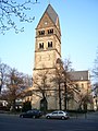
Church of St. Mary Rosary
A Catholic church building association was founded as early as 1884 , which in June 1890 acquired a piece of land at the current location of the church. The neo-Romanesque basilica designed by the architect Wilhelm Sültenfuß was consecrated on October 23, 1910 after around three years of construction. It was badly damaged in the last two years of World War II , so it took until 1955 to rebuild. A war memorial from 1934 is located opposite the church portal.
Stephanuskirche
The foundation stone for a Protestant church on Wiesdorfer Strasse was laid on July 21, 1957. The modern hall church was inaugurated at Pentecost on May 25, 1958 . The Stephanuskirche is located at the highest point of Wersten, which was formerly called Sandberg . Its location on the extended axis of Liebfrauenstrasse, at the end of which is the Catholic Church of St. Maria Rosenkranz, is intended to express the commitment to ecumenism in urban planning. The church is set back from the street, creating a forecourt. This is bounded on both sides by a single-storey wing that houses toilets, group rooms and a kitchen, among other things. Inside the church, the large cross on the altar wall impresses, the shape of which is modeled on the famous statue of Christ in Rio de Janeiro . The organ, which has more than 2500 pipes, is remarkable. The crypt under the chancel is also unusual for a modern Protestant church building . There is a photovoltaic system on the roof .
Church of St. Maria in den Benden
By the architect Emil Steffann and Nicholas Rosiny explicitly into the landscape and buildings of Benden fitted Catholic Church in the form of a protective stable, which also includes other community facilities, was opened in September 1959 after eighteen years of construction. An extension with an enlarged parish hall and additional group rooms has been in use since 1985. The Catholic Polish Mission in Düsseldorf is also located in the parish center, which is why a Holy Mass is celebrated here every Sunday and public holiday in Polish.
Church of St. Nicholas of Myra
The Russian Orthodox Church on Werstener Feld 65, consecrated to St. Nicholas of Myra , was built around 1960 by the Diakonisches Werk as an Orthodox center for the exiled and diaspora communities and for decades it was built jointly by the communities of the Ukrainian , Romanian , Serbian and Russian Orthodox Church used. Since the beginning of 2008 it has been used only by the Orthodox Parish of the Holy Archangels , which belongs to the exarchate of Orthodox communities of Russian tradition in Western Europe and which previously celebrated its services in the Jan Wellem Chapel in Hamm . In the church there are works by the artist Hildegard Bienen .
Brethren's Meeting Room
The church building on the street Auf'm Rott (corner of Robert-Meyer-Weg ) was originally used by a congregation of the New Apostolic Church . After this congregation was dissolved, it was sold to the Plymouth Brethren Christian Church - also known as the Raven Brothers .
St. Maria Rosenkranz, Burscheider Strasse 22

Stephanuskirche, Wiesdorfer Straße

St. Maria in den Benden, Dechenweg 40

Church of St. Nicholas, Werstener Feld 65

Brethren's Meeting Room, Auf'm Rott


Economy and Infrastructure
Road traffic

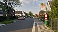
Even during Roman times , a road led from Duisburg to Cologne over the ice age sand ridge in Wersten. Before it was incorporated into Düsseldorf on October 9, 1908, it had changing names with Provinzialstraße , Cölner Chaussee and Kölner Chaussee , and since the incorporation it has been called Kölner Landstraße . Already in the Prussian period as a provincial road in the trunk road network, the Kölner Landstrasse was part of the federal highway 8 until the 1970s . Most of the most important shops are located on it, so that it forms the elongated district center between Werstener Dorfstrasse and Ickerswarder Strasse. It was not until 1923 that Werstener Straße was laid on a dam between Kölner Landstraße and Stoffler Kapellchen . As a result, Bilk and the old town were now directly accessible without a detour via Oberbilk. This new connection was widened as early as 1936 for the construction of the “southern motorway feeder”.
With the increasing car traffic after the last world war, the traffic situation on the Kölner Landstrasse became more and more problematic. This mainly affected the intersection area with the “southern feeder” (former B 326, now A 46), which was created for today's A3 in 1936 and 1937 and connected Düsseldorf to the south with the motorway and parallel to the Werstener to the north Dorfstrasse ran. This intersection, called "Werstener Kreuz" , became a storage area that mainly cut the district in a north-south direction. With the construction of a temporary high bridge, which was in operation from 1969 to 1984, the traffic on the B 326 was led over the intersection and an attempt was made to defuse this congestion area. But with the increasing volume of traffic, the congestion grew stronger.
With the expansion of the federal highway to the A 46, the high bridge was replaced by a tunnel from 1984 to 1986 and the congestion problem was finally solved. This means that the northern settlement areas are no longer cut off from the center of the district. The multi-lane Münchener Straße built in the 1970s on the western edge of the district takes up a large part of the through traffic from the city center to the south and in this way also relieves the Kölner Landstraße.
Local public transport
There are three tram stops within the district , of which the Werstener Dorfstraße stop is an important junction that is served by all tram lines, one express bus line and five city bus lines in daytime traffic:
| line | Line route |
|---|---|
| U 71 |
D-Rath 1 - Heinrichstraße 2 - Brehmplatz - D-Wehrhahn 3 - Pempelforter Straße - Schadowstraße - Heinrich-Heine-Allee - Benrather Straße - Graf-Adolf-Platz - Kirchplatz - D-Bilk 4 - Uni-Kliniken - Südpark 5 - Werstener Dorfstraße - Opladener Straße - Ickerwarder Straße - Elbruchstraße - Holthausen 6 - Benrath Castle - D-Benrath 7 - Benrath depot Further stops in sections 1–3, 4–5 and 6–7 |
| U 74 |
Meerbusch - Osterath , Görgesheide 1 - Lörick 2 - Belsenplatz - Tonhalle / Ehrenhof 3 - Heinrich-Heine-Allee - Steinstraße / Königsallee - Oststraße - Düsseldorf Hbf Further stops in section 1–3 |
| U 77 |
Am Seestern 1 - Belsenplatz - Tonhalle / Ehrenhof 2 - Heinrich-Heine-Allee - Steinstraße / Königsallee - Oststraße - Düsseldorf Hbf Further stops in section 1–2 |
| U 79 |
Duisburg-Meiderich Bf 1 - Duisburg Hbf Further stops in section 1–3; stops at 4 on both the U74 / U77 platform and the U71 / U83 platform |
| U 83 | Gerresheim, Hospital 1 - Schlüterstraße / Employment Agency - D-Wehrhahn 2 - Pempelforter Straße - Schadowstraße - Heinrich-Heine-Allee - Benrather Straße - Graf-Adolf-Platz - Kirchplatz - D-Bilk 3 - Uni-Kliniken - Südpark 4 - Werstener Dorfstraße - Opladener Straße - Ickerwarder Straße - Elbruchstraße - Holthausen 5 - Schloss Benrath - D-Benrath 6 - Depot Benrath Further stops in sections 1–2, 3–4 and 5–6 |
| SB 50 |
D- Pempelfort , Rheinterrasse - Tonhalle / Ehrenhof 1 - peak hours every 20 minutes, Mon – Sat every 30 minutes, Sun every 60 minutes, in the evening every 60 minutes and additional trips between 1 and 2; Section 3–4 via the A 46 ; further stops only between 4 and 5 |
| 723 |
Hafen , Plange Mühle 1 - Medienhafen, Kesselstraße - Franziusstraße - Unterbilk , Bilker Church - D-Völklinger Straße |
| 727 |
Bilk , Südpark |
| 780 |
D- Altstadt , Heinrich-Heine-Allee |
| 782 |
D- Altstadt , Heinrich-Heine-Allee |
| 785 |
D- Altstadt , Heinrich-Heine-Allee |
| 817 |
Heinrich-Heine-Allee - Düsseldorf Hbf - Oberbilk - Wersten - Holthausen - Benrath night traffic from Sun / Mon to Thu / Fri; from Heinrich-Heine-Allee 0:53, 1:53 and from the Benrath depot 0:07, 1:07 and 2:57 |
This means that there are not only direct connections to almost all neighboring districts and the city center, including the main train station, but also to the neighboring cities of Duisburg , Krefeld , Meerbusch , Haan , Erkrath , Hilden and Langenfeld .
In the direction of Holthausen / Benrath follow the tram stops Opladener Straße and Ickeswarder Straße , which are no longer served by the U 79. The former is so central that many shops, public facilities such as the citizens' office and city library and the churches can be reached via short footpaths. The latter offers transfer options to bus lines 731 and 735, which have direct connections to Benden and Wersten-West and also to Heinrich Heine University and the new development areas in Himmelgeist and to Eller, in particular to the Eller cemetery and the S-Bahn Establish stopping points Eller Süd and Eller .
With Südpark , Provinzialplatz and Elbruchstraße there are three more tram stops on the suburb of Bilk, Oberbilk and Holthausen. The former is another important public transport hub, which is not only served by the four light rail lines U 71, U 73, U 79 and U 83 and the NE 7 night express, but also the terminus of both bus lines SB 57, 731, 735 and 827 to the university and on to Hellerhof , Am Pflanzkamp in Eller, Erkrath- Unterfeldhaus and Neuss - Norf as well as line 727 to Reisholz S-Bahn station via IKEA and, at times, line 723 to S-Bahn station Eller Mitte .
history
On December 12, 1898, the first trams ran on today's Kölner Landstrasse . The initially single - track meter - gauge line from Oberbilk to Benrath belonged to the Benrath tram network , which was operated by Bergische Kleinbahn AG . From September 26, 1911, the Rheinbahn leased and operated the Benrath network after the city of Düsseldorf had acquired it from the Kleinbahngesellschaft shortly before. Around the Benrath and Dusseldorf tram network to be able to run continuously been in Oberbilk with the 1914 Umspurung the track to standard gauge begun. At the same time a second track was laid. On June 1, 1917, this construction work ended in Benrath. Presumably immediately afterwards there was a direct connection from Benrath via Wersten and Oberbilk to the city center, but it can only be said with certainty that line 18 on the route from Benrath station - Holthausen - Wersten - Oberbilker Markt - main station - Bismarckstrasse - Corneliusplatz - Mühlenstrasse - town hall from 1926 - Flinger Strasse - Hindenburgwall was running.
On October 14, 1934, the tram route along Werstener Strasse, built in 1923, between Stoffler Kapellchen and Kölner Landstrasse was put into operation. Line 1, which previously ran on the Rath - Nordstrasse - Königsallee - Graf-Adolf-Platz - Bilk train station - Städtische Krankenanstalten - Stoffeln , was extended to Holthausen. Evidently since 1938 it has been running, like line 18 at that time, via Holthausen to Benrath. For a quarter of a century there were no further changes to the tram lines in Wersten. Only the relocation of the tram tracks from Königsallee to Berliner Allee in 1955 also had an impact on the route of Line 1 outside the district area. Furthermore, the dismantling of the tracks in the old town in the early 1960s led to the extension of line 18 over the Oberkasseler bridge to the Rheinbahnhaus in Oberkassel .
On July 29, 1973, however, more extensive changes in the tram network came into force, which also directly affected Wersten: The new line 15, which runs on the Holthausen - Wersten - Uni-Kliniken - Bilk Bahnhof - Wilhelm-Marx-Haus - Oberkassel, Rheinbahnhaus route during the day Operated Mondays to Saturdays and for a while also in the afternoon on Sundays and public holidays, restored the direct connection to Bilker Bahnhof and to western Friedrichstadt , which had been discontinued in the 1950s due to changes to Line 1. In order to cope with the strong increase in business and school traffic between the main train station and Holthausen, the trips on line 11 between Kaiserswerth and the main train station have been extended accordingly during rush hour . Lines 1 and 18 were retained, apart from the fact that line 18 ran from Jan-Wellem-Platz instead of Oberkassel to the Rheinstadion and the new exhibition grounds .
On October 3, 1981, the first subway tunnel section between Kennedydamm and the Opera House went into operation, which also had a greater impact on Wersten: Lines 711 and 718 were shortened so that they no longer ran through the district. The new line 717 took over the function of line 718 to Jan-Wellem-Platz, from where it continued to the Rheinbahnhaus in Oberkassel. Line 715 was even dropped completely. Instead, the routes on line 703 between Gerresheimer Bahnhof and Kirchplatz were temporarily extended to Holthausen. With the opening of the inner city tunnel between Heinrich-Heine-Allee and the main train station in 1988 and the Oberbilker U-Bahn tunnel on June 15, 2002, there were no line changes in Wersten, but travel times to the inner city were both significantly reduced. Today you can reach the Hauptbahnhof underground stations in eight and Heinrich-Heine-Allee in twelve minutes from the Werstener Dorfstraße stop .
Since August 30, 2010, the U 79 tram has been running through Wersten due to its extension to the East University / Botanical Garden . This was preceded by a change south of the district, which primarily affected "mobility-restricted" Wersten residents: With the extension of the U 74 to Benrath from September 25, 2009, every second journey that had been used since 2000 and now exclusively on line 701 was terminated Low-floor trams of the type NF10 , which guarantee barrier-free entry and exit, are connected during the day in Holthausen and thus halve the direct connections to Benrath during this busy time.
On February 21, 2016 - a little more than 117 years after the first tram passed through Wersten - the tram era ended: since the opening of the Wehrhahn Line , only light rail vehicles have been running in Wersten, at least in regular service and from a technical point of view, which is also part of that you can see that "U" is in front of the line numbers. As early as February 27, 1994, line 717 became lines U 74 to Lörick and U 77 to Seestern , which have since been operating at the same rate as the old line.
The first city bus route through Wersten went into operation on May 3, 1964. Line 37 initially ran between the terminus Am Dammsteg in Eller and Dopplerweg at the end of Ohmweg in Benden via Werstener Feld , Ickeswarder Straße , Scheideweg and Auf'm Rott and was extended to Getrudisplatz on October 7, 1966 . The final stop in Wersten and the Nernstweg , Mendelweg and Scheideweg stops in the direction of Eller were canceled again in 1969 and journeys from Eller were made from the Ohmweg stop via Dechenweg back to Eller. In the mid-1980s, after completion of the Wersten-West settlement southwest of the Benden, the bus line , which now ended in Eller at the Vennhauser Allee stop and was renumbered to 737 in 1980, ran through the new district via Otto-Hahn-Straße instead of the Scheideweg . Since the 1990s, instead of line 737, line 735 has been running between Unterbach, later Erkrath - Unterfeldhaus and the Südpark . The loop travel in one direction of travel became again traffic through the Benden and Wersten-West in both directions, which was continued via Münchener Straße and Universitätsstraße and so Wersten better with Heinrich-Heine-Universität and the stop on, which has been expanded to become a public transport hub Südpark connected. Also because of the strong increase in the number of passengers between Wersten and Eller, line 731 between Am Pflanzkamp in Eller and Südpark was opened on April 28, 2014 , which mostly has the same route as line 735, but runs along Ickeswarder Strasse in its full length from Monday to Friday and at other times the loop through the Benden and Wersten-West was put into operation instead of the 735 line, which was then shortened to the Erkrath - Eller section.
Trade and commerce
Wersten is characterized by a wide variety of retail stores that are located south of the motorway access along the Kölner Landstrasse. Daily and periodic needs can be met here, and longer-term needs are also partially covered. In terms of culinary delights, in addition to traditional cuisine through pubs, Greek and Asian snacks, and to a lesser extent Italian pizzerias and Turkish doner kebab shops, are characteristic.
Since 1995, the largest company based in Wersten has been Provinzial insurance.
Public facilities
The Wersten police station is manned around the clock, is located at Kölner Landstrasse 30 and can also be reached on 0211 8709343. Fire station 7 of the Düsseldorf fire brigade is located on Werstener Feld 30 .
Child care and schools

The first Catholic elementary school was set up by the French in 1810 on Kölner Landstrasse 42 in what was then the village area of Windfoch. This school closed in 1868. A new Catholic elementary school was built on Werstener Dorfstrasse 90 and opened in 1869. In 1901 the “Red School” was built at the intersection of Werstener Feld and Werstener Friedhofstraße. Called the Red School because red and not plastered bricks were used for the outer walls of the building. On January 3, 1906, the first elementary school for Protestant children went into operation on Wiesdorfer Strasse. Until the construction of a third building for Protestant pupils in 1909, the school on Werstener Dorfstrasse remained a purely Catholic school, since until around 1900 there were only a few Protestants in Wersten. After the First World War in 1936, the “White School” was built on the corner of Burscheider Strasse and Lützenkircher Strasse. After 1945 various other schools were built as the population continued to grow. In 1981, after more than 112 years, the cath. School at Werstener Dorfstrasse 90 ended and the building continued to be used as a community center the following year.
Currently there are elementary, community, comprehensive and secondary schools as well as vocational colleges in Wersten, while grammar schools are located in neighboring districts.
Wersten has 820 places in 15 different day-care centers run by municipal and church sponsors and around 1000 primary school students in municipal and church primary schools as well as 135 special needs students.
Web links
- Office for Statistics and Elections of the State Capital Düsseldorf, Statistics for the City District 09 ( Memento from October 23, 2008 in the Internet Archive )
- State capital Düsseldorf - Brief description of Wersten ( Memento from July 2, 2008 in the Internet Archive )
- Evangelical parish Düsseldorf-Wersten
- Informative district portal for Düsseldorf-Wersten
Individual evidence
- ^ Office for statistics and elections of the state capital Düsseldorf: Statistics for the district 091 - Wersten
- ↑ a b Dr. Karl Dross: Wersten street names and their history in Wellbeing in Wersten - the informative internet portal for Düsseldorf-Wersten of the SPD local association Düsseldorf-Wersten
- ↑ Official website of the city of Düsseldorf, In: Office for Statistics and Elections State Capital Düsseldorf.
- ↑ a b c d e f g h i j k l m n o p q r s t u v w x y z aa ab ac ad ae af ag Heimatverein Werstener Jonges eV: Wersten> History> Anno 1063 to this day in wellbeing in Wersten - the informative internet portal for Düsseldorf-Wersten of the SPD local association Düsseldorf-Wersten
- ↑ Residential parks / developer measures by Ferox Projektentwicklung GmbH & Co. KG
- ^ Pastoral care unit in Düsseldorf Rheinbogen : St. Maria in den Benden, Wersten
- ^ Heimatverein Werstener Jonges eV: Wersten> Geschichtliches> Historie in Wohlfühlen in Wersten - the informative internet portal for Düsseldorf-Wersten of the SPD local association Düsseldorf-Wersten
- ↑ In: Issue 9 ; Benrath historical, series of publications of the archive of the home community Groß-Benrath; P. 58.
- ↑ In: Certified original cadastral drawing from July 4, 1906 for the district of Himmelgeist-Wersten .
- ↑ City Archives State Capital Düsseldorf, in: Timeline up to 1300 .
- ↑ In: Volume 15 ; Benrath historical, series of publications of the archive of the home community Groß-Benrath; P. 16.
- ↑ deed dated 15 July 1498 (with Pressel of Schöffentumssiegels to "Hemel spirit" ); Historical archive of the city of Cologne (holdings 1 main document archive, U 1/16354).
- ^ Document of October 25, 1525; Historical archive of the city of Cologne (holdings 1 main document archive, U 1/16354).
- ↑ In: Issue 9 ; Benrath historical, series of publications of the archive of the home community Groß-Benrath; P. 60.
- ↑ In: Issue 9 ; Benrath historical, series of publications of the archive of the home community Groß-Benrath; Pp. 60-61.
- ↑ a b In: Issue 9 ; Benrath historical, series of publications of the archive of the home community Groß-Benrath; P. 61.
- ↑ In: Issue 9 ; Benrath historical, series of publications of the archive of the home community Groß-Benrath; Pp. 61-62.
- ↑ In: Issue 9 ; Benrath historical, series of publications of the archive of the home community Groß-Benrath; Pp. 62-63.
- ↑ In: Issue 9 ; Benrath historical, series of publications of the archive of the home community Groß-Benrath; Pp. 64-68.
- ↑ steel. In: Description of the administrative district of Düsseldorf . 1817, p. 101
- ^ Johann Georg von Viebahn (ed.): Statistics and topography of the government district of Düsseldorf. Düsseldorf 1836, second part, p. 70.
- ↑ In: Issue 3 ; Benrath historical, series of publications of the archive of the home community Groß-Benrath; P. 7.
- ↑ In: Issue 9 ; Benrath historical, series of publications of the archive of the home community Groß-Benrath; Pp. 63, 64.
- ↑ In: Issue 3 ; Benrath historical, series of publications of the archive of the home community Groß-Benrath; P. 7.
- ↑ In: Issue 3 ; Benrath historical, series of publications of the archive of the home community Groß-Benrath; P. 6.
- ^ Hugo Weidenhaupt: Düsseldorf, history from the origins to the 20th century , 1988, Verlag Schwann / Patmos, Volume 3, p. 174, ISBN 3-491-34223-6 .
- ↑ In: Issue 3 ; Benrath historical, series of publications of the archive of the home community Groß-Benrath; P. 14.
- ↑ In: Issue 3 ; Benrath historical, series of publications of the archive of the home community Groß-Benrath; P. 12.
- ^ Hugo Weidenhaupt: Düsseldorf, history from the origins to the 20th century , 1988, Schwann / Patmos publishing house, volume 3, p. 175, ISBN 3-491-34223-6 .
- ^ City history: City of Düsseldorf
- ^ Weidenhaupt, H .: A short history of the city of Düsseldorf. Triltsch Verlag, Düsseldorf 1979.
- ↑ In: Issue 3 ; Benrath historical, series of publications of the archive of the home community Groß-Benrath; P. 27.
- ^ In: Stadtarchiv Düsseldorf , Geschichtenkartei, Volume QS, p. 194.
- ↑ Düsseldorfer Stadtchronik, under: Events after year from 1909 , year 1916.
- ^ Administrative report of the state capital Düsseldorf, in: Remarkable incidents , 1914/19, p. [19] XVII. Online version
- ↑ a b NRZ, in: Article series: Mein Wersten , July 20, 2013.
- ↑ In: Volume 15 ; Benrath historical, series of publications of the archive of the home community Groß-Benrath; Map p. 26 + 27.
- ↑ In: Issue 9 ; Benrath historical, series of publications of the archive of the home community Groß-Benrath; P. 63.
- ^ In: Certified redrawing from July 4, 1906 ; Original cadastre Himmelgeist-Wersten.
- ^ Editor H. Ferber; In: The land tax book of Düsseldorf from 1632 ; Reprint, 1881, p. 49.
- ↑ In: Issue 11 ; Benrath historical, series of publications of the archive of the home community Groß-Benrath; P. 61.
- ↑ In: Issue 3 ; Benrath historical, series of publications of the archive of the home community Groß-Benrath; P. 51.
- ↑ In: Volume 3 ; Benrath historical, series of publications of the archive of the home community Groß-Benrath; P. 66.
- ↑ In: Volume 15 ; Benrath historical, series of publications of the archive of the home community Groß-Benrath; Map p. 26 + 27.
- ^ Budget of the state capital Düsseldorf, in: Extraordinary Budget Plan , 1965, p. [258] 261. Online version
- ↑ a b Pastoral care unit in Düsseldorf Rheinbogen : St. Maria Rosenkranz, Wersten. Retrieved May 3, 2016 .
- ^ A b Pastoral care unit in Düsseldorf Rheinbogen : St. Maria in den Benden, Wersten. Retrieved May 3, 2016 .
- ^ Johann Georg von Viebahn (ed.): Statistics and topography of the government district of Düsseldorf. Second part, section Düsseldorf, p. 70
- ^ Evangelical parish in Düsseldorf-Wersten
- ↑ With heart and hand for Wersten - Don Bosco Foundation / Who we are
- ^ MTO in Düsseldorf
- ↑ RP-Online, Beate Gostincar-Walther, March 19, 2016: Sufi community celebrates its spring festival
- ^ MTO Persian School
- ↑ MTO day care center
- ↑ Manfred Becker-Huberti (ed.): Düsseldorfer Kirchen - Die Catholic Kirchen im Stadtdekanat Düsseldorf , JP Bachem Verlag, Cologne 2009, p. 91f.
- ↑ Rolf Purpar: Art City Dusseldorf , Grupello Verlag Dusseldorf 2009, p 358th
- ↑ Manfred Becker-Huberti (Ed.): Düsseldorfer Kirchen - Die Catholic Kirchen im Stadtdekanat Düsseldorf , JP Bachem Verlag, Cologne 2009, p. 87.
- ↑ NRZ, in: Article series: "Mein Wersten" , July 16, 2013.
- ↑ NRZ, in: Article series “Mein Wersten” , July 24, 2013.
- ^ Richard Jacobi, Dieter Zeh: The history of the Düsseldorf tram - From the horse tram to the city railway . EK-Verlag, Freiburg 1995, ISBN 3-88255-401-0 .
- ^ University of Düsseldorf: Extension of the U 79 officially approved
- ↑ RP-Online: Extension of the U79 to the university is open
- ↑ RP-Online: U74 extension - new railway to the south
- ↑ Antenne Düsseldorf: New Rheinbahn timetable - more buses in the south
- ↑ https://duesseldorf.polizei.nrw/wachenfinder
- ^ State capital Düsseldorf (ed.): 125 years of professional fire brigade Düsseldorf , Düsseldorf 1997, p. 157f.
- ↑ In: Issue 3 ; Benrath historical, series of publications of the archive of the home community Groß-Benrath; P. 42.
- ^ City of Düsseldorf, Office for Statistics and Elections
Remarks
- ^ As the crow flies Johanneskirche - Church of St. Maria Rosenkranz : 4.85 km; Beeline Church St. Maria Rosenkranz - Schloss Benrath : 4.58 km; Measurements carried out on April 1, 2018 using Google Maps.
- ↑ Distance from the bridge on Münchener Strasse over the Brückerbach to the banks of the Rhine measured on April 1, 2018 using Google Maps.
- ↑ As the crow flies between the bridges of the A 46 over the street Am Dammsteg and the Münchener Straße over the Brückerbach, measured on April 1, 2018 using Google Maps.
- ↑ The Lammers houses got their name from the farm of the same name on Werstener Dorfstrasse 122 and were to the west of the farm.
- ↑ In an advertisement for the leasing of the newly built mill in the "Gülich and Bergische Nachrichten", No. 1, 1769, the name "Schallings-Mühle" is used.
- ↑ According to another assumption, a medieval defense tower in the area of an intersection “Old Heerstraße on the right bank of the Rhine with a Landwehrwall” could have given the name.
- ↑ Belonging to Wersten in: Archive Groß-Benrath, Issue 9, p. 61; Belonging to Eller in: JG von Vierbahn, 1836, part two, listing localities, p. 71.
- ^ Eller original cadastre and map from 1879, drawn by A. Hofacker, are in the Groß-Benrath archive.
- ↑ In the agreements between the city of Düsseldorf and the district of Düsseldorf for the incorporation of 1909, it was agreed on Jan. 7, 1909 that this small area should be "ausgemeindet" from Wersten again. (Düsseldorf, in: Report on the status and administration of community affairs for the period April 1, 1909 - March 31, 1910 / The incorporated communities of 1909. ) S. [43] XLV. Online version
| District 1 |
Old town | Carlstadt | Derendorf | Golzheim | Pempelfort | City center |
|
| District 2 | ||
| District 3 |
Bilk | Supplication | Friedrichstadt | Port | Hamm | Oberbilk | Unterbilk | Volmerswerth |
|
| District 4 |
Heerdt | Loerick | Niederkassel | Oberkassel |
|
| District 5 |
Angermund | Kaiserswerth | Calcum | Lohausen | Stockum | Wittlaer |
|
| District 6 | ||
| District 7 |
Gerresheim | Grafenberg | Hubbelrath | Knittkuhl | Ludenberg |
|
| District 8 |
Eller | Lierenfeld | Unterbach | Vennhausen |
|
| District 9 |
Benrath | Hassels | Heavenly Spirit | Holthausen | Itter | Rice wood | Urdenbach | Wersten |
|
| District 10 |