
Graefrath
|
Graefrath district
City of Solingen
|
|
|---|---|
 |
|
| Area : | 12.46 km² |
| Residents : | 18,725 (Dec. 31, 2015) |
| Population density : | 1,503 inhabitants / km² |
| Incorporation : | August 1, 1929 |
| Postal code : | 42653 |
| Area code : | 0212 |
 Location of the Graefrath district in Solingen
|
|
 The market square in Graefrath
|
|

Gräfrath is the smallest of the five Solingen districts . Due to the Augustinian monastery founded in the 12th century, which existed until the 19th century, Gräfrath was one of the most important cities in the Bergisches Land for a long time . In the 19th century, the world-famous ophthalmologist Friedrich Hermann de Leuw practiced here .
District Mayor Gräfraths is Udo Vogtländer ( SPD ), his deputy is Petra Steinheuer ( CDU ).
With its well-preserved old town, largely dating from the 18th and 19th centuries, around the market square at the foot of the monastery church, Gräfrath is one of the 56 historical city centers in North Rhine-Westphalia.
geography
Gräfrath, in the north of the city of Solingen, borders on the neighboring cities of Haan in the west and Wuppertal in the north and east. The Solingen district of Mitte joins in the south, while Gräfrath forms an inner-city border with the Wald district in the west . The city limits to Wuppertal form in large parts of the river Wupper . The city boundary to Haan is partly formed by the Itter , which rises in the Holy Born in Gräfrath and flows into the Rhine near Düsseldorf - Benrath . Numerous other streams run through Gräfrath, such as the Nümmener or the Holzer Bach.
In Gräfrath, near the former water tower and today's light tower , Solingen's highest point is located at a height of 276 meters above the NHN .
Living spaces

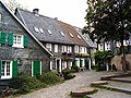
In addition to the historic town center, today's urban district of Gräfrath also includes various other residential areas and locations, some in the form of hamlet-like courts , some of which are located off the main thoroughfares of today. Over the decades, larger residential districts have developed from some court estates, in which the original courtyard buildings have almost disappeared. There are the following locations in Gräfrath:
Altenfeld | Apple tree | Aue | Belt mill | Backesheide | Bergerbrühl | Bimerich | Flower valley | Bush | Buscher field | Buxhaus | Honor | Own field | Egg passport | Flockertsberg | Flockert wood | Focher Dahl | Peace Valley | Fürkeltrath | Grünewald | Reason | Goodness | Heather | Heider Hof | Hostel | Ketzberg | Külf | Laiken | Mühlenbusch | New Egg Pass | Neuenhaus | New bull | Nümmen | Obenflachsberg | Obenscheidt | Up to the wood | Paashaus | Piepersberg | Rauenhaus | Rathland | Ringhouse | Sheep House | Schieten | Turnpike | Schönhof | Steinbeck | Stöckerberg | I. Stockdum | II. Stockdum | III. Stockdum | Tummelhaus | Unterflachsberg | Down to the wood | Vogelsang | Central | Brick field
Since the beginning of the 20th century, other larger residential areas have also emerged away from the town center. These include the housing estate of Bauverein Gräfrath on the southeastern edge of the old town (Schulstraße, Melanchthonstraße, Huttenstraße, Schnitzlerstraße. De-Leuw-Straße) and the Katharinenstraße development. In addition, the settlement on Abteiweg northeast of the old town or the area between Central and Schlagbaum with the Spar- und Bauvereinssiedlung am Wasserturm.
history
Settlement origins and founding of monasteries
The Bergisches Land remained uninhabited for a long time due to its dense forests, the Celts and Teutons avoided settlement, the Romans only penetrated as far as Cologne . Probably from the 8th century the first residents settled in today's Solingen area. For the first time in the High Middle Ages , in 1135, Gräfrath is mentioned in a document as villa Greveroide (with Dehnungs-i ), i.e. as the clearing of a count . It says that the Archbishop of Cologne, Bruno II, gave the Ursulakirche an altar from the tithe of the village of Greveroide in the parish of Wald. The village of Greveroide was a small farming village at that time, and since at least 1220 the Honschaft Gräfrath has also been recorded as an administrative district in the parish of Wald within the Solingen office . The other early history of Gräfrath is closely related to the founding of the monastery.

According to folklore, the sacred origins of Gräfrath lie in an early sacrificial site on the Grünewald , from which the Holy Born is said to take its name. After the sacrificial altar was destroyed, a first chapel was built nearby , which belonged to the Wald parish association. In the chapel there is said to have been an image of the Virgin that supposedly worked miracles . Since Wald was subordinate to the Deutz patronage , this also applied to Gräfrath. However, this connection was broken on December 12, 1185, because a document says:
“The abbess of Villich, Countess Elisabeth, has reached an agreement with the abbot of Deutz to buy the chapel on her court in Greveroide from the parish church of Wald for an annual fee of 3 schillings. She wants to found a Christian monastery in this chapel, which has existed for a long time and is widely visited, to increase the worship of God. Florence, the Abbot of Deutz, as well as the archdeacon of the place agree, and the Archbishop of Cologne has approved the release. "
The actual foundation of the monastery took place within the next 18 months, the foundation of the monastery was confirmed for July 31, 1187. A first collegiate church was built from 1195 . The confirmation in the name of the Pope took place only in 1220 by Cardinal Guido. The nuns lived according to the rules of St. Augustine . In the following decades and centuries the monastery came to considerable estates through donations, in particular to estates and farms such as Caspersbroich , Nesselrode or Hückeswagen .
In the vicinity of the monastery, a few farms gradually emerged , which initially grew as individual farms over the centuries and became farms . The oldest farms around the Gräfrath monastery include Ketzberg , Nümmen and Heide . The latter farm was sold to the Gräfrath monastery in 1232 .
14th to 15th century
When a relic of Saint Catherine of Alexandria was given to the monastery at the beginning of the 14th century , Graefrath became the destination of many pilgrimages in the following years .
Gräfrath was initially still in the possession of the Counts of Berg . Due to the increased importance of the place, however, Duke Wilhelm I von Berg raised the place to freedom in 1402 . The place was thus exempted from “all treasure and master service”, except for an annual tax of 30 Rhenish guilders . Gräfrath received a mayor and a lay judge . In addition, the young freedom was given the right to hold a market three days a year . The privilege of freedom was confirmed several times in the following decades. Above all, the granting of customs exemption was important for Gräfrath .

Under the mayor of Graefrath Henken Kremers, a treasure book was created for the first time in 1492, which gave information about the property and the annual income of each resident. As a result, at the end of the 15th century, Graefrath already had some riches. The basis for this was formed by the handicrafts that had come together to form guilds in the field of hardeners , swordsmiths, sword sweepers and grinders . The first privileged merchants later emerged from the guilds . In contrast, there were also unprivileged merchants who were not allowed to manufacture their own products but were allowed to trade in foreign goods. This also included the Schnitzler merchant family, from which a total of eight mayors emerged. The wealth of the merchants increased all the more when they no longer only sold their goods in Nuremberg , Frankfurt or Leipzig , but also went to America , Asia and Africa .
For the local judiciary, the pillory that stood on the northern side of the market fountain was of importance. The gallows of the Solingen office was also located in Graefrath, but outside the core town in the Scheiderirlen northeast of Schlagbaum .
16th to 17th centuries
Another factor for the wealth of Gräfrath and its population was the construction of Schleifkotten on the Gräfrath brooks from the 16th century. The geography of Gräfrath was very favorable for this purpose, the Itter, for example, flows so steeply that its water power could be used in many ways. In Nümmen and in honor mills were operated in Eschbach stood until the 20th century, a sawmill . The spring arms of the Itter run scattered through the area of the village, one spring is located in the Holy Born to the east of the town center of Gräfrath. This is piped below the town center before it becomes visible again in front of the belt mill . Schleifkotten were also created on the Wupper , for example on the Aue or the Third Kotten in the Friedenstal .
The 17th century was overshadowed by many negative events for Graefrath. In 1622 the place suffered from the Spanish troops that were there in winter quarters. Especially during the Thirty Years' War from 1618 to 1648, war hordes often passed through the town, plundering, robbing or murdering in Gräfrath. Between 1665 and 1666 the plague raged in Gräfrath.
At around 5 a.m. on the morning of December 27, 1686, a fire broke out in the town center . Due to the inadequate fire prevention measures at the time - the houses were mostly close to one another, their components were easily combustible and there was no fire brigade - around 90 percent of the buildings burned down. The parish church, the monastery, 78 houses, 42 barns and other buildings fell victim to the flames. It was the most devastating city fire in the history of Graefrath. Only 26 houses were spared.
The economy and life in Gräfrath were on the floor. The city had to ask the electoral government for tax relief. From 1687 onwards, the town center had to be rebuilt over the years. Its old basic features were largely retained, but some streets were straightened by uniform building lines , and narrow fire alleys were now prescribed between the individual buildings. Today's Gräfrath old town still shows the image of the rebuilt small town at the beginning of the 18th century, even if slight structural changes were made in the period that followed.
In 1698 brewery regulations came into force, which gave every citizen of Graefrath the right to brew beer for their own needs . On March 3, 1698, another fire broke out in Gräfrath, killing a total of 10 houses and 7 barns, including the house of the then mayor Gabriel Korten.
18th century to 1850

Another, smaller city fire raged a few years later. On June 12, 1717 at around 10:00 p.m., lightning struck the monastery building . The resulting fire destroyed some buildings again that night, including the collegiate church. As before, however, the reconstruction took place shortly afterwards. In the following decades, Graefrath repeatedly suffered from soldiers lying in the village or from spreading diseases. For example, there were two severe dysentery epidemics in 1736 and 1750 .
The expansion of the road connections was essential for the maintenance and further development of prosperity in Gräfrath. At the beginning of the 18th century, the inter-regional connection routes were in an intolerable condition and the local population fought for many years to develop, in particular, the routes to Elberfeld and Wald. But in the end the electoral government preferred the route from Elberfeld via Cronenberg and Solingen to the Bergische Rheinhafen in Hitdorf and ignored the road construction project advocated by Wald and Gräfrath via Demmeltrath and Gräfrath to Elberfeld. In Gräfrath you had to be content with the provincial road Essen – Solingen built in 1815 from Solingen via Gräfrath and Vohwinkel to Essen .
The woman pin whose buildings had been built up yet again after the town fires late 17th century and early 18th century, was, however, in 1803 canceled . His property was nationalized and the collegiate church became the Catholic parish church of St. Mary's Assumption . The monastery building itself was converted into a barracks . In 1808, under French rule, administrative structures based on the French model were introduced in the Rhineland . Freedom Graefrath became Mairie Graefrath . In addition to the former freedom with its external citizenship (the Honschaft Gräfrath ), it also included the Altberg Honschaft Ketzberg . After the French withdrew, Prussia introduced new administrative structures in the Rhineland, and in 1815 the Mairien became the mayor's offices.


Perhaps the most glamorous period in its history for Graefrath was the work of the ophthalmologist Friedrich Hermann de Leuw from the first half of the 19th century . He came to Gräfrath in 1814 as a military doctor in the Prussian army. He enjoyed great popularity among the residents. Since the Egyptian eye inflammation was rampant among the soldiers at that time , de Leuw quickly specialized in the field of ophthalmology. For a short time he considered moving to Wuppertal-Barmen. But this position did not become vacant. Through free treatment of the poor and successful treatment, de Leuw gradually gained national fame, which benefited the local hospitality industry. Between 1843 and de Leuw's death in 1861, the doctor lived with his wife and daughter in the patrician house 'In der Freiheit 25'. Despite having four grown sons, he had no successor. Soon after his death, tourism in Graefrath subsided again.
In 1849 Gräfrath was also affected by the May uprisings in the course of the imperial constitution campaign . On May 10, 1849, insurgents from Solingen took rifles and clothing from the Graefrath armory, which was then insufficiently protected . In 1822, the 40th Landwehr Battalion moved into parts of the monastery building as barracks. The parade ground designed for the soldiers was converted into a sports field between 1923 and 1924.
1850 to 1929
The town charter by the Rhenish order received Gräfrath, counted at that time about 5,000 inhabitants, in the second half of the 19th century witnessed on May 15, 1856. Gräfrath in the course of industrialization a big boost. Due to the arrival of some large factories, such as the confectionery factory Dr. Hillers , the population grew rapidly from around 5,400 in 1871 to 11,000 in 1913.
With the increasing prosperity of Gräfrath, the urban investments in the local infrastructure also grew. A municipal savings bank was founded in 1884. Its deposit base grew in line with the economic power of the city from 995,000 marks in 1890 to 8,700,000 marks in 1913. A municipal gas plant was inaugurated in 1891 on Gasstrasse (now Nümmener Strasse) named after her. It supplied 150 consumers in the first year. The city's economic upswing was also helped by the construction of the so-called corkscrew railway between Vohwinkel and Solingen due to its winding course . The first section between the Vohwinkeler and Walder train stations with the Graefrath train station as an intermediate station opened on November 15, 1887. The construction work for the route had previously dragged on for over two years, the route ran in an S-curve past the old town of Graefrath, the The station was built east of the Ziegelfeld location . The embankment southwest of Graefrath's old town past the band mill was built by around 900 external workers in 1886.

The electric tram , which was inaugurated in November 1898 and which first reached Gräfrath in the southern district of Central through the Solingen circular railway , which led from Solingen to Wald, was much more frequented for passenger traffic . A little later, in January 1899, the circular route from Central followed through the town center of Gräfrath to Vohwinkel. This route, which was shorter and cheaper for passengers, quickly led to a noticeable decrease in passenger traffic on the corkscrew railway.
The administration of the city of Gräfrath was initially only housed in rented rooms in the town center. The premises were cramped and so other buildings had to be used for other departments. In the mid-1870s, plans arose to build its own town hall. In 1880, the city bought a piece of land on what was then Solinger Strasse (today In der Freiheit) for 4,350 marks to build on. The city borrowed 20,000 marks from the Sparkasse Solingen on February 19, 1881 for the construction . The construction work was completed in the same year. However, the town hall quickly turned out to be too small. In addition, it was designed more in the style of a Bergisch town house than in the representative design of a town hall. The administration grew continuously and due to lack of space the city council meetings had to be moved to a Gräfrath inn .
While the town center of Gräfrath offered hardly any potential for growth due to its geographical location in a valley, many new residential buildings were built in the outskirts of the city at the end of the 19th century, especially in the central area, which, when the side streets were extended, became the preferred settlement area in Gräfrath. The numerous buildings from the Wilhelminian era , mostly two-story tenement houses, still bear witness to this today .
Bernhard Bartlau held the mayor's office from 1900. During his tenure there were numerous projects that modernized Graefrath and prepared it for the future as a growing small town. In 1901 businesses and private households were connected to the power grid. In 1905, the waterworks with the pumping station on the ground and the 200 cubic meter water tower on the parade ground went into operation. From the turn of the century, the focus was also more on social institutions. A housing estate for the poor was built on Bergstrasse (today Hildebrandstrasse). An auxiliary school was inaugurated in 1904, and the youth welfare service was established in 1909. The Gräfrath market square was also redesigned that year. The more than a hundred years old, inferior paving with numerous bumps was removed, the square straightened, the water drainage laid underground and the stairs to the monastery church renewed. The current appearance of the market square goes back to this reconstruction. In the years 1924 to 1925, the Graefrath transformer tower was built on the western monastery wall, which thanks to its architectural style adapts to the town center.

In connection with the economic development of the city of Gräfrath, the construction of the new town hall in the years 1907 to 1908 was also involved. Mayor Bartlau, who wanted office rooms, mayor's apartment and city council chamber to be accommodated under one roof, was instrumental in promoting a new building. The new building in the Neuberg style , which cost 160,000 marks , was preceded by a city council resolution of November 12, 1906. The hill at the level crossing south of the old town center was deliberately chosen as the location for the building, in order to get closer to the various outskirts of Graefrath that had formed over time - however, the town hall was oriented towards the historic town center. In 1907 the city of Gräfrath also received its own city coat of arms.
But just a few years later, on August 1, 1929, Gräfrath was merged with the municipality and the city district of Solingen as well as the cities of Wald , Höhscheid and Ohligs to form the city of Solingen.
Since the 1930s
One of the 25 emergency projects in Solingen to cope with unemployment during the global economic crisis was the construction of the bypass road around the old town of Gräfrath. Still planned in the Weimar Republic , Wuppertaler Strasse was built between 1933 and 1934, relieving the historical center of the increasing truck and car traffic. New living space for the members of the Gräfrath building association was built in the 1920s and 1930s in the outskirts of Gräfrath, for example on the Unterflachsberg or in the Melanchthon-, Hutten- and Schulstraße and the Heider Hof area.
During the Second World War , Graefrath was largely spared from the Allied bombing raids. In the post-war period , Gräfrath grew primarily through numerous new single-family housing estates such as the one on Katharinenstrasse. The Autobahn 46 (A 46) with the Haan-Ost junction not far from the city limits of Solingen-Gräfrath was built in the early 1970s and opened in 1974.
The Gräfrath water tower on Flockertsholz was decommissioned in 1983. Originally the demolition of the ailing tower was planned before it was placed under monument protection due to its importance . In 1993, the renowned lighting designer Johannes Dinnebier drafted plans to redesign the tower into an event location . The monument protection was lifted, the building renovated and the masonry water tank replaced by a transparent dome made of glass and steel. The light tower has since been the scene for light shows of all kinds.
Large areas in Gräfrath that were previously used for agriculture were converted into commercial and industrial areas from the mid-1980s. The first larger of its kind was the one at Dycker Feld , which today extends to Heider Hof . After its demolition in 1971, the site of the former brickworks on the Unterflachsberg was converted into the Flachsberg industrial park, the access road of which is called the Alte Ziegelei . In the 2000s, the Piepersberg Business Park was built west of the Piepersberg location in the north of Graefrath, in which several companies settled in the immediate vicinity of the A 46.
The Roggenkamp road was laid out in the early 1990s. It now connected the motorway connection to the A 46 in Haan-Ost with Gräfrath in a direct way, following the railway embankment. In doing so, she cut through the previous passageway, Oberhaaner Strasse, which has been divided into two since then.
Railway traffic on the corkscrew line between Gräfrath and Vohwinkel was finally stopped in 1989, and the station reception building was finally demolished in 2011. Today a popular footpath and bike path, the corkscrew route , leads over the former railway line, which was realized as part of the Regionale 2006 . The German Blade Museum was housed in the former town hall from 1954 to 1990 until it moved to larger rooms in the former monastery building in 1991. The old town hall has housed the Solingen Art Museum since 1996 (until 2012 the Baden Museum). The Gräfrath district is the smallest in Solingen with around 19,000 inhabitants today.
Coat of arms and seal
The oldest verifiable seal of Freedom Gräfrath is adorned with a certificate dated July 22, 1483. The wax seal shows a figure of Christ with a lamb on his right arm and a palm branch in his left hand. After Graefrath was elevated to town in 1856, a coat of arms was also to be designed by Mayor Bartlau at the beginning of the 20th century.
The first designs were inspired by the original seal for historical reasons and came from the Berlin painter Heinrich Rahde. However, they were later rejected. In place of the Bergischer Löwen , the so-called Gräfrath wheel found its way into the new coat of arms under the painter Mar Block, which was finally approved on October 30, 1907 and has also adorned its portal since the construction of the new town hall.
|
|
Blazon : "In a square sign with schwarzsilberner Bordure a zweitürmiges silver gate with the silver Katharinenrad rises on dreihügeligem mountain. A gold star stands above the goal roof on a blue background. The gate towers have domes with a flag each. A crenellated city wall with a closed gate and three towers rises above the coat of arms. " |
mayor
The following personalities held the office of mayor in the mayor's office and later town of Gräfrath from 1800 to 1929 :
- Jacob de Foy (1800)
- Johann Benjamin Brass (1801)
- Franz Ad. Schnitzler (1802)
- Abraham Heiderhoff (1802)
- Philipp Jacob Schnitzler (1803)
- Joh. Jac. de Foy (1804)
- Franz Arnold Wilhelm Schnitzler (1805)
- Johann Jacob Pieper (1807)
- Johann Jacob de Foy (1813)
- Philipp Schramm (1813-1814)
- Peter Rauh (1814-1817)
- Christian Nohl (1817-1819)
- Ludwig Pithan (1819–1823)
- Carl Everhard Willemsen (1823)
- Peter Höfer (1823)
- Peter Banniza (1823-1828)
- Bartsch (1828-1832)
- Karl Ueßeler (1832–1876)
- Kürten (1876–1900)
- Bernhard Bartlau (1900-1924)
- Theodor von der Thüsen (1924–1929)
Population development
The following table illustrates the development of the number of inhabitants in Gräfrath in some selected years from 1871:
| year | Residents |
|---|---|
| 1871 | 5,424 |
| 1880 | 5,881 |
| 1900 | 7,935 |
| 1910 | 10,066 |
| 1925 | 10,582 |
| 2011 | 18,555 |
| 2013 | 18,632 |
Historic town center

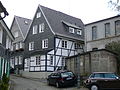
The old town of Gräfrath is located in the bottom of a valley between the Roßkamper Höhe in Wuppertal and the Gräfrather Parkfriedhof in the direction of Solingen, off the Wuppertaler Straße built in 1934, today's federal road 224 . The town center, which is medieval in its basic structure , presents itself with its buildings as a small Biedermeier mountain town from the beginning of the 18th century. Left and right of the cobbled streets are mostly two or three-story, slated half-timbered houses of the Bergisch style . For this building tradition, the black painting of the stud work, the white painting of the window and door frames, the liming of the compartments, the green painting of the shutters and doors and the use of Rhenish slate for wall cladding are common. Often only the weather side of the building was initially slated; Wealthy builders, however, afforded their houses to be slated on all sides early on. The air raids on Solingen in November 1944 passed the town center almost without a trace, so that there was little damage from bombs.
Gräfrath's cultural center is the centrally located market square at the foot of the Klosterberg, with the towering Catholic parish church of St. Mary of the Assumption , which was rebuilt in the Baroque style after the great city fire of 1686 and another fire in 1717. The 13th century portal of one of their predecessor buildings was also used. At the rear of the church are the large-volume monastery buildings.
A few dozen steps below the church, following the church staircase, you get to the market square, which was redesigned at the beginning of the 20th century. The well, which does not reach the groundwater, but is a basin that collects the water from the Itter stream, dates from 1957 and imitates the previous building from the first half of the 18th century. Many of the buildings on Gräfrather Markt have retrospectively installed shop fittings from the 19th or 20th century. The Protestant church, built in 1688 on the corner of Gerberstrasse, stands out as a simple, plastered hall with a baroque tower.
The course of the former city wall around the market square can still be traced today using the streets Täppken, Am Graben and Am Wall. However, the fortification was gradually removed after 1686 and the areas that were freed as a result were largely built on. Remnants of the wall are still in the Gasse Am Wall, as is an old coat of arms stone from 1654.
The street In der Freiheit was the former thoroughfare through the town. The tram between Solingen and Wuppertal also ran here from 1898 until the Second World War . In the course of this, two buildings on the corner of Graefrather Markt and Küllersberg had to be demolished because the radius of the curve was too tight. In return, a massive, three-story Art Nouveau residential building was built on the corner, which apparently stands out from the surrounding structures. In the massive building In der Freiheit 27, built in 1859, was the operating room of the ophthalmologist De Leuw. In the streets In der Freiheit and Walder Straße there are also four villas, some of which were built in the Swiss country house style in the second half of the 19th century.
The Garrisonstraße, which is named after a Landwehr battalion formerly located there, is also part of the historic town center. It connects the market square in the north with the former fire pond. The Oberhaaner Strasse and the manorial Bergische patrician house on it are also part of the historic district.
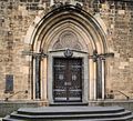
Portal of the Catholic parish church
Development on Gräfrather Markt / church stairs
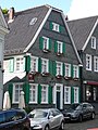
House on the Graefrather market

View over the Graefrath market

The Protestant church on the market square
Täppken street
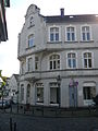
The building on Küllersberg, erected after the tram was built


Culture and sights

Attractions
The historic town center around the market square in Gräfrath, with around 90 monuments along the streets Am Graben, Am Wall, In der Freiheit, Garnisonstraße, Gerberstraße, Gräfrather Markt, Kirchtreppe, Klosterhof, Küllersberg, Steines, Täppken and Walder Straße, is one of the 56 selected historical streets Town centers in North Rhine-Westphalia .
The Grünewald house is located a few hundred meters to the north as the crow flies, before the city limits of Wuppertal-Vohwinkel . The country house with an English garden is popularly known as Grünewald Castle because of its size . It is privately owned and is rented out as an event location.
The Fauna zoo is also just a stone's throw from the town center . As one of two zoos in Solingen, the fauna is home to around 500 animals of 116 different species.


Churches
There are a total of four churches in the Gräfrath district. The Catholic parish church at the cloister courtyard ( St. Mariä Himmelfahrt ) and the Protestant church at Gräfrather Markt are located in the historic center of the district. In addition, there is the Protestant church Ketzberg including cemetery and cemetery chapel in the east of the city district on Lützowstrasse. The church was consecrated in 1873 and the cemetery chapel was built around 1896. The Catholic parish church of St. Michael is on Schlagbaum (Schlagbaumer Straße). The building, inaugurated in 1958, is the youngest of the four Gräfrath churches.
Museums
The German Blade Museum , which is housed in the former women's monastery in the town center of Gräfrath, shows an extensive collection of cutlery , knives and edged weapons from the Bronze Age to the present day. The city of Solingen has always been the center of the German cutlery industry, high quality blades made in Solingen have been sold all over the world since the Middle Ages. In addition, the museum keeps the Gräfrath church treasure in its own collection, which dates from the time of the monastery. In the basement of the monastery building there is also the Gräfrath Museum , which was set up in 2005 on the initiative of the Solingen-Gräfrath Heimatverein.
In the former town hall of Gräfrath, the Art Museum Solingen , which was called Museum Baden until 2011 , shows works of art primarily by regional, Bergisch and Solingen artists, such as Georg Meistermann . Germany's first center for persecuted arts started its work within the museum on January 1st, 2015 .
Film set
In 2011, Gräfrath was the idyllic setting for the ARD film Learn to Fly with Gesine Cukrowski . Outside shots for the feature films The World Is Alright (1968) and When the Moonlight Sleeps Sweetly on the Hills (1969) have also been shot on the market square . Other recordings for the films were made in the Walder Bausmühle .
Others
The Central Technical School of the German Confectionery Industry (ZDS) was inaugurated on the outskirts of the Graefrath town center in 1954. The ZDS has been renting the nearby youth hostel for two years as a dormitory for its trainees since August 2015 . The youth hostel opened in 1962 and was last threatened with closure.
Personalities
- Johann Abraham von den Steinen († 1814), doctor
- Friedrich Hermann de Leuw (1792–1861), doctor
- August Schnitzler (1794–1861), entrepreneur
- Friedrich August de Leuw (1817–1888), artist
- Louis de Leuw (1819-1858), doctor
- Carl Meurer (1832–?), Doctor
- Albert Pütz (1886–1961), painter
- Dr. Carl Wilhelm Wiedenfeld, evangelical pastor
See also
- List of the historic town centers in North Rhine-Westphalia
- List of architectural monuments in Solingen-Gräfrath
- Honschaft Graefrath
- Mayor's Office Graefrath
literature
- W. Brenner, K. Bremes: On the history of the city of Gräfrath , Verlag der Stadt Gräfrath, Gräfrath 1920
- The great oculist or all about Graefrath . - London: Hatchard & Co., 1859. Digitized edition of the University and State Library Düsseldorf
- Gräfrath, the abbey and the city: a walk through eight centuries . Voß, Düsseldorf 1883 ( digitized edition )
- Lutz Peters: Graefrath. Walks in History , ed. from the Bergisches Geschichtsverein department Solingen e. V., updated new edition 2014, Solingen 2012.
Web links
Individual evidence
- ↑ http://www.historische-stadt-ortskerne-nrw.de/Stadtkerne/portrait.php?stadt=46 Web presence of the district on historic-stadt-ortskerne-nrw.de , accessed on December 27, 2014
- ↑ a b c d e f g h i j k l m n o p q W. Benner, K. Bremes: On the history of the city of Gräfrath . Publishing house of the city of Gräfrath, Gräfrath 1920.
- ^ Heinz Rosenthal: Solingen. History of a city . Volume 1: From the beginning to the end of the 17th century. Braun, Duisburg 1969, DNB 457973358 .
- ↑ Rheinischer Städteatlas Ohligsberg ; Lfg. XII No. 66, 1996; Editor: Elisabeth Reuß; Rhineland publishing house Cologne
- ^ A b Heinz Rosenthal: Solingen. History of a City , Volume 2, Walter Braun Verlag, Duisburg 1972, ISBN 3-87096-103-1
- ^ History of the sports field on bv-graefrath.de , accessed on June 5, 2015.
- ↑ Timeline of the history of Solingen ( Memento of the original from December 27, 2014 in the Internet Archive ) Info: The archive link was inserted automatically and has not yet been checked. Please check the original and archive link according to the instructions and then remove this notice. on solingen.de , accessed on December 27, 2014.
- ↑ 150 years of gas supply in Solingen 1859–2009, p. 10f ( page no longer available , search in web archives ) Info: The link was automatically marked as defective. Please check the link according to the instructions and then remove this notice. (PDF; 818 kB)
- ^ A b Heinz Rosenthal: Solingen. History of a City , Volume 3, Walter Braun Verlag. Duisburg 1975, ISBN 3-87096-126-0
- ↑ 125 years of central water supply in Solingen 1883–2008 p. 8f ( page no longer available , search in web archives ) Info: The link was automatically marked as defective. Please check the link according to the instructions and then remove this notice. (PDF; 1.3 MB)
- ↑ Lutz Peters: Gräfrath - as it used to be , Wartberg Verlag, Gudensberg-Gleichen 2001, pp. 61–65
- ↑ Background information on vaillant.de , accessed on June 4, 2015
- ↑ http://www.zeitspurensuche.de/02/sgogra1.htm Description of coat of arms on zeitspurensuche.de, accessed on February 15, 2015.
- ^ Marina Alice Mutz: Mayor of Solingen. In: Time Track Search. Retrieved March 26, 2016 .
- ↑ Age groups city districts ( Memento of the original from March 13, 2014 in the Internet Archive ) Info: The archive link was automatically inserted and not yet checked. Please check the original and archive link according to the instructions and then remove this notice. (PDF; 6 kB)
- ↑ http://www.zeitspurensuche.de/02/kirchsg3.htm Brief overview of the church buildings in Gräfrath on zeitspurensuche.de , accessed on December 29, 2014
- ↑ Archived copy ( Memento of the original from May 5, 2015 in the Internet Archive ) Info: The archive link was inserted automatically and has not yet been checked. Please check the original and archive link according to the instructions and then remove this notice. at Heimatverein Solingen-Gräfrath e. V., accessed on May 22, 2015
- ^ Report of the Solinger Morgenpost from January 6, 2015, accessed on May 22, 2015
- ^ Report of the Jüdischen Allgemeine from January 8, 2015, accessed on May 22, 2015
- ↑ History of the ZDS ( Memento of the original from May 28, 2015 in the Internet Archive ) Info: The archive link was inserted automatically and has not yet been checked. Please check the original and archive link according to the instructions and then remove this notice. at zds-solingen.de, accessed on May 22, 2015
- ^ Report of the Solinger Morgenpost from March 2, 2015, accessed on May 22, 2015
- ↑ Pictures to Flockertsholz, Friedenstal u. a. from bilder-von-solingen.de , accessed on May 22, 2015
- ^ Report of the Solinger Morgenpost from January 13, 2015, accessed on May 22, 2015