II. Stockdum
|
II. Stockdum
City of Solingen
Coordinates: 51 ° 11 ′ 3 ″ N , 7 ° 4 ′ 57 ″ E
|
||
|---|---|---|
| Height : | about 225 m | |
| Postal code : | 42653 | |
| Area code : | 0212 | |
|
Location of II. Stockdum in Solingen |
||
|
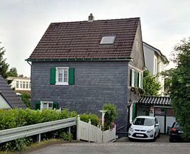
Residential building on the 2nd floor
|
||
II. Stockdum is a court in the Bergisch city of Solingen .
geography
II. Stockdum is located north of Schlagbaum on the western edge of the Bärenloch green and leisure facility in the Gräfrath district of Solingen, right on the border with Solingen-Mitte . To the southwest is the yard I. Stockdum and north of the III. Stick dumb .
etymology
It is widely accepted that the term stockdum is derived from the word stockden; this hall name is also used in Remscheid , for example . There are also variations in Solingen, for example in the place name Stöcken . This probably means the root stocks left behind after felling or clearing , where the yard was created.
history
The roots of one of the three Stockdum farms are believed to be at least at the beginning of the 14th century. In 1303 a Stockede farm is mentioned as belonging to the Lüntenbeck farm near Elberfeld . Stockdum is said to have been the preferred residence of a certain group of blade craftsmen, namely the butcher and bread knife riders .
In the map by Erich Philipp Ploennies from 1715, only a total of two farms with the name Stocktum are recorded. The topographical survey of the Rhineland from 1824 lists the place together with the first stockdum as stockdums, on the Prussian first survey of 1844 the second stockdum is already used . In the topographical map of the Düsseldorf administrative district from 1871, the courtship is also recorded together with the first stockdum as a stockdum .
After the Mairien and later mayor's offices were founded at the beginning of the 19th century, the court belonged to the Gräfrath mayor's office . Around 1815, the old road from Vohwinkel via Gräfrath to Solingen was expanded into the Essen – Solingen Provincial Road, today's federal road 224, which was led over a dam at I. Stockdum.
In 1815/16, 171 inhabitants lived in all of the Stockdum residential areas, and in 1830 there were 201 inhabitants in the place called the hamlet. In 1832 the three Stockdumer living spaces were still part of the Honschaft (Ketz-) Berg within the Gräfrath mayor's office. The three residential areas, categorized as Hofstadt according to the statistics and topography of the administrative district of Düsseldorf, had a total of 29 residential buildings, eleven factories or mills and 25 agricultural buildings in 1832. At that time there were 255 residents in the village, 34 of whom were Catholic and 221 Protestant. The municipal and estate district statistics of the Rhine Province list the three residential places in 1871 together with 56 residential buildings and 431 inhabitants. In the parish lexicon for the Rhineland province in 1885, 31 houses with 217 inhabitants were given for the first floor . In 1895 the place had 34 houses with 184 inhabitants, in 1905 34 houses and 256 inhabitants are given.
With the town union of Groß-Solingen in 1929, the II. Stockdum became a district of Solingen. In the course of a restructuring of the court names as street names in the Solingen city area in 1976, the name II. Stockdum was partially deleted as a street name and replaced by Ingridweg.
swell
- ↑ Hans-Georg Wenke: Place and street names. In: solingen-internet.de. Retrieved May 21, 2016 .
- ↑ a b Marina Alice Mutz: Stockdum. In: Time Track Search. Retrieved May 21, 2015 .
- ^ Heinz Rosenthal: Solingen. History of a city, from the beginning to the end of the 17th century. Volume 1. Verlag Braun, Duisburg 1969, p. 36, DNB 457973358
- ^ Topographic map of the Düsseldorf administrative district . Designed and executed according to the cadastral recordings and the same underlying and other trigonometric work by the Royal Government Secretary W. Werner. Edited by the royal government secretary FW Grube. 4th rev. Edition / published by A. Bagel in Wesel, 1859 / Ddf., Dec. 17, 1870. J. Emmerich, Landbaumeister. - Corrected after the ministerial amendments. Ddf. d. Sept. 1, 1871. Bruns.
- ↑ a b Friedrich von Restorff: Topographical-statistical description of the Royal Prussian Rhine Province . Nicolaische Buchhandlung, Berlin / Stettin 1830 ( digitized ).
- ↑ a b Johann Georg von Viebahn : Statistics and topography of the administrative district of Düsseldorf . 1836
- ^ The communities and manor districts of the Rhine Province and their population. Edited and compiled by the Royal Statistical Bureau from the original materials of the general census of December 1, 1871. In: Königliches Statistisches Bureau (Hrsg.): The communities and manor districts of the Prussian state and their population. tape XI , 1874, ZDB -ID 1467523-7 ( digitized ).
- ^ Community encyclopedia for the province of Rhineland. Based on materials from the census of December 1, 1885 and other official sources, edited by the Royal Statistical Bureau. In: Royal Statistical Bureau (Hrsg.): Community encyclopedia for the Kingdom of Prussia. tape XII , 1888, ZDB -ID 1046036-6 ( digitized version ).
- ^ Community encyclopedia for the province of Rhineland. Based on materials from the census of December 1, 1895 and other official sources, edited by the Royal Statistical Bureau. In: Royal Statistical Bureau (Hrsg.): Community encyclopedia for the Kingdom of Prussia. tape XII , 1897, ZDB -ID 1046036-6 .
- ^ Community encyclopedia for the Rhine Province. Based on the materials from the census of December 1, 1905 and other official sources, edited by the Royal Prussian State Statistical Office. In: Königliches Prussisches Statistisches Landesamt (Hrsg.): Community encyclopedia for the Kingdom of Prussia. Booklet XII, 1909, ZDB -ID 1046036-6 .

