
Külf (Solingen)
|
Külf
City of Solingen
Coordinates: 51 ° 11 ′ 31 ″ N , 7 ° 5 ′ 40 ″ E
|
||
|---|---|---|
| Height : | about 155 m | |
| Postal code : | 42653 | |
| Area code : | 0212 | |
Location of Külf in Solingen |
||
 Külf
|
||

Külf is a court in the Gräfrath district of Solingen .
geography
Külf is located in the sloping areas to the Wupper south-east of Ketzberg in the south-eastern part of the Gräfrath district, on the border with the Mitte district . The Hofschaft is located on the banks of the Külfer Bach , which rises from the Hofschaft Busch to the west and flows into the Wupper near Kohlfurth . To the north of Külf are Rathland and Schafenhaus , to the east the Fleußmühle and the Altenfeld and Schrodtberg farms and to the south the Bärenloch leisure and park complex with the garbage dump on the edge .
etymology
The origin of the court name has not been conclusively clarified. According to Brangs, the word is a diminutive of the word Kohlfurth . According to other sources, the words Kolf, Kolve or Külf mean water hole, the Hofschaft Külf lies on the bank of a brook.
history
The Hofschaft Külf was first mentioned in a document in 1672 when there is talk of Heinrich Moum living in the Külf. In the map series Topographia Ducatus Montani by Erich Philipp Ploennies , Blatt Amt Solingen , from the year 1715, the place is recorded with a farm and named as Kölf . The farm belonged to the Ketzberg Honschaft within the Solingen office. The topographical survey of the Rhineland from 1824 lists the place as in the Költ and the Prussian first survey of 1844 as Külf. In the topographic map of the Düsseldorf administrative district from 1871, the court is recorded as Külf .
After the Mairien and later mayor's offices were founded at the beginning of the 19th century, Altenfeld belonged to the Gräfrath mayor's office . In 1815/16 there were 52 people living in the village, in 1830 62 people lived in the place known as the establishment . In 1832, Külf was still part of the (Ketz-) Berg community within the Gräfrath mayor. The place, categorized as Hofstadt according to the statistics and topography of the administrative district of Düsseldorf , had eight residential buildings, seven factories or mills and eight agricultural buildings at that time. At that time, 71 residents lived in the village, four of them Catholic and 67 Protestant. The municipality and estate district statistics of the Rhine Province list the place in 1871 with 14 houses and 82 inhabitants. In the municipality lexicon for the Rhineland province in 1885, 14 houses with 75 inhabitants are given. In 1895 the district had 13 houses with 82 inhabitants, in 1905 eleven houses and 64 inhabitants are given.
With the town union of Groß-Solingen in 1929, the Külf court became a district of Solingen. The historic half-timbered ensemble at house numbers 21, 23, 25 has been a listed building in Külf since 1984 .
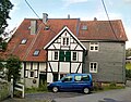
Main courtyard house Külf 21, 23, 25

Main courtyard house Külf 21, 23, 25 (back side)


Web links
swell
- ↑ a b Hans Brangs: Explanations and explanations for the corridor, place, yard and street names in the city of Solingen . Solingen 1936
- ^ Wolfgang Stock: Wuppertal street names . Thales Verlag, Essen-Werden 2002, ISBN 3-88908-481-8
- ^ Topographic map of the Düsseldorf administrative district . Designed and executed according to the cadastral recordings and the same underlying and other trigonometric work by the Royal Government Secretary W. Werner. Edited by the royal government secretary FW Grube. 4th rev. Edition / published by A. Bagel in Wesel, 1859 / Ddf., Dec. 17, 1870. J. Emmerich, Landbaumeister. - Corrected after the ministerial amendments. Ddf. d. Sept. 1, 1871. Bruns.
- ↑ a b Friedrich von Restorff : Topographical-statistical description of the Royal Prussian Rhine Province . Nicolai, Berlin / Stettin 1830
- ↑ a b Johann Georg von Viebahn : Statistics and topography of the administrative district of Düsseldorf . 1836
- ^ The communities and manor districts of the Rhine Province and their population. Edited and compiled by the Royal Statistical Bureau from the original materials of the general census of December 1, 1871. In: Königliches Statistisches Bureau (Hrsg.): The communities and manor districts of the Prussian state and their population. tape XI , 1874, ZDB -ID 1467523-7 ( digitized ).
- ^ Community encyclopedia for the province of Rhineland. Based on materials from the census of December 1, 1885 and other official sources, edited by the Royal Statistical Bureau. In: Royal Statistical Bureau (Hrsg.): Community encyclopedia for the Kingdom of Prussia. tape XII , 1888, ZDB -ID 1046036-6 ( digitized version ).
- ^ Community encyclopedia for the province of Rhineland. Based on materials from the census of December 1, 1895 and other official sources, edited by the Royal Statistical Bureau. In: Royal Statistical Bureau (Hrsg.): Community encyclopedia for the Kingdom of Prussia. tape XII , 1897, ZDB -ID 1046036-6 .
- ^ Community encyclopedia for the Rhine Province. Based on the materials from the census of December 1, 1905 and other official sources, edited by the Royal Prussian State Statistical Office. In: Königliches Prussisches Statistisches Landesamt (Hrsg.): Community encyclopedia for the Kingdom of Prussia. Booklet XII, 1909, ZDB -ID 1046036-6 .
- ↑ Solingen Monument List. ( Memento of the original from December 18, 2015 in the Internet Archive ) Info: The archive link was inserted automatically and has not yet been checked. Please check the original and archive link according to the instructions and then remove this notice. (PDF; 129 kB) City of Solingen, July 1, 2015; Retrieved June 5, 2016.
Altenfeld | Apple tree | Aue | Belt mill | Bergerbrühl | Bimerich | Flower valley | Bush | Buscher field | Third Kotten | Dyck | Corner stump | Egidius Klusen | Honor | Flockertsberg | Flockert wood | Foche | Focher Dahl | Freudenberg | Peace Valley | Grünewald | Reason | Heather | Heider Hof | Ketzberg | Kohlfurther Eickholz | Külf | Laiken | Mühlenbusch | Neuenhaus | New bull | Nümmen | Obenflachsberg | Up to the wood | Paashaus | Piepersberg | Rauenhaus | Rathland | Ringhouse | Sheep House | Schieten | Turnpike | Scheiderirlen | Schönhof | Steinbeck | Stone house | Stone sieving | Stöckerberg | I. Stockdum | II. Stockdum | III. Stockdum | Tummelhaus | Unterflachsberg | Down to the wood | Central | Ziegelfeld (East) | Ziegelfeld (south)