Turnpike (Solingen-Mitte)
|
Turnpike
City of Solingen
Coordinates: 51 ° 10 ′ 51 ″ N , 7 ° 4 ′ 51 ″ E
|
||
|---|---|---|
| Height : | about 230 m | |
| Postal code : | 42651 | |
| Area code : | 0212 | |
|
Location of Schlagbaum in Solingen |
||
|
Turnpike
|
||
Schlagbaum is a residential area in the Mitte district of the Bergisch city of Solingen . The intersection at Schlagbaum is one of the busiest traffic hubs in the city today .
geography
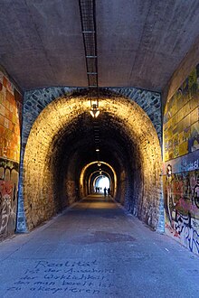
Schlagbaum is located north of Solingen city center on the edge of the Gräfrath district in the north of Solingen . To the north are courtyards I. and II. Stockdum . Today, Schlagbaum is the name of the area around the busy intersection of Bundesstraße 224 and Landesstraße 141 or Kuller Straße, which later leads as Landesstraße 427 via Kohlfurth to Wuppertal - Cronenberg . To the east of the turnpike is the Neuenkulle residential area , to the west is the Untenscheidt estate . The 109-meter-long barrier tunnel , a former railway tunnel, which is now part of the corkscrew route, passes under the barrier .
etymology
The living space barrier takes its name from a formerly located there turnpike .
history
In the map series Topographia Ducatus Montani by Erich Philipp Ploennies , Blatt Amt Solingen , from the year 1715, the location of Schlagbaum is not yet recorded, but the street intersection is. The residential area was not built until after 1715 and in the early days as a border town belonged partly to the Honschaft Ketzberg , partly to the Honschaft Scheid and partly to the foreign citizenship of the city of Solingen, all in the Bergisch Amt Solingen. The topographical survey of the Rhineland from 1824 lists the place as am Schlagbaum, the Prussian first survey from 1844 as Gr. Turnpike. To the northwest, the Neuenkulle residential area is labeled with Kl. Schlagbaum . In the topographic map of the Düsseldorf administrative district from 1871, the place is recorded as a turnpike .
From north to south, the old road led from Vohwinkel via Gräfrath to Solingen through the village, which was expanded to the provincial road Essen – Solingen around 1815 , today's federal road 224. Shortly before Schlagbaum, an older coal road opened up, a transport route for, among other things Hard coal from the mining areas of the southern Ruhr area, which ran as the Höhenweg (today Lützowstraße) east of Gräfrath from the Wuppertal to Solingen. The Solingen control point for these two traffic routes was on the same route at Schlagbaum before reaching the city.
In the 19th century, Schlagbaum was the border town between the mayor's office of Gräfrath , the mayor's office of Wald and the mayor's office of Solingen. The settlement of the residential area took place on both sides of the municipality borders, so that there was a Graefather, a forest and a Solingen suburb.
In 1815/16 6 people lived in Gräfrather, 14 in the forest and 38 in the Solingen district. In 1830 54 people (6 in Gräfrath, 17 in Wald and 41 in Solingen) lived in Schlagbaum. In 1832 the place was still part of the Honschaft (Ketz-) Berg within the mayor of Gräfrath, the second village honors within the mayor of Wald and the external citizenship of the city of Solingen, which, according to the statistics and topography of the Düsseldorf administrative district, was categorized as arable land and factory apartments or as a court town At that time, Ort owned 21 houses (one in Gräfrath, 16 in Wald and four in Solingen) and eleven agricultural buildings (two in Gräfrath, six in Wald and three in Solingen). At that time, 96 residents lived in the village (eleven in Graefrath, 65 in Wald and 20 in Solingen), of which 31 were Catholic and 65 Protestant. The municipality and estate district statistics of the Rhine Province lists the place in 1871 with 79 residential houses (eight in Graefrath, 67 in Wald and four in Solingen) and 680 inhabitants (92 in Graefath, 543 in Wald and 45 in Solingen). In the municipality lexicon for the Rhineland province of 1888, 105 houses with 792 inhabitants (87 for Graefath and 705 for Wald) are given. In 1895 the district had 14 houses with 144 inhabitants (only Gräfrath and Solingen, no information for forest), in 1905 20 houses and 162 inhabitants were given (only Gräfrath and Solingen).
In 1887 the barrier for the Solingen – Wuppertal-Vohwinkel railway line was tunnelled over a total of 92 meters . In the course of the expansion of the crossroads above, the tunnel was lengthened by 17 meters in 1978, so that it reached its current length of 109 meters.
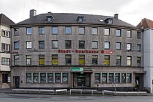
Solingen's first own tram route from Stöckerberg led over the turnpike and the city center to the Südbahnhof and was opened on June 2, 1897. Over the years the traffic situation at the narrow traffic junction worsened because the traffic increased steadily. With the city association of Groß-Solingen in 1929, the turnpike became a district of Solingen. As one of the first construction projects in the new city, the expansion of the Schlagbaum intersection was tackled in May and June 1930. The tram tracks in the direction of Vohwinkel and Ohligs were laid on two tracks. On October 1, 1934, the post office opened on Schlagbaum, and on July 14, 1936, the new Stadtsparkasse opened on Schlagbaum.
With the increase in individual traffic after the Second World War, the traffic situation at the turnpike intensified after the abolition of tram traffic in 1959. The first traffic light on the turnpike was inaugurated in 1952. However, there is no money for a large-scale expansion with the demolition of the buildings on the corner of Kuller Strasse and Kronprinzenstrasse. In 1960 a small solution to the renovation was therefore chosen. Central islands were created and the bus stops partially relocated, the Ohligs trolleybus received its own contact wire to shorten its travel time around the curve.
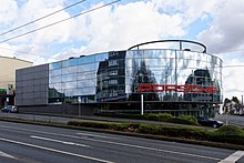
From the mid-1970s, the traffic situation became increasingly precarious despite the ongoing renovations. So the big solution was finally implemented and in 1978 the renovation began with widening the intersection, for which some surrounding buildings on Kuller Strasse and Kronprinzenstrasse had to give way. Among them was the so-called Fischerhaus, a Bergisches patrician house from 1761, which was stored in individual parts in order to enable it to be relocated to another location. However, this never happened and the half-timbered beams rotted away at their temporary storage facility at the Poschheider mill . The Porsche Center is now located at the former location of the Fischerhaus. With the opening of the new town hall in 2008, the bus stop was renamed from Schlagbaum to Rathausplatz.
swell
- ^ Topographic map of the Düsseldorf administrative district . Designed and executed according to the cadastral recordings and the same underlying and other trigonometric work by the Royal Government Secretary W. Werner. Edited by the royal government secretary FW Grube. 4th rev. Edition / published by A. Bagel in Wesel, 1859 / Ddf., Dec. 17, 1870. J. Emmerich, Landbaumeister. - Corrected after the ministerial amendments. Ddf. d. Sept. 1, 1871. Bruns.
- ^ A b Friedrich von Restorff : Topographical-statistical description of the Royal Prussian Rhine Province , Nicolai, Berlin and Stettin 1830
- ↑ a b Johann Georg von Viebahn : Statistics and Topography of the Administrative District of Düsseldorf , 1836
- ↑ Royal Statistical Bureau Prussia (ed.): The communities and manor districts of the Prussian state and their population . The Rhine Province, No. XI . Berlin 1874.
- ↑ Königliches Statistisches Bureau (Prussia) (Ed.): Community encyclopedia for the Rhineland Province, based on the materials of the census of December 1, 1885 and other official sources, (Community encyclopedia for the Kingdom of Prussia, Volume XII), Berlin 1888.
- ↑ Königliches Statistisches Bureau (Prussia) (Ed.): Community encyclopedia for the Rhineland Province, based on the materials of the census of December 1, 1895 and other official sources, (Community encyclopedia for the Kingdom of Prussia, Volume XII), Berlin 1897.
- ↑ Königliches Statistisches Bureau (Prussia) (Ed.): Community encyclopedia for the Rhineland Province, based on the materials of the census of December 1, 1905 and other official sources, (Community encyclopedia for the Kingdom of Prussia, Volume XII), Berlin 1909.
- ↑ Lother Brill: Turnpike tunnel. In: eisenbahn-tunnelportale.de. Retrieved June 6, 2016 .
- ↑ a b c Ralf Rogge, Armin Schulte, Kerstin Warncke: Solingen - Big City Years 1929-2004 . Wartberg Verlag, 2004, ISBN 3-8313-1459-4
- ^ Solinger Morgenpost: Invoice with unknown people. November 25, 2008. Retrieved May 25, 2016 .


