
Kleinenberg (Solingen)
|
Kleinenberg
City of Solingen
Coordinates: 51 ° 10 ′ 39 ″ N , 7 ° 3 ′ 22 ″ E
|
||
|---|---|---|
| Height : | about 195 m | |
| Postal code : | 42719 | |
| Area code : | 0212 | |
Location of Kleinenberg in Solingen |
||
 Kleinenberg
|
||

Kleinenberg is a residential area in the Bergisch city of Solingen .
geography
Kleinenberg is located on a southern slope of the Lochbachtal in the Solingen district of Mitte near the border with Wald . The place is located between the Dältgenstal in the north and the Zeppelinstraße in the south on the Kleinenberger Straße named after the place as well as the small strait with the name of the place. The banks of the Lochbach, which runs in an east-west direction and flows northwest of Kleinenberg past the Scheider Mühle, are also located in the Düllegen Valley . To the west of Kleinenberg lies Büschberg , to the south on the crest of the ridge between Lochbach and Viehbach on Beethovenstrasse lies Dingshaus . The Hofschaft Lehn lies in the east .
etymology
The field name Kleinenberg may actually refer to the small mountain up from the Lochbachtal, on which the former farm was built. The name of the Hofschaft used to be Am Kleinenberg .
history
Kleinenberg has been proven since the 16th century. In 1650 a Johann Broch am Kleinenberg is mentioned in the baptismal registers of the Protestant community of Wald . In 1715 in the map Topographia Ducatus Montani , Blatt Amt Solingen , by Erich Philipp Ploennies , the place is recorded with a farm and named as Kl. Berg . The court belonged to the Scheid Honschaft within the Solingen office. The topographical survey of the Rhineland from 1824 lists the place as Kleineberg and the Prussian first survey from 1844 as Kleinenberg . In the topographic map of the Düsseldorf administrative district from 1871, the courtyard is also listed as Kleinenberg .
After the Mairien and later mayor's offices were founded at the beginning of the 19th century, the farm belonged to the forest mayor's office . In 1815/16 46 people lived in the hamlet of Kleinenberg , in 1830 51 people . In 1832 the place was part of the Second Dorfhonschaft within the mayor's office forest, there it was in the corridor III. ( Scheid ). The place, which was categorized as a Hofstadt according to the statistics and topography of the Düsseldorf administrative district , had nine residential buildings and nine agricultural buildings at that time. At that time, 52 residents lived in the village, six of them Catholic and 42 Protestant. The municipality and estate district statistics of the Rhine Province list the place in 1871 with 13 houses and 92 inhabitants. In the municipality lexicon for the Rhineland province of 1888, 14 houses with 93 inhabitants are given for Kleinenberg. In 1895 the district had 14 houses with 91 inhabitants, in 1905 nine houses and 62 inhabitants are given.
With the city association of Groß-Solingen in 1929, Kleinenberg became a district of Solingen. According to today's city district boundaries, Kleinenberg belongs to Solingen-Mitte.
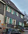
Slated half-timbered house in Kleinenberg

Front door with door inscription in Kleinenberg


Web links
swell
- ↑ a b Hans Brangs: Explanations and explanations of the hall, place, yard and street names in the city of Solingen , Solingen 1936
- ^ City of Solingen: Street and place names in our city of Solingen , self-published, Solingen 1972
- ^ Topographic map of the Düsseldorf administrative district . Designed and executed according to the cadastral recordings and the same underlying and other trigonometric work by the Royal Government Secretary W. Werner. Edited by the royal government secretary FW Grube. 4th rev. Edition / published by A. Bagel in Wesel, 1859 / Ddf., Dec. 17, 1870. J. Emmerich, Landbaumeister. - Corrected after the ministerial amendments. Ddf. d. Sept. 1, 1871. Bruns.
- ↑ a b c Johann Georg von Viebahn : Statistics and Topography of the Düsseldorf Government District , 1836
- ↑ Friedrich von Restorff : Topographical-statistical description of the Royal Prussian Rhine Province , Nicolai, Berlin and Stettin 1830
- ↑ Royal Statistical Bureau Prussia (ed.): The communities and manor districts of the Prussian state and their population . The Rhine Province, No. XI . Berlin 1874.
- ↑ Königliches Statistisches Bureau (Prussia) (Ed.): Community encyclopedia for the Rhineland Province, based on the materials of the census of December 1, 1885 and other official sources, (Community encyclopedia for the Kingdom of Prussia, Volume XII), Berlin 1888.
- ↑ Königliches Statistisches Bureau (Prussia) (Ed.): Community encyclopedia for the Rhineland Province, based on the materials of the census of December 1, 1895 and other official sources, (Community encyclopedia for the Kingdom of Prussia, Volume XII), Berlin 1897.
- ↑ Royal Statistical Bureau (Prussia) (Ed.): Community encyclopedia for the Rhineland Province, based on the materials of the census of December 1, 1905 and other official sources, (Community encyclopedia for the Kingdom of Prussia, Volume XII), Berlin 1909
Adamsfeld | Altenhof | Backesheide | Bauskotten | Bausmühle | Buckert | Büschberg | Buxhaus | Dent | Demmeltrath | Thing house | Dorpskotten | Duldgenstal | Ehrener mill | Own | Own mountain | Own field | Egg passport | Eschbach | Fields yard | Fürkeltrath | Drove | Frisian house | Goodness | Rooster House | Hedges | Heidufer | Henshaus | Hostel | Height | Wood | Hedgehog forest | Itterberg | Itterbruch | Kleinenberg | Knynsbusch | Pukes | Puked sticks | Scratch pads | Frills | Way of the Cross | Lauterjungskotten | Lehn | Lindersberg | Hole | Punch hammer | Lochskotten | Corn oak | Mittelgönrath | Middle knight | Mummenscheid | New Egg Pass | Neuenkotten | Obengönrath | Top nitter | Obenmangenberg | Obenscheidt | Rolsberg | Turnpike | Scheider mill | Scheiderfeld | Scouring | Schneppert | Sonnenkamp | Sunshine | Worry House | Stübben | Shrub | Deep Thick | Untengönrath | Bottom sitter | Untermangenberg | Untenscheidt | Vogelsang | Forest | Waldheim | Westersburg | Wiedenhof | Wiedenkamp | Reflection | Wittkulle | Target cabins