Duldgenstal
|
Duldgenstal
City of Solingen
Coordinates: 51 ° 10 ′ 48 ″ N , 7 ° 3 ′ 23 ″ E
|
||
|---|---|---|
| Height : | about 170 m | |
| Postal code : | 42719 | |
| Area code : | 0212 | |
|
Location of Düllegenstal in Solingen |
||
|
Duldgenstal
|
||
Dältgenstal is a residential area in the Wald district of the Bergisch city of Solingen .
geography
Dältgenstal is located in the Lochbachtal in the south-east of the forest center. The place is mainly located on Dältgenstaler Straße, named after the place where you lived, in the valley floor on the banks of the Lochbach. The former factory of the Dülle brothers is located between Lehner and Brucknerstrasse. Landesstraße 85 runs along the ridge in the north, which in this area bears the names Liebermann- and Ernst-Barlach-Straße, and the Scheiderfeld homestead is also located there . To the south and south-east are the Scheider Mühle , Büschberg and Kleinenberg . The Hofschaft Lehn lies on a hill in the east , while Eigen and Eigener Berg are in the northeast .
etymology
The place name Dältgenstal comes from the family name Dältgen. The Dülgen brothers settled in the local part of the Lochbach valley and founded a factory there. The entire section of the valley was then given the name Dältgenstal , initially in the vernacular and later officially .
history
The transition to the age of industrialization in the entire Solingen area took place at the end of the 1820s, among other things in what is now Dältgenstal. The Dülgen brothers, who came from Herberg , started manufacturing umbrella fittings at this time . To this end, in 1830 half and later the entire Ernenkotten in Lochbachtal was bought up. The brothers initially worked with hydropower . In addition to the manufacture of umbrella frames, the production of bag hangers (i.e. the snap-lock edging of wallets or handbags ) was added later. From the middle of the 19th century, the factory area on the banks of the Lochbach continued to grow and modern factory buildings were built.
From the first half of the 19th century, a few residential buildings, mostly two-story half - timbered houses, were built at the factory . The Duldgenstal residential area belonged to the mayor's office in Wald . The topographical survey of the Rhineland from 1824 does not yet record the place, the Prussian first survey of 1844 records it and names it as Unt: Herberg . On the same card, today's Herberg bears the name Ob: Herberg . In the topographic map of the Düsseldorf administrative district from 1871, however, the place is not recorded. It was not until 1893 to 1895 that the place was recorded as Dältgenstal on the measuring table sheets .
The municipality and estate district statistics of the Rhine Province list the place as Düttgensthal 1871 with 26 houses and 160 inhabitants. In the municipality lexicon for the province of Rhineland from 1888, 29 houses with 167 inhabitants are given for Dältgensthal . In 1895 the district had 30 houses with 174 inhabitants, in 1905 35 houses and 268 inhabitants are given.
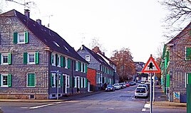
With the town union of Groß-Solingen in 1929, the Dältgenstal became a district of Solingen. In the absence of war damage, the place is still dominated by historical buildings. The half-timbered houses on Dältgenstaler Strasse, which are now slated, are characteristic. There are also some secluded half-timbered houses. The former factory of the Dülle brothers is now home to small businesses and living space. There are still a few small commercial enterprises based in Dältgenstal. Of the historic half-timbered houses in the village, the buildings Dältgenstaler Str. 100, 105 to 109, 110, 110a, 112, 111 to 117, 114, 116, 119, 121, 121a, and 123 to 127 have been under monument protection since 1984/1985 .
swell
- ↑ Hans Brangs: Explanations and explanations of the corridor, place, yard and street names in the city of Solingen , Solingen 1936
- ^ A b Heinz Rosenthal: Solingen. History of a city . From the middle of the 19th century to the end of World War II. 1975, Volume 3, Braun, Duisburg 1975, ISBN 3-87096-126-0 .
- ^ Topographic map of the Düsseldorf administrative district . Designed and executed according to the cadastral recordings and the same underlying and other trigonometric work by the Royal Government Secretary W. Werner. Edited by the royal government secretary FW Grube. 4th rev. Edition / published by A. Bagel in Wesel, 1859 / Ddf., Dec. 17, 1870. J. Emmerich, Landbaumeister. - Corrected after the ministerial amendments. Ddf. d. Sept. 1, 1871. Bruns.
- ↑ Royal Statistical Bureau Prussia (ed.): The communities and manor districts of the Prussian state and their population . The Rhine Province, No. XI . Berlin 1874.
- ↑ Königliches Statistisches Bureau (Prussia) (Ed.): Community encyclopedia for the Rhineland Province, based on the materials of the census of December 1, 1885 and other official sources, (Community encyclopedia for the Kingdom of Prussia, Volume XII), Berlin 1888.
- ↑ Königliches Statistisches Bureau (Prussia) (Ed.): Community encyclopedia for the Rhineland Province, based on the materials of the census of December 1, 1895 and other official sources, (Community encyclopedia for the Kingdom of Prussia, Volume XII), Berlin 1897.
- ↑ Royal Statistical Bureau (Prussia) (Ed.): Community encyclopedia for the Rhineland Province, based on the materials of the census of December 1, 1905 and other official sources, (Community encyclopedia for the Kingdom of Prussia, Volume XII), Berlin 1909
- ↑ Solingen Monument List ( Memento from December 18, 2015 in the Internet Archive ). City of Solingen, July 1, 2015, accessed on July 3, 2016 (PDF, size: 129 kB).

