
Top nitter
|
Top nitter
City of Solingen
Coordinates: 51 ° 11 ′ 31 ″ N , 7 ° 2 ′ 24 ″ E
|
||
|---|---|---|
| Height : | about 145 m | |
| Postal code : | 42719 | |
| Area code : | 0212 | |
Location of Obenitter in Solingen |
||
 Half-timbered house in Obenitter
|
||

Obenitter is a location in the Bergisch city of Solingen . The listed Ittertal leisure park is located in Obenitter .
geography
Obenitter is located in the Wald district of Solingen , near the border with the neighboring town of Haan . The location is on the Itter in the Ittertal named after it, which lies in a valley between sunshine and reflections on a hill in the north and on the southern ridge on which Wittkuller Straße runs. The Ittertalstraße runs parallel to Itter from Lindersberg to Unteritter through the village. Immediately to the northeast, on a hillside, is the Igelsforst village . Mittelitter is located southwest of Obenitter with the Ittertal leisure facility and the open-air ice rink and outdoor pool . To the south lie the fields Hof and Itterberg , to the east lie the Itterstausee as well as Lindersberg, Buckert and Westersburg .
etymology
The place name -itter appears in the three former courtyards Oben-, Mittel- and Unteritter. Oriented to their course, the farms are located on the Itter brook, which rises near Gräfrath and flows into the Rhine in Düsseldorf - Urdenbach and which is documented as Ytter in 1218/31 and as de Itre in 1263 . The word Itter probably comes from the Latin- Indo-European, because itera means " the water from the height ". Dittmaier sees a fading form of the root word ait ( "swell" ) in the river name .
history
The history of the former Obenitter farm is inextricably linked with the history of the founding and longstanding owner family of the Ittertal Volksgarten, today's Ittertal Historical Leisure Park, the Weck family. This came from Burg an der Wupper and around 1690 acquired the farm in Obenitter and the adjoining cherry tree scotch and had knives sharpened there for around 200 years . At that time the family still made swords in Burg .
In 1715 in the map Topographia Ducatus Montani , Blatt Amt Solingen , by Erich Philipp Ploennies , Obenitter is listed with a farm and named as o. Itter . The court belonged to the Itter Honschaft within the Solingen office. The topographical survey of the Rhineland from 1824 lists the place as Itteroben . The Prussian first recording from 1844 recorded the place as Ob. Itter, in the topographical map of the administrative district of Düsseldorf from 1871, the place is also as Ob. Itter recorded.
After the establishment of the Mairien and later mayor's offices at the beginning of the 19th century, the place belonged to the mayor's office in Wald , where it was located in corridor I. ( Wittkull ). 1815/16 lived 39, in 1830, 46 people in a hamlet called upper Itter . In 1832, under the name of Oben Itter , the place was part of the first village honors within the forest mayor. The place, which was categorized as a court town according to the statistics and topography of the Düsseldorf government district , had six residential buildings, two mills or factories and seven agricultural buildings at that time. At that time 44 residents lived in the place, two of them Catholic and 42 Protestant denominations. The municipality and estate district statistics of the Rhine Province list the place in 1871 with 17 houses and 101 inhabitants. In the municipality lexicon for the Rhineland province of 1888, 13 houses with 62 inhabitants are given for Obenitter . In 1895 the district had 13 houses with 75 inhabitants, in 1905 eleven houses and 94 inhabitants are given.
At the end of the 19th century, the Weck family laid out the so-called Ittertal Volksgarten on their property in Obenitter , which was continuously expanded around the turn of the century under the leadership of Friedrich Weck. The main building of the amusement park, which was then also called Märchenwald-Ittertal Friedr, dates from this time . Weck wore. A water carousel , now a listed building , was inaugurated in 1907. After the change of operator, the park has been operated under the name Familien-Paradies Ittertal since 2002 .
With the town union of Groß-Solingen in 1929, Obenitter became a district of Solingen. A historic half-timbered house complex from the 17th and 18th centuries (Obenitterstrasse 55, 57) has been a listed building since 1985 .
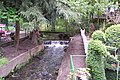
Itter at Obenitter

Obenitterstrasse 57 (17th century)

Ittertal amusement park

Historic water carousel


swell
- ↑ Hans Brangs: Explanations and explanations of the corridor, place, yard and street names in the city of Solingen , Solingen 1936
- ^ City of Solingen: Street and place names in our city of Solingen , self-published, Solingen 1972
- ^ A b Heinrich Dittmaier : Settlement names and settlement history of the Bergisches Land . In: Journal of the Bergisches Geschichtsverein . tape 74 , parallel edition as a publication by the Institute for Historical Regional Studies of the Rhineland at the University of Bonn. Schmidt, Neustadt ad Aisch 1956.
- ^ A b Marina Alice Mutz: Ittertaler Volksgarten. In: Time Track Search. Retrieved December 15, 2016 .
- ^ Topographic map of the Düsseldorf administrative district . Designed and executed according to the cadastral recordings and the same underlying and other trigonometric work by the Royal Government Secretary W. Werner. Edited by the royal government secretary FW Grube. 4th rev. Edition / published by A. Bagel in Wesel, 1859 / Ddf., Dec. 17, 1870. J. Emmerich, Landbaumeister. - Corrected after the ministerial amendments. Ddf. d. Sept. 1, 1871. Bruns.
- ↑ a b c Johann Georg von Viebahn : Statistics and Topography of the Düsseldorf Government District , 1836
- ↑ Friedrich von Restorff : Topographical-statistical description of the Royal Prussian Rhine Province , Nicolai, Berlin and Stettin 1830
- ↑ Royal Statistical Bureau Prussia (ed.): The communities and manor districts of the Prussian state and their population . The Rhine Province, No. XI . Berlin 1874.
- ↑ Königliches Statistisches Bureau (Prussia) (Ed.): Community encyclopedia for the Rhineland Province, based on the materials of the census of December 1, 1885 and other official sources, (Community encyclopedia for the Kingdom of Prussia, Volume XII), Berlin 1888.
- ↑ Königliches Statistisches Bureau (Prussia) (Ed.): Community encyclopedia for the Rhineland Province, based on the materials of the census of December 1, 1895 and other official sources, (Community encyclopedia for the Kingdom of Prussia, Volume XII), Berlin 1897.
- ↑ Royal Statistical Bureau (Prussia) (Ed.): Community encyclopedia for the Rhineland Province, based on the materials of the census of December 1, 1905 and other official sources, (Community encyclopedia for the Kingdom of Prussia, Volume XII), Berlin 1909
- ↑ Solingen Monument List ( Memento of the original from December 18, 2015 in the Internet Archive ) Info: The archive link was inserted automatically and has not yet been checked. Please check the original and archive link according to the instructions and then remove this notice. . City of Solingen, July 1, 2015, accessed on September 15, 2016 (PDF, size: 129 kB).
Adamsfeld | Altenhof | Backesheide | Bauskotten | Bausmühle | Buckert | Büschberg | Buxhaus | Dent | Demmeltrath | Thing house | Dorpskotten | Duldgenstal | Ehrener mill | Own | Own mountain | Own field | Egg passport | Eschbach | Fields yard | Fürkeltrath | Drove | Frisian house | Goodness | Rooster House | Hedges | Heidufer | Henshaus | Hostel | Height | Wood | Hedgehog forest | Itterberg | Itterbruch | Kleinenberg | Knynsbusch | Pukes | Puked sticks | Scratch pads | Frills | Way of the Cross | Lauterjungskotten | Lehn | Lindersberg | Hole | Punch hammer | Lochskotten | Corn oak | Mittelgönrath | Middle knight | Mummenscheid | New Egg Pass | Neuenkotten | Obengönrath | Top nitter | Obenmangenberg | Obenscheidt | Rolsberg | Turnpike | Scheider mill | Scheiderfeld | Scouring | Schneppert | Sonnenkamp | Sunshine | Worry House | Stübben | Shrub | Deep Thick | Untengönrath | Bottom sitter | Untermangenberg | Untenscheidt | Vogelsang | Forest | Waldheim | Westersburg | Wiedenhof | Wiedenkamp | Reflection | Wittkulle | Target cabins