
Fields yard
|
Fields yard
City of Solingen
Coordinates: 51 ° 11 ′ 19 ″ N , 7 ° 2 ′ 35 ″ E
|
||
|---|---|---|
| Height : | about 200 m | |
| Postal code : | 42719 | |
| Area code : | 0212 | |
Location of Felder Hof in Solingen |
||
 Fields yard
|
||

Felder Hof is a court in the Bergisch city of Solingen .
geography
Felder Hof is located in the Wald district of Solingen , on Wittkuller Straße north of the Walder town center. The place is located on a ridge above the Ittertal in the south of Obenitter . To the east of the Hof field lies Schneppert , and to the south-east lies the Sorgehaus estate . In the south lie the Grossmann factory area and the Adamsfeld estate . To the west is the Solingen-Wald industrial park and the Itterberg location .
etymology
Originally called just a field, the Hofschaft owes its name to the name given to an area used for agriculture . The addition Hof chosen in 1935 only serves to distinguish it from the other farms with the name field .
history
The farm Feld ( super campum ) near Wald is already mentioned in the collection register of the Gerresheim Monastery as an interest-bearing farm ; the register was created under Abbess Guda (1212/1232). It is possible that Feld's roots go back to the beginning of the 13th century. The Feldschaft can be safely traced back to the 16th century. In the year 1715 in the map Topographia Ducatus Montani , Blatt Amt Solingen , by Erich Philipp Ploennies the living space with a yard is recorded and named as a field . The court belonged to the Itter Honschaft within the Solingen office. The topographical survey of the Rhineland from 1824 records the place as on d. Feld and the Prussian first recording from 1844 as a field . The courtyard is also shown as a field on the topographic map of the Düsseldorf administrative district from 1871 .
After the Mairien and later mayor's offices were founded at the beginning of the 19th century, the farm belonged to the forest mayor's office . In 1815/16 80 people lived in Feld , in 1830 90 people . In 1832 the place was part of the first village honors within the forest mayor, there it was in the corridor I. ( Wittkull ). The place, which was categorized as a court town according to the statistics and topography of the Düsseldorf government district , had 17 houses, a factory or mill and nine agricultural buildings at that time. At that time, 70 residents lived in the place, eight of them Catholic and 62 Protestant denominations. The municipality and estate district statistics of the Rhine Province list the place in 1871 with 24 houses and 130 inhabitants. In the municipality lexicon for the Rhineland province from 1888, 30 houses with 201 inhabitants are given for field. In 1895 the district had 17 houses with 122 inhabitants, in 1905 22 houses and 138 inhabitants are given.
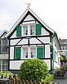
With the town union of Groß-Solingen in 1929 the Hofschaft Feld became part of Solingen. After the city union there were various other farms named Feld in Solingen, including I. , II. , III. and IV. field as well as several field roads. To make it easier to differentiate, the Walder Feld was given the name Felder Hof on April 26, 1935 . In the course of the reorganization program for the courts at the end of the 1970s, some buildings at the Felder Hof were renumbered as Wittkuller Straße, but the street name Felder Hof was retained for smaller access roads. Although many half-timbered houses at the Felder Hof were completely neglected and demolished in the 1960s and 1970s, some are still standing today. The buildings Felder Hof 14, 19, 39 and 44 as well as Wittkuller Straße 125a have been under monument protection since 1984/1985 .
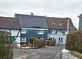
Half-timbered houses in fields courtyard
Half-timbered house Felder Hof 14

Half-timbered house Felder Hof 19


Web links
swell
- ↑ Hans Brangs: Explanations and explanations of the corridor, place, yard and street names in the city of Solingen , Solingen 1936
- ↑ a b City of Solingen: Street and place names in our city of Solingen , self-published, Solingen 1972
- ↑ a b Marina Alice Mutz: In the field. In: Time Track Search. Retrieved September 7, 2016 .
- ^ Topographic map of the Düsseldorf administrative district . Designed and executed according to the cadastral recordings and the same underlying and other trigonometric work by the Royal Government Secretary W. Werner. Edited by the royal government secretary FW Grube. 4th rev. Edition / published by A. Bagel in Wesel, 1859 / Ddf., Dec. 17, 1870. J. Emmerich, Landbaumeister. - Corrected after the ministerial amendments. Ddf. d. Sept. 1, 1871. Bruns.
- ↑ a b c Johann Georg von Viebahn : Statistics and Topography of the Düsseldorf Government District , 1836
- ↑ Friedrich von Restorff : Topographical-statistical description of the Royal Prussian Rhine Province , Nicolai, Berlin and Stettin 1830
- ↑ Royal Statistical Bureau Prussia (ed.): The communities and manor districts of the Prussian state and their population . The Rhine Province, No. XI . Berlin 1874.
- ↑ Königliches Statistisches Bureau (Prussia) (Ed.): Community encyclopedia for the Rhineland Province, based on the materials of the census of December 1, 1885 and other official sources, (Community encyclopedia for the Kingdom of Prussia, Volume XII), Berlin 1888.
- ↑ Königliches Statistisches Bureau (Prussia) (Ed.): Community encyclopedia for the Rhineland Province, based on the materials of the census of December 1, 1895 and other official sources, (Community encyclopedia for the Kingdom of Prussia, Volume XII), Berlin 1897.
- ↑ Königliches Statistisches Bureau (Prussia) (Ed.): Community encyclopedia for the Rhineland Province, based on the materials of the census of December 1, 1905 and other official sources, (Community encyclopedia for the Kingdom of Prussia, Volume XII), Berlin 1909.
- ↑ Hans Brangs: Explanations and explanations of the corridor, place, yard and street names in the city of Solingen , Solingen 1936
- ↑ Solingen Monument List . City of Solingen, July 1, 2015, accessed on March 13, 2017 (PDF, size: 129 kB).
Adamsfeld | Altenhof | Backesheide | Bauskotten | Bausmühle | Buckert | Büschberg | Buxhaus | Dent | Demmeltrath | Thing house | Dorpskotten | Duldgenstal | Ehrener mill | Own | Own mountain | Own field | Egg passport | Eschbach | Fields yard | Fürkeltrath | Drove | Frisian house | Goodness | Rooster House | Hedges | Heidufer | Henshaus | Hostel | Height | Wood | Hedgehog forest | Itterberg | Itterbruch | Kleinenberg | Knynsbusch | Pukes | Puked sticks | Scratch pads | Frills | Way of the Cross | Lauterjungskotten | Lehn | Lindersberg | Hole | Punch hammer | Lochskotten | Corn oak | Mittelgönrath | Middle knight | Mummenscheid | New Egg Pass | Neuenkotten | Obengönrath | Top nitter | Obenmangenberg | Obenscheidt | Rolsberg | Turnpike | Scheider mill | Scheiderfeld | Scouring | Schneppert | Sonnenkamp | Sunshine | Worry House | Stübben | Shrub | Deep Thick | Untengönrath | Bottom sitter | Untermangenberg | Untenscheidt | Vogelsang | Forest | Waldheim | Westersburg | Wiedenhof | Wiedenkamp | Reflection | Wittkulle | Target cabins