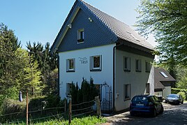
Itterbruch
|
Itterbruch
City of Solingen
Coordinates: 51 ° 12 ′ 2 " N , 7 ° 3 ′ 5" E
|
||
|---|---|---|
| Height : | about 170 m | |
| Postal code : | 42719 | |
| Area code : | 0212 | |
|
Location of Itterbruch in Solingen |
||
|
Itterbruch
|
||
Itterbruch is a locality in the mountainous city of Solingen .
geography
Itterbruch is located at the lower end of Eipaßstrasse in the eastern part of the Wald district on the border with Gräfrath . It is located north of Eschbach at around 170 meters above sea level and on the slopes of the valley that slope towards the Itter . The Bausmühle and Bauskotten are located near Eschbach in the south, and the Ehrener Mühle estate is located south on the banks of the Nümmener Bach . To the north are Fürkeltrath , Buxhaus and Eipaß . To the west is the Hofschaft Holz .
etymology
The place name Itterbruch is probably derived from the nearby Itter. The part of the name -bruch indicates a swampy terrain.
history
Itterbruch already existed in 1492, the place is mentioned for the first time in a document as ytterbroich in that year . In 1715 in the map Topographia Ducatus Montani , Blatt Amt Solingen , by Erich Philipp Ploennies , the place is recorded with a farm and named as Itterbruch . The court belonged to the Itter Honschaft within the Solingen office. The topographical survey of the Rhineland from 1824 lists the place as Itterbruch . The Prussian first recording from 1843 shows the place unlabeled , in the topographical map of the administrative district of Düsseldorf from 1871 the place is also recorded without a name.
After the Mairien and later mayor's offices were founded at the beginning of the 19th century, the farm belonged to the forest mayor's office . 1815/16 lived 39, in 1830, 46 people in a hamlet called Itter break . In 1832 the place was part of the first village honors within the mayor's office forest, there it was in the corridor II. ( Wood ). The place, which was categorized as a court town according to the statistics and topography of the Düsseldorf administrative district , had 13 residential houses and six agricultural buildings at that time. At that time 44 residents lived in the place, eight of them Catholic and 36 Protestant denominations. The municipality and estate district statistics of the Rhine Province list the place in 1871 with nine houses and 67 inhabitants. In the municipality lexicon for the Rhineland province of 1888, twelve houses with 85 inhabitants are given for Itterbruch. In 1895 the district had 13 houses with 96 inhabitants, in 1905 ten houses and 88 inhabitants are given.
With the town union of Groß-Solingen in 1929, Itterbruch became a district of Solingen. The buildings belonging to the location are now all numbered towards Eipaßstraße, the street name Itterbruch can no longer be found in the city map.
swell
- ↑ a b Hans Brangs: Explanations and explanations of the hall, place, yard and street names in the city of Solingen , Solingen 1936
- ^ Topographic map of the Düsseldorf administrative district . Designed and executed according to the cadastral recordings and the same underlying and other trigonometric work by the Royal Government Secretary W. Werner. Edited by the royal government secretary FW Grube. 4th rev. Edition / published by A. Bagel in Wesel, 1859 / Ddf., Dec. 17, 1870. J. Emmerich, Landbaumeister. - Corrected after the ministerial amendments. Ddf. d. Sept. 1, 1871. Bruns.
- ↑ a b c Johann Georg von Viebahn : Statistics and Topography of the Düsseldorf Government District , 1836
- ↑ Friedrich von Restorff : Topographical-statistical description of the Royal Prussian Rhine Province , Nicolai, Berlin and Stettin 1830
- ↑ Royal Statistical Bureau Prussia (ed.): The communities and manor districts of the Prussian state and their population . The Rhine Province, No. XI . Berlin 1874.
- ↑ Königliches Statistisches Bureau (Prussia) (Ed.): Community encyclopedia for the Rhineland Province, based on the materials of the census of December 1, 1885 and other official sources, (Community encyclopedia for the Kingdom of Prussia, Volume XII), Berlin 1888.
- ↑ Königliches Statistisches Bureau (Prussia) (Ed.): Community encyclopedia for the Rhineland Province, based on the materials of the census of December 1, 1895 and other official sources, (Community encyclopedia for the Kingdom of Prussia, Volume XII), Berlin 1897.
- ↑ Königliches Statistisches Bureau (Prussia) (Ed.): Community encyclopedia for the Rhineland Province, based on the materials of the census of December 1, 1905 and other official sources, (Community encyclopedia for the Kingdom of Prussia, Volume XII), Berlin 1909.

