
Eigen (Solingen)
|
Own
City of Solingen
Coordinates: 51 ° 10 ′ 59 " N , 7 ° 3 ′ 39" E
|
||
|---|---|---|
| Height : | about 205 m | |
| Postal code : | 42655 | |
| Area code : | 0212 | |
Location of Eigen in Solingen |
||
 Own
|
||

Own is a farm in the Solingen district of Wald .
geography
Eigen lies in the border area of the districts of Wald, Gräfrath and Mitte between the Lochbach in the south and the embankment of the corkscrew route in the north. To the west is the local area Eigener Berg , to the south-west, following the course of the Lochbach, is the Dältgenstal . Lehn is located on the southern slope of the Lochbach valley, to the east are Hecken , Herberg and Untenscheidt . Vogelsang is located north of the railway embankment .
etymology
The word own means own property, own good (= allod ) in contrast to fiefdom . This means that the owner of the farm was not bound by any obligations towards the owner (such as paying taxes).
history
The history of the Eigen estate can be traced back to the 15th century. Erich Philipp Ploennies recorded the farm in 1715 in the map Topographia Ducatus Montani , Blatt Amt Solingen, and named it oak . He belonged to the Scheid Honschaft within the Solingen office. The topographical survey of the Rhineland from 1824 lists the site as an own and the Prussian first survey of 1844 also as an own . In the topographical map of the Düsseldorf administrative district from 1871, the place is again listed as an own .
After the Mairien and later mayor's offices were founded at the beginning of the 19th century, Eigen was part of the Wald mayorry . In 1815/16 79, in 1830 90 people lived in the property . In 1832 the place was part of the Second Dorfhonschaft within the mayor's office forest, there it was in the corridor III. ( Scheid ). The place, which was categorized as a court town according to the statistics and topography of the administrative district of Düsseldorf , had 16 residential buildings and eleven agricultural buildings at that time. At that time, 83 residents lived in the place, including 21 Catholic and 62 Protestant denominations. The municipality and estate district statistics of the Rhine Province list the place in 1871 with 33 houses and 178 inhabitants. In the municipality lexicon for the Rhineland province of 1888, 27 houses with 165 inhabitants are given for Eigen. In 1895 the district had 39 houses with 253 inhabitants, in 1905 20 houses and 171 inhabitants are given.
In 1887 the Solingen – Wuppertal-Vohwinkel railway line was laid past the site . With the town union of Groß-Solingen in 1929, the court estate Eigen became a district of Solingen. The construction work on Frankfurter Damm as a bypass road between Mitte and Wald and past the Hofschaft began in 1934 as an emergency project to combat unemployment in Solingen, but was not completed for the time being. The road construction project was only taken up again in the post-war period, the Frankfurter Damm was completed in its current size and inaugurated on February 11, 1967.
Since 1984/1985 of the historical half-timbered houses in Eigen, the buildings Eigen 14 and 14a, 15, 20 and 20a, 22 and 24b have been under monument protection .
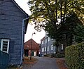
Half-timbered houses in their own

Half-timbered house in own


Web links
swell
- ↑ Hans Brangs: Explanations and explanations for the corridor, place, yard and street names in the city of Solingen . Solingen 1936
- ↑ a b City of Solingen: Street and place names in our city of Solingen , self-published, Solingen 1972
- ^ Topographic map of the Düsseldorf administrative district . Designed and executed according to the cadastral recordings and the same underlying and other trigonometric work by the Royal Government Secretary W. Werner. Edited by the royal government secretary FW Grube. 4th rev. Edition / published by A. Bagel in Wesel, 1859 / Ddf., Dec. 17, 1870. J. Emmerich, Landbaumeister. - Corrected after the ministerial amendments. Ddf. d. Sept. 1, 1871. Bruns.
- ↑ a b c Johann Georg von Viebahn : Statistics and Topography of the Düsseldorf Government District , 1836
- ↑ Friedrich von Restorff : Topographical-statistical description of the Royal Prussian Rhine Province , Nicolai, Berlin and Stettin 1830
- ↑ Royal Statistical Bureau Prussia (ed.): The communities and manor districts of the Prussian state and their population . The Rhine Province, No. XI . Berlin 1874.
- ↑ Königliches Statistisches Bureau (Prussia) (Ed.): Community encyclopedia for the Rhineland Province, based on the materials of the census of December 1, 1885 and other official sources, (Community encyclopedia for the Kingdom of Prussia, Volume XII), Berlin 1888.
- ↑ Königliches Statistisches Bureau (Prussia) (Ed.): Community encyclopedia for the Rhineland Province, based on the materials of the census of December 1, 1895 and other official sources, (Community encyclopedia for the Kingdom of Prussia, Volume XII), Berlin 1897.
- ↑ Königliches Statistisches Bureau (Prussia) (Ed.): Community encyclopedia for the Rhineland Province, based on the materials of the census of December 1, 1905 and other official sources, (Community encyclopedia for the Kingdom of Prussia, Volume XII), Berlin 1909.
- ^ Solinger Tageblatt from the series search for traces / street names
- ↑ Solingen Monument List ( Memento from December 18, 2015 in the Internet Archive ). City of Solingen, July 1, 2015, accessed on July 3, 2016 (PDF, size: 129 kB).
Adamsfeld | Altenhof | Backesheide | Bauskotten | Bausmühle | Buckert | Büschberg | Buxhaus | Dent | Demmeltrath | Thing house | Dorpskotten | Duldgenstal | Ehrener mill | Own | Own mountain | Own field | Egg passport | Eschbach | Fields yard | Fürkeltrath | Drove | Frisian house | Goodness | Rooster House | Hedges | Heidufer | Henshaus | Hostel | Height | Wood | Hedgehog forest | Itterberg | Itterbruch | Kleinenberg | Knynsbusch | Pukes | Puked sticks | Scratch pads | Frills | Way of the Cross | Lauterjungskotten | Lehn | Lindersberg | Hole | Punch hammer | Lochskotten | Corn oak | Mittelgönrath | Middle knight | Mummenscheid | New Egg Pass | Neuenkotten | Obengönrath | Top nitter | Obenmangenberg | Obenscheidt | Rolsberg | Turnpike | Scheider mill | Scheiderfeld | Scouring | Schneppert | Sonnenkamp | Sunshine | Worry House | Stübben | Shrub | Deep Thick | Untengönrath | Bottom sitter | Untermangenberg | Untenscheidt | Vogelsang | Forest | Waldheim | Westersburg | Wiedenhof | Wiedenkamp | Reflection | Wittkulle | Target cabins