
Honorable mill
|
Honorable mill
City of Solingen
Coordinates: 51 ° 11 ′ 52 ″ N , 7 ° 3 ′ 20 ″ E
|
||
|---|---|---|
| Height : | about 170 m | |
| Postal code : | 42653 | |
| Area code : | 0212 | |
Location of Ehrener Mühle in Solingen |
||
 Honorable mill
|
||

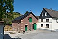
Ehrener Mühle is a courtyard on the northeastern edge of the Wald district in the Bergisch city of Solingen .
geography
The Ehrener Mühle estate is located west of Ehren in the valley floor of the Nümmener Bach at about 170 meters above sea level . Apple tree and the Fuhr are on a ridge south of the Hofschaft . Southwest is Buckert , west are Eschbach and the construction mill , north on an elevation above the Ittershagen the local situation Ittershagen fracture . To the northeast is Mühlenbusch .
etymology
Attempts to interpret the name of the court have so far been unsuccessful. According to Hans Brangs, the name could have come from the fact that the estate could possibly have been created in honor of Saint Catherine . However, all attempts to link the court name with membership of the Gräfrath monastery fail because the name has existed as a field name since the 14th century.
According to Dittmaier , it is therefore more of an old phonetic form of the tree name maple : Urgerm. * ahira- , dan. aer , in Rhenish dialects also ire , eren , berg. hear .
history
The court was first mentioned in a document in 1374 and was a watermill on the Nümmener Bach until the 20th century . Up until the 19th century, this courtyard was called Zur Große Ehren , while today's Ehrenberg was called Zur kleine Ehren . The latter appears for the first time in the map Topographia Ducatus Montani , Blatt Amt Solingen , by Erich Philipp Ploennies from 1715 and is recorded there as Kl. Irren . It remains unclear whether the two farms used to belong together and whether Ehren was also owned by the Gräfrath monastery.
The Ehrener Mühle belonged to the Itter Honschaft within the Solingen office . The topographical survey of the Rhineland from 1824 shows the Ehrener Mühle with the mill symbol and honors as Zum Ehren . The Prussian first recording from 1844 record the living spaces as Ehrener M. , also with a mill symbol, and honors .
After the Mairien and later mayor's offices were founded at the beginning of the 19th century, the Ehrener Mühle belonged to the Wald mayor's office . In 1815/16 two residents lived in the village. In 1830/1832 Ehrener Mühle belonged to the first village honors within the mayor's office, where it was located in corridor II. ( Wood ). The place, which was categorized as a fruit mill according to the statistics and topography of the administrative district of Düsseldorf and called an Ehrnermühle , had two houses, a mill and two agricultural buildings at that time. At that time 37 residents lived in the place, six of them Catholic and 31 Protestant denominations. The municipality and estate district statistics of the Rhine Province list the place in 1871 with two houses and 18 inhabitants. In the municipality lexicon for the Rhineland province in 1885, three houses with 15 inhabitants are given. In 1895 the district had three houses with 26 inhabitants, for 1905 three houses and 17 inhabitants were given.
With the town union of Groß-Solingen in 1929, the Ehrener Mühle residential area became a district of Solingen. The mill was probably converted into a residential building in the late 1950s, the upper ditch and pond were filled in, and the water wheel and gear were removed. At the beginning of the 2000s, a rainwater retention basin was built by the Bergisch-Rheinischer Wasserverband south of Ehren, at the location of the old Ehrener Kotten in the valley of the Nümmener Bach .

Ehrener Mühle residence

Ehrener Mühle riding stables
Ehrener Mühle riding stables

Rainwater retention basin


Web links
- Marina Alice Mutz: Ehrener Mühle , on zeitspurensuche.de
swell
- ↑ Hans Brangs: Explanations and explanations of the corridor, place, yard and street names in the city of Solingen , Solingen 1936
- ↑ a b Marina Alice Mutz: Honors. In: Time Track Search. Retrieved May 14, 2016 .
- ^ Heinrich Dittmaier : settlement names and settlement history of the Bergisches Land. Schmidt, Neustadt ad Aisch 1956 (magazine of the Bergisches Geschichtsverein, 74 - parallel edition as a publication by the Institute for Historical Regional Studies of the Rhineland at the University of Bonn), p. 187
- ↑ a b Johann Georg von Viebahn : Statistics and Topography of the Administrative District of Düsseldorf , 1836
- ^ The communities and manor districts of the Rhine Province and their population. Edited and compiled by the Royal Statistical Bureau from the original materials of the general census of December 1, 1871. In: Königliches Statistisches Bureau (Hrsg.): The communities and manor districts of the Prussian state and their population. tape XI , 1874, ZDB -ID 1467523-7 ( digitized ).
- ^ Community encyclopedia for the province of Rhineland. Based on materials from the census of December 1, 1885 and other official sources, edited by the Royal Statistical Bureau. In: Royal Statistical Bureau (Hrsg.): Community encyclopedia for the Kingdom of Prussia. tape XII , 1888, ZDB -ID 1046036-6 ( digitized version ).
- ^ Community encyclopedia for the province of Rhineland. Based on materials from the census of December 1, 1895 and other official sources, edited by the Royal Statistical Bureau. In: Royal Statistical Bureau (Hrsg.): Community encyclopedia for the Kingdom of Prussia. tape XII , 1897, ZDB -ID 1046036-6 .
- ^ Community encyclopedia for the Rhine Province. Based on the materials from the census of December 1, 1905 and other official sources, edited by the Royal Prussian State Statistical Office. In: Königliches Prussisches Statistisches Landesamt (Hrsg.): Community encyclopedia for the Kingdom of Prussia. Booklet XII, 1909, ZDB -ID 1046036-6 .
- ↑ Marina Alice Mutz: Ehrener Kotten. In: Time Track Search. Retrieved May 14, 2016 .
Adamsfeld | Altenhof | Backesheide | Bauskotten | Bausmühle | Buckert | Büschberg | Buxhaus | Dent | Demmeltrath | Thing house | Dorpskotten | Duldgenstal | Ehrener mill | Own | Own mountain | Own field | Egg passport | Eschbach | Fields yard | Fürkeltrath | Drove | Frisian house | Goodness | Rooster House | Hedges | Heidufer | Henshaus | Hostel | Height | Wood | Hedgehog forest | Itterberg | Itterbruch | Kleinenberg | Knynsbusch | Pukes | Puked sticks | Scratch pads | Frills | Way of the Cross | Lauterjungskotten | Lehn | Lindersberg | Hole | Punch hammer | Lochskotten | Corn oak | Mittelgönrath | Middle knight | Mummenscheid | New Egg Pass | Neuenkotten | Obengönrath | Top nitter | Obenmangenberg | Obenscheidt | Rolsberg | Turnpike | Scheider mill | Scheiderfeld | Scouring | Schneppert | Sonnenkamp | Sunshine | Worry House | Stübben | Shrub | Deep Thick | Untengönrath | Bottom sitter | Untermangenberg | Untenscheidt | Vogelsang | Forest | Waldheim | Westersburg | Wiedenhof | Wiedenkamp | Reflection | Wittkulle | Target cabins