
Castle on the Wupper
|
Castle on the Wupper
City of Solingen
|
|
|---|---|
 |
|
| Height : | 98 (–200) m above sea level NHN |
| Residents : | 1500 (2014) |
| Incorporation : | 1st January 1975 |
| Postal code : | 42659 |
| Area code : | 0212 |
 Location of Burg an der Wupper in Solingen
|
|

Burg an der Wupper (abbreviated to Burg ) is a district of the Bergisch city of Solingen and, together with the Höhscheid district, forms the Burg / Höhscheid district . Up until the regional reform of 1975 , Burg was one of the smallest towns in North Rhine-Westphalia with around 2000 inhabitants .
The district consists of the two districts of Upper and Lower Castle. In Oberburg there is the Bergisch ducal residence Schloss Burg , built in the 12th century , which was largely destroyed in the Thirty Years' War and rebuilt between 1890 and 1914 in a historicizing manner. Since then it has been the largest restored castle complex in North Rhine-Westphalia.
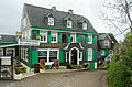
Unterburg is best known for its closed development with centuries-old half-timbered houses . In addition to the trolleybus turntable, there is also the Burg cable car , which is mainly used by tourists , and connects the two districts.
geography
The Burg district is located in the northwest of the Bergische plateau , at the transition from the Solingen ridge to the Remscheid Bergland , which is formed by the western Wupperengal . The district of Unterburg is located at the confluence of the Eschbach in the Wupper at 98 to 105 meters above sea level , Oberburg with the castle is on a ridge about 100 meters above the Wupper at around 180 to 200 meters above sea level.
Burg is located about six kilometers as the crow flies southeast of downtown Solingen, six kilometers southwest of Remscheid and five kilometers west of Wermelskirchen in the Bergisches Land.
history
Early history

The Bergisches Land remained uninhabited for a long time due to its dense forests and its sometimes demanding topography ; the Romans only penetrated as far as Cologne at that time. It was not until the 7th century that people spread to the areas on the other side of the Rhine that were more difficult to cultivate . With their settlement, the first monasteries were founded and the area was gradually Christianized .
At the turn of the first millennium, the von Berg gentlemen achieved some prosperity in the region. The later first Count von Berg was Adolf , who is mentioned in 1056 as Vogt of the Gerresheim Monastery . His son, Adolf II. Von Berg , who was born around the year 1100, ruled from 1115 to 1160. Under Count Adolf II, the old ancestral seat of the Counts of Berg, Berge Castle near Altenberg in the Oberbergisches Land , was given up in 1133 and left to the Cistercians . The ruling family moved to the newly built Novo Monto further north, today's Burg Castle , on a hill above a narrow valley of the Wupper . The position of the castle in the densely wooded area, high on a rock, was chosen for strategic reasons.
Origins of settlement

The construction of the castle is also the starting point for the Burg settlement, which is also named after it. The origins of the settlement of the place are estimated at the end of the 12th century. In 1170, Count Engelbert I founded a commander of the Johanniter inside the castle. The first church was built before 1200. Between 1218 and 1225, under Count Engelbert II , the castle was expanded and the outer castle wall was built . As early as the 13th century there was a ducal grain mill outside the castle.
Settlement on Steinweg can be traced back to 1350, so that the castle walls could no longer represent the boundary of the place early on. As freedom in the Duchy of Berg , Burg already formed its own administration, the place Burg als Freiheit was first mentioned in a document in 1363. The Counts of Berg moved their seat of government to Düsseldorf in the 14th century . Despite the relocation, the ruling family continued to use the castle frequently in the 15th century and less often in the 16th century.
15th to 18th century
As a result of the relocation, the entourage of the Counts of Berg gave up their castle fiefs at the end of the 14th century and in the 15th century. At the end of the 15th century, the area up to the outer castle wall and parts of today's upper castle on Wermelskirchener Strasse were sparsely populated. In addition, today's Schlossbergstrasse was already loosely built on both sides at that time. The settlement of the Eschbach estuary and the Wupper crossing in what is now the lower castle also fell during this time. The settlement then expanded continuously up the Eschbach.
Trades practiced in Burg have been demonstrable since the 2nd half of the 15th century , including the cloth making trade as the most important over the centuries. The blanket makers in particular made up a large number. The fishery on the Wupper and Eschbach was also investigated.
In 1530 and 1535 the castle and the winery were pawned, in the 16th and 17th centuries the castle served as the seat of the bailiff and waiter. During the Thirty Years War the castle was subjected to changing occupations until it and some outbuildings were finally destroyed in 1648. However, it remained the seat of the Burg waiter and judge until 1807. The development of today's Müngstener Straße is documented for the second half of the 16th century, the water power of the Eschbach was used from the middle of the 17th century. Commercial use was carried out by Schleifkotten and hammer works on the Eschbach from the mouth to the Kellershammer and on the Wupperufer downstream to the present day sewage treatment plant.

The burgers made it a point to practice their religion of choice in the Oberburg parish church of St. Martinus . In 1553 almost the entire congregation converted to the Lutheran faith. Later, Lutherans and Catholics took turns using the house of God. For many years there was a dispute over ownership of the church. In the 17th century, a Counter-Reformation split the Lutherans into two camps, which fueled the dispute. Due to the destruction of St. Martinus in the Thirty Years War , the Lutherans initially found shelter in what is now Müngstener Strasse, before they built their first church there between 1732 and 1735 from the remains of the destroyed castle . This process led to the confessional division of the place into the Lutheran lower and the Catholic upper castle. The Catholics initially prevented the construction of a tower with bells, and it was only around 50 years later that the church tower could be built with the permission of the elector. In 1653, 30 houses were destroyed in a town fire in Unterburg. In 1740 the entire place consisted of 200 old buildings. In the first half of the 18th century, the castle was repaired. The local economy stagnated in the 18th and early 19th centuries.
19th century
In 1808 another eight houses in Unterburg were destroyed by a city fire. The expansion of the streets in Burg and the first post office took place in the first half of the 19th century, the so-called Chaussee Burg – Solingen, for example, today's Burger Landstrasse, was built between 1824 and 1825. House numbering was introduced in 1836.
On April 24, 1806, after occupying the Rhineland , the French founded the Grand Duchy of Berg , to which Burg also belonged. In addition to the modernization of the administration, this brought the division of the areas into municipalities ( called Mairies from 1808 ). On October 25, 1808, Burg applied to be allowed to form its own mairie and thus not be assigned to Wermelskirchen . Despite the actually required minimum number of 1,500 inhabitants - Burg had only 1,245 inhabitants - the application was granted on December 19, 1808, thanks to a positive opinion from the Solingen administrative officer Krey. Burg now belonged to the canton of Wermelskirchen in the Elberfeld arrondissement as a separate mairie . After France withdrew in 1813, Prussia took over the administration of the Grand Duchy. From the Mairie Castle in 1816 was mayor castle , which the district Solingen has been assigned. On October 30, 1819, Burg was assigned to the Lennep district, which emerged from the canton of Wermelskirchen .
In the 19th century the castle housed the school, a blanket factory and a wool spinning mill at the same time . In 1849 parts of the roof of the castle were used to build the regional court in Elberfeld . On August 18, 1856, the mayor's Castle received after the Rhenish order the city charter and was in this context in Burg on the Wupper renamed. In 1864, the town of Burg included the lower and upper castle with 1,680 inhabitants as well as the following places :
|
|

1887 founded the Association for the Preservation of the ruined castle to castle on the Wupper , which since 1897 on the Wupper Castle Building Association Burg is, with the objective to build the castle ruins again. In 1889, the Burger Rathaus was built on Solinger Strasse, an area that until then had only been used as garden and pasture land. In 1890 the first narrow-gauge railway went into operation in the Eschbachtal , which was electrified after a few years. This is the route Burg – Burgtal – Kellershammer – Talsperre.
20th century until today

Between 1887 and 1914, the historicizing reconstruction of Burg Castle took place according to plans by the architect Gerhard August Fischer . 1920 burned the castle, the new reconstruction took place between 1922 and 1927. After Prussia among Lennep had transferred the castle in 1897, it went after its dissolution to 48 percent in the possession of was established in 1929 in its place Rhine Wupper circle over , to which the city of Burg now belonged. The remaining 52 percent was split between the city of Remscheid with 31 percent and the city of Wuppertal with 21 percent. In 1975 the city of Solingen took over the shares of the dissolved Rhein-Wupper-Kreis.
In 1908 the first tram ran between the castle and the Krahenhöhe . The Burg – Kellershammer – Tyrol – Ehringhausen tram ran from 1925.
During the Second World War , 18 buildings in Burg were completely destroyed and 34 badly damaged. In the post-war period , Burg an der Wupper became an important tourist destination; the castle complex itself, as well as the numerous cafes, restaurants and hotels in the half-timbered and slate backdrop of the village, attracted many visitors. This boom peaked in the 1950s and 1960s.
After 1945, buildings were built on both sides of Hasencleverstrasse up to the sewage treatment plant in Unterburg and in the area around the youth hostel in Oberburg. In 1968 there were 340 buildings in Burg, 170 of which were from before 1900, 36 were built between 1901 and 1948 and 134 afterwards. In 1970 the city of Burg consisted of the following residential areas:
|
|
The city of Burg was one of the smallest cities in the country with a total of 2,055 inhabitants. The state government in North Rhine-Westphalia 's objective since the mid-1960s, in the form of a large-scale territorial reform unite the cities and towns to larger and more powerful municipalities. The sub-area Mönchengladbach-Düsseldorf-Wuppertal formed the conclusion of the reforms of the 2nd reorganization program within the North Rhine-Westphalian regional reform in 1974 . The Rhein-Wupper district was up for grabs: the neighboring cities of Leverkusen , Düsseldorf , Remscheid and Solingen made territorial claims at the expense of the district. Burg was also unable to maintain its independence under these circumstances. On January 1, 1975, the city of Burg was incorporated into Solingen according to the so-called Düsseldorf law together with Höhrath, which was formerly part of Wermelskirchen, and Strohn . As a result of the incorporation, the following streets in Burg were renamed due to the duplication: Remscheider Strasse in Westhausener Strasse, Westhausener Strasse in Lehmkuhle, Mühlenstrasse in Mühlendamm, Nordstrasse in Waldstrasse, Ritterstrasse in Talsperrenstrasse.
After ten years of planning and twelve months of construction, the new Burger Wupperbrücke was inaugurated on August 11, 1989.
The Eschbach repeatedly overflows its banks in the Unterburg area. In the course of a flood protection renovation, the dam walls are currently being enlarged.
coat of arms
|
|
Blazon : "Split shield, above in silver growing, blue-crowned red lion facing to the right, holding a sword in its right paw, below in gold a six-spoke black wheel (model: seal of freedom)." |
Economy and tourism
Due to the unfavorable nature of the soil, the Burger economy was dominated by the textile industry from the start , agriculture always played a subordinate role. The presumably oldest trade, the drapery , was first mentioned in 1490, when the Freiheit Burg received the duty-free privilege , but it very likely had already existed some time before. The textile industry was already export-oriented in the 15th century and had its heyday in the 16th century. The goods were mainly sold in the Burger area, for example in Wipperfürth . But the trade did not succeed in asserting itself against the competition, although the draperies of the Freiheit Burg were under ducal privilege .
As a result, the economy in the 17th century therefore undertook a change towards the blanket making trade ; in 1706 the drapery privileges were transferred to the blanket makers. The raw materials for the production came mainly from Hessen , Braunschweig and Westphalia ( wool ), Brabant and Holland ( oils ) and Linz ( washing earth ). The finished blankets were primarily sold in Brabant, but were also exported to Holland, France and Jülich . But due to the disregard for the Burger duty-free, some blanket manufacturers from Burg migrated to Brabant or Jülich in the first half of the 18th century, where the first blanket factories were established a little later. In addition, there was the continental barrier imposed at the beginning of the 19th century , which forbade exports to Holland or France. The peddling trade gained more and more importance until the Prussian peddling legislation that came into force in 1824 put an end to this hustle and bustle. This led to the impoverishment of many blanket makers, and the abolition of the regulation in 1869 did not change anything, since the outdated production was hardly able to cope with the competition in the textile industry. Very few companies made the transition to industrial production , so that by the end of the 19th century the textile trade hardly played a role in Burg.
In addition to cloth and blanket makers, the metalworking industry also gained a foothold in Burg in the 17th century. In the 17th and 18th centuries, for example, a gunsmith's shop was of national importance in the town; known as so-called burger runs , the quality of the products at this establishment made a name for itself. The company went into decline at the end of the 18th century. But some large-scale operations also developed from the grinding docks and hammer mills built at Eschbach and Wupper. For example the old Kellershammer, from which a scythe factory emerged, later agricultural machine knives were produced in the factory by the Solingen company Rasspe . In the Burgtal a factory was built in 1843, which was first used as an iron foundry , then as a machine factory and finally as a ball factory. These large companies largely compensated for the loss of jobs in the textile industry.
Since the reconstruction of the castle, tourism has also played an important role, as the tourists who came to the castle were and still are earning money with restaurants and hotels. Furthermore, the pretzels produced in Burg were sold in the peddling trade until the 20th century. The large industrial companies in the Eschbachtal mostly found their decline in the late 20th century. Parts of the factory in the Burgtal have been operated as the Alte Schlossfabrik event hall since 2013 . In the more recent past of the place, the erotic discotheque Beverly has provided notable tourism, from which the local innkeepers and hoteliers in particular benefited. The Beverly was set on fire by an arsonist in the early morning of November 9, 2014 and burned to the ground during the day.
Transport and infrastructure


traffic
For a long time, Burg was connected to neighboring cities by tram lines that are now closed from Solingen along today's state road 407 and from Remscheid along the Eschbach . But in the 1950s, the Solingen trolleybus replaced the tram. Today there are bus connections from Burg to the neighboring cities of Remscheid, Wermelskirchen and Burscheid , as well as to Solingen and Höhrath.
The Schloss Burg / Wermelskirchen exit on Autobahn 1 is just a few kilometers east of Burg.
Cable car
There is also an aerial cableway, the Burg cable car, for overcoming the height difference between the lower castle and the castle . Since 1952, it has been available to pedestrians alongside a serpentine path . It was designed by Ernst Wilfer and transports around 200,000 passengers a year. The valley station is located on Hasencleverstraße near the town hall, from there the cable car first crosses the Wupper before overcoming the 90m difference in altitude over a steep meadow. The mountain station is located above the Steinweg, with the exit to Schlossplatz. The entire driving distance is about 250 meters.
Trolleybus turntable
Since its establishment, the Unterburg turntable has been a curiosity of the Solingen trolleybus operation . When the change from the tram to the trolleybus was implemented at the end of the 1950s, a space problem arose in Unterburg due to the Wupper on one side and a steep slope on the other. The last tram line 3 from Solingen had to end in front of the Burger Bridge, as it was destroyed in World War II. A coupling terminal was used there to save space, that is, the railcar bypassed the wagons on a parallel track and was attached in the other direction to continue the journey in the opposite direction.
This is not possible with buses, so in 1959 an electrically operated turntable was set up as a turning option for trolleybuses . On December 2, 1959, the first trolleybus turned as scheduled on the turntable. Their use ended on November 15, 2009 after the trolleybus line 683 had been extended to the Burger Bahnhof on the other side of the Wupper. Since then, the turntable has been used exclusively for museum trips by the Solingen trolleybus museum .
Infrastructure
A youth hostel is located in Oberburg not far from the castle .
There are numerous designated hiking trails around the castle, including a forest damage path. The paths are partly unpaved and steep, which is due to the topography and the height differences between the two districts.
Culture and sights
_01_ies.jpg)
Buildings
Castle
Burg Castle is the castle complex from the High Middle Ages that dominates the Oberburg district and was completely historicized between 1887 and 1914 . Today the castle is the largest restored complex of its kind in North Rhine-Westphalia and consists of numerous individual buildings and walls. The Schlossbauverein still takes care of its preservation today . Schloss Burg houses the Bergisches Museum , which presents the history of the Counts of Berg in the castle's premises. The memorial of the German East and the Expulsion is housed in the battery tower of the castle .
Another popular way to get married is directly at the castle, where the Solingen registry office is housed in the bower .
Residential buildings

The old core of Unterburg on Eschbachstrasse, Müngstenerstrasse, Schloßbergstrasse and the street Mühlendamm as well as parts of Oberburg (mainly Wermelskirchener Strasse, Steinweg and Schlossplatz) consist of half-timbered and slate houses of the Bergisch style . For this building tradition, the green shutters , called in Bergisch Schlagladen , black studs and white clay frames , as well as gray-black slate facades and / or rubble stone bases are common. The oldest half-timbered houses were built in the 17th century, some after the last great city fire in 1653. Since 2013, Unterburg has been protected from major structural changes by a memorial area statute ; the area around the castle in Oberburg has been another memorial area since previous years, see also the list of architectural monuments in Solingen . In total there are around 75 monuments in Upper and Lower Castle.
The building of the former Kameralmühle is on the banks of the Eschbach, at the beginning of today's Mühlendamm. The first half-timbered building burned down in 1633 but was rebuilt. In 1756 the condition of the building was so bad that the then tenant Johannes Fischer had it rebuilt in brick . Mill operations were stopped in 1871 and a blanket factory was set up in the building. A grinding shop for Solingen blades later moved there, and today the building is used as a residential building. It has been a listed building since 1999.

former camera mill

Half-timbered house complex on Solinger Strasse

Slate house on Hasencleverstrasse
Slate houses on Schlossplatz

Half-timbered house on Eschbachstrasse

Partly slated half-timbered house on Müngstener Strasse


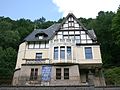
In and around Burg there are also three representative manufacturer's villas from the period between 1890 and 1914. Probably the most prominent is the Villa Breckerfeld on Hasencleverstrasse, whose builder in 1911 was the woolen blanket manufacturer Wilhelm Breckerfeld. It presents itself with numerous extensions, the high roof, the multiple barred windows, the slated upper floor with ornamental framework in the gables and Bergisch-green shutters as a picturesque example of the Neuberg style and has been a listed building since 1984. It was probably owned by the family or file company Georg Niebch & Sons after the First World War . The founder of this same company, Georg Niebch senior, had a factory owner's villa built at the lower end of Hasencleverstrasse in 1905. It is a two-and-a-half-storey, steeply proportioned, soberly plastered building with an ornamental framework in the gable fields.
Far outside Burg, following the course of Eschbachstrasse in the direction of Remscheid , is the Villa Steffens, built in 1904. The building, erected in a secluded location on the steep slope of the Eschbach Valley, sits enthroned above two retaining walls opposite the so-called new factory. It was originally a rolling mill for steel saw plates , which was founded in 1839 by the Remscheid businessman Daniel Hasenclever. After the factory was sold by Hasenclever's heirs, it came into the possession of the manufacturer Ernst Albert Steffens, who had machine knives produced there. The house consists of a high basement , a main floor and an attic. Stylistically it combines elements of the old German town houses and the first signs of a departure from the picturesque design principles of villa construction in the late 19th century.

Villa Breckerfeld

Villa Niebch
Villa Steffens


Sacred building
_01_ies.jpg)
There are two churches in Burg. The Catholic parish church of St. Martinus is located on Schlossplatz in Oberburg. It is the former church of the Johanniter - Kommende and was probably built before 1200. When Burg Castle was destroyed, it was also largely destroyed. In 1648 the western part had to be rebuilt during the reconstruction. In 1771 it received its current choir tower .
After the denominational division of the town, the lower castle was left to the Lutherans . Between 1731 and 1735, the remains of the destroyed castle became the Protestant church on Wupperufer on Müngstener Strasse. It is an unadorned quarry stone hall with a tower, which was added in 1787.
In Oberburg, on a meadow north of Hahnstrasse at the corner of Wermelskirchener Strasse, there was also a small chapel dedicated to the Mother of God until around 1830 . It is shown in the original cadastral map as a square with a semicircular apse. According to the cadastral registers, the meadow still belongs to the Catholic community. In 1729, Baron Johann Bernhard von Franken, a son of the builders, donated a so-called Erbrente of 72 thalers to his noble estate Kastein in the Mettmann office. The actual chapel was made by Joh. Bernh before 1698. was built by Franconia, Elector Palatinate judge and waiter to the castle, married to Anna Hasenclever, and was demolished after 1830 because of dilapidation. The bell of the chapel, which was formerly housed in the roof turret, is still used today as the hour bell of the castle clock in Schloss Burg.
Others

One of the two Diederich stamps is within sight of the castle . The Burger Tempel was built in 1896 as a viewing platform by the Remscheid manufacturer August Diederichs . It is an octagonal tower in the neo-Romanesque style .
There are also two other sights not far from the town of Burg:
- Sengbach dam , south, Solinger Trinkwassertalsperre Burg at Höhrath located
- Müngstener Brücke , Germany's highest railway bridge, a few kilometers north of Burg
Regular events
The annually recurring or otherwise regular events in Burg are primarily dominated by the actions in the castle. There, for example, the Easter market, the knight games, the historic medieval market and the Advent bazaar take place. Every year cultural events of the compatriots of Pomerania and East Prussia take place in favor of the memorial of the expulsion in the battery tower of Burg Castle. A weekly market has been held on Fridays on Wupperinsel in Unterburg since autumn 2014.
Burger pretzel

A well-known specialty with a long tradition in Burg is the burger pretzel . There used to be a number of pretzel bakers who made the special pastries. Also typical for Burg are the so-called Bergische coffee table as well as the Bergische waffles with rice pudding, cherries, cream or vanilla ice cream; Both dishes are still traditionally offered and are available in many places in Burg. For example, after the Second World War and up until the 1970s, it was customary to top off a family outing with a coffee table.
The forecourt of the Sparkasse in Unterburg is decorated with a memorial to a pretzel baker. It was donated in 1989 by the association and the Stadt-Sparkasse Solingen on the occasion of the 100th anniversary of the Burg an der Wupper embellishment association .
Personalities
- Beatrix von Berg , Electress of the Palatinate by marriage , (* 1360; † May 16, 1395 in Neustadt an der Weinstrasse ). Grave and epitaph in the collegiate church (Neustadt an der Weinstrasse) preserved.
- Johann Bernhard von Francken (born December 2, 1668, † November 10, 1746 in Regensburg), ambassador and minister of the Electoral Palatinate
- Ernst Urbach (1872–1927), born in Burg
Web links
literature
- Rhenish city atlas castle. Lfg. VIII, No. 44. Editor: Renate Gerling. Rheinland-Verlag Cologne 1985, ISBN 3-7927-0829-9 .
- Johannes Fahmüller, Ralf Rogge, Marco Kieser: Villas in Solingen - bourgeois houses between 1860 and 1950. (= workbook of the Rhenish monument preservation. 74). Wernersche Verlagsgesellschaft, Worms 2009, ISBN 978-3-88462-292-6 .
- Axel Birkenbeul: Mills, Kotten and hammers in Solingen. Suttonverlag, Erfurt 2014, ISBN 978-3-95400-467-6 .
Individual evidence
- ↑ a b c d e f g h i j k l m n o p q r s t u v Rheinischer Städteatlas Burg ; Lfg. VIII No. 44, 1985; Editor: Renate Gerling; Rhineland publishing house Cologne
- ↑ When the lower castle got a church , Solinger Tageblatt of July 18, 2016, p. 18 (review)
- ↑ Bettina Severin Barboutie: French government policy and modernization: administrative and constitutional reforms in the Grand Duchy of Berg (1806-1813). Oldenbourg Wissenschaftsverlag, Munich 2008, ISBN 978-3-486-58294-9 .
- ↑ Sabine Mecking: "LEV must live" - communal reorganization and local obstinacy. The Leverkusen case study . In: Regina van Dinther (Hrsg.): The feat of strength: Municipal territorial reform in North Rhine-Westphalia (= writings of the state parliament of North Rhine-Westphalia ). No. 16. Düsseldorf 2005, p. 203-235 .
- ↑ Martin Bünermann, Heinz Köstering: The communities and districts after the municipal territorial reform in North Rhine-Westphalia . Deutscher Gemeindeverlag, Cologne 1975, ISBN 3-555-30092-X .
- ↑ Ralf Rogge, Armin Schulte, Kerstin Warncke: Solingen - Big City Years 1929-2004 . Wartberg Verlag, 2004, ISBN 3-8313-1459-4 .
- ^ Solingen: Lower castle soon protected from floods. ( Memento from August 9, 2014 in the web archive archive.today ) In: Solinger Morgenpost. March 9, 2012, accessed December 3, 2015.
- ↑ Remscheider and Solinger on the road to success in the old lock factory. In: Remscheider General-Anzeiger . December 16, 2014, accessed December 11, 2015.
- ↑ Solingen: Alte Schlossfabrik becomes an event and party magnet. In: Solinger Bote. September 22, 2013, accessed December 11, 2015.
- ↑ Beverly-Brand: The new erotic disco is to open at the end of 2015. In: Solinger Morgenpost. March 6, 2015, accessed December 11, 2015.
- ↑ Dipl.-Ing. Jürgen Lehmann - News from the trolleybus, October 2005, issue No. 62
- ↑ a b c List of monuments in Solingen ( Memento of the original from December 18, 2015 in the Internet Archive ) Info: The archive link was inserted automatically and has not yet been checked. Please check the original and archive link according to the instructions and then remove this notice. . City of Solingen, July 1, 2015, accessed on August 10, 2015 (PDF, size: 129 kB).
- ↑ Axel Birkenbeul: Mills, Kotten and Hammers in Solingen. Suttonverlag, Erfurt 2014, ISBN 978-3-95400-467-6 .
- ^ A b c Johannes Fahmüller, Ralf Rogge, Marco Kieser: Villas in Solingen - bourgeois residential buildings between 1860 and 1950 (= workbook of the Rhenish monument preservation. 74). Wernersche Verlagsgesellschaft, Worms 2009, ISBN 978-3-88462-292-6 .
- ^ NJ Breidenbach: Old courtyards and houses in the Wupperviereck… Wermelskirchen 2011.
- ^ R. Killing: Martinus Church . Castle 2006.
- ↑ Things are looking up for Unterburg. In: Solinger Tageblatt. September 25, 2015, accessed December 2, 2015.
- ^ Memorial stone on site with information about the memorial