At the height
|
Aufderhöhe district
City of Solingen
Coordinates: 51 ° 8 ′ 28 ″ N , 7 ° 0 ′ 51 ″ E
|
|
|---|---|
| Height : | -150 m above sea level NHN |
| Residents : | 15,141 (2015) |
| Postal code : | 42699 |
| Area code : | 0212 |
|
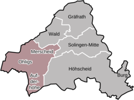
Location of the Aufderhöhe district in Solingen
|
|
|
At the height
|
|
Aufderhöhe is the most south-westerly district of the North Rhine-Westphalian city of Solingen . Together with the districts of Ohligs and Merscheid , it forms the most populous district of Ohligs / Aufderhöhe / Merscheid . The place name is usually on the syllable on and not stressed on the syllable height .
The namesake of today's district is the old Aufderhöhe court , which was first mentioned in the first half of the 17th century. From the 19th century on, Aufderhöhe was initially divided, from then on the north was under Merscheider / Ohligser administration, south, east and west under the Höhscheids . In the increasingly dense development, the boundaries between the two cities became increasingly blurred, and in 1929 the various individual cities became the new city of Solingen. The originally rural area of Aufderhöhes became one of the preferred residential areas in Solingen and since the post-war period numerous new building areas have emerged there, which today shape the image of the district.
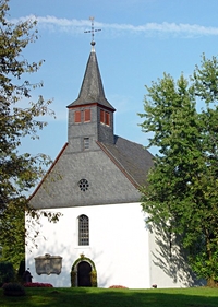
Aufderhöhe is best known for the St. Reinoldi Chapel in Rupelrath, whose roots are believed to be at the beginning of the 15th century.
geography
Aufderhoehe located in the west of the Süderbergland belonging means Bergisch plateaus . Devonian slate , greywacke and sandstones are overlaid by sand , gravel or gravel embankments from the main Rhine terrace. Today's part of the city originally consisted of several farms that were on and around the foothills of a ridge at about 100 to 130 meters above sea level. To the northwest the ridge falls to the Bergische Heideterrasse and thus to the Lower Rhine Bay .
Neighboring cities and districts
Aufderhöhe is located in the southwest of Solingen. Adjacent neighboring cities are in the south of Leichlingen in the Rheinisch-Bergisch district and in the west the city of Langenfeld in the district of Mettmann . In the north, the Solingen district of Ohligs borders Aufderhöhe, while Höhscheid and Aufderhöhe share a border in the east. The mean distance to Solingen city center is eight kilometers.
Residential quarters
Aufderhoehe has many residential areas , some of these residential areas are typical for the Bergisch land Hofschaften with only a few houses. The following list gives an overview of the majority of these residential areas. It is arranged alphabetically, additions to names such as lower or upper are omitted:
Aufderbech, Birkendahl, Börkhaus, Gosse, Horn, Holzhof, Josefstal, Landwehr, Neu-Löhdorf, Pohligsfeld, Riefnacken, Rupelrath, Siebels, Steinendorf, Ufer, Wiefeldick
history
prehistory
In the area of what is now the Aufderhöhe district, there are some finds from prehistoric times. Among them are the find of a Mesolithic living space east of the Birkendahl court . Several Neolithic individual finds were found north of Birkendahl . A find from the Bronze Age was made near the St. Reinoldi Chapel in Rupelrath.
Settlement origins up to the 18th century
The Bergisches Land remained uninhabited for a long time due to its dense forests and its sometimes demanding topography ; the Romans only penetrated as far as Cologne at that time. It was not until the 7th century that people spread to the areas on the other side of the Rhine that were more difficult to cultivate . With their settlement, the first monasteries were founded and the area was gradually Christianized .
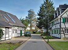
As in the entire Bergisches Land area, in Aufderhöhe there was mostly single farm settlements for centuries, which condensed into hamlets in suitable places , which in the Bergisches Land are typically called Hofschaften to this day. One of these court estates arose on the elevation between Landwehr and Hof Brücke south of Hackhausen , the geographical location brought the name on the height with it, which was mentioned in a document as early as 1642. In the map by Erich Philipp Ploennies from 1715 the place is mentioned as Höh . The remaining part of the Aufderhöhe Hofschaft with several listed half-timbered houses is today on a cul-de-sac off the Aufderhöher Straße, which bears the name Aufderhöhe .
On the trade route from Cologne or the Bergisches Hafen Hitdorf to Solingen, Wald and Gräfrath , Aufderhöhe, also often called Kölsche Höh , was the first stopping point after the steep rise from the Rhine plain. The route led over today's Opladener Straße via Löhdorfer and Mangenberger Straße to Solingen and Wald. There was a road customs office in Löhdorf .
Between 1752 and 1754 the new Rheinweg from Höhscheid to Aufderhöhe was built (today's federal road 229 ), which shifted the traffic; Löhdorfer Strasse lost its importance. The road customs office was moved from Löhdorf to the turnpike where the road from Brücke reached the height. For many years the area there was called Am Schlagbaum or An dr Gottemüöhl , named after the local Grützenmühle, which today still consists of the semi-detached houses on Aufderhöher Strasse 89 and 91. Under Napoleon , the new Rheinweg became a road by planting trees along the street. Because of this, for many years the legend lingered that Napoleon built this road first. One of the last of these trees was felled around 1985 at the level of the Aufderhöhe primary school due to a lack of stability.
Until 1806, Aufderhöhe belonged to the Honschaft Barl , as did Löhdorf, Steinendorf, zur Straßen and Küllenberg - which was mentioned for the first time in 980 - and thus to the parish of Wald; The border to the parish of Solingen was the Nacker Bach . Both parishes belonged to the Office of Solingen , which was one of 19 offices within the Duchy of Berg , which had been ruled by the Elector of Bavaria since 1742.
19th century
A remarkable development began for Aufderhöhe through the divisions of the Weltersbach estate and the division of the Richrath district, i.e. the area from the Gillich, the Landwehrberg, the Höher Heide and the Nussbaumstrasse to the beneficiaries of the neighboring courts. The previously leading court of Löhdorf lost more and more of its importance. In 1816 there were eight houses on Aufderhöher Strasse from Schlagbaum to Teschen Höh just before Landwehrberg, but in 1885 there were already over 50.
On March 15, 1806, Elector Maximilian IV Joseph ceded the Duchy of Berg to Napoleon . New administrative units were created. There was also an exchange between the parishes of Wald and Solingen, all of the courts south of Löhdorfer Strasse and west of today's Nussbaumstrasse were assigned to the parish of Solingen. On November 14, 1808, after the formation of the Mairien , i.e. the mayor's offices, the part that was formerly part of the Solingen parish came to the new Mairie Höhscheid, the other part to the new Mairie Merscheid, which was renamed Ohligs as the township on August 31, 1891 . After the Grand Duchy of Berg fell to the Kingdom of Prussia as a result of the Congress of Vienna, the Mairien were renamed mayor's offices, which were then elevated to municipalities with the decree of the Rhenish City Code of May 15, 1856.
In 1828 104 people lived in the Aufderhöhe estate. In 1832 there were 125, in 1871 already 345. In 1895 the court had 506 inhabitants and was thus the second most densely populated court in Höhscheid after Unterwiddert.
The old Barl Honnschaftsschule was located in Löhdorf, the building of which is today's house at Löhdorfer Straße 299, until a new school was built in Neu-Löhdorf in 1822 - today's House of Youth on Friedenstraße. Until 1895 the children from the separated parts of the community went to school in Neu-Löhdorf (so-called percentage school), until a new school was built in Aufderhöhe.
Around 1800 there were three farms in Aufderhöhe, some of which were badly damaged by French troops marching through. A little later there were five or six who increasingly attracted social life. So the Rupelrath funfairs also shifted more and more to the Aufderhöhe area. These economies soon formed the bases of the various associations that had emerged in Aufderhöhe over the years. Above all, however, when the landlord Ferdinand Hinrichs, after winning the lottery, added a spacious hall to his inn, today's Bergischer Hof, around 1870, and the landlord Makebach on the corner of Aufderhöher and Löhdorfer Strasse soon followed him. But also the restaurant of Carl Julius Makebach, today's restaurant Zur Post and the restaurant in Lüttges were popular meeting places.
In 1844, the previous mail collection point in Aufderhöhe became a postal expedition . The express mail from Berlin to Cologne, which had been running via Aufderhöhe since 1841 , was discontinued in 1844 and the postal service in 1847, but the personal mail from Solingen via Aufderhöhe to Langenfeld continued until 1905. From 1913 on, the electric tram from Höhscheid to Landwehr, the Landwehrbahn, existed.
Between 1864 and 1867, the Bergisch-Märkische Eisenbahn-Gesellschaft had the railway line between Deutz and Gruiten built, which at Landwehr also ran through Höhscheid. In 1894, the Landwehr railway station opened between the Ohligs and Leichlingen stations , with which the town of Höhscheid was first connected to the railway network. Located far from the Höhscheid center, it had little use for the local economy.
20th century until today
Not least because of its central location, the Hofschaft Aufderhöhe became the center of the entire area over time, the border between the city of Höhscheid and the city of Ohligs was hardly perceived as such, apart from the fact that different schools were attended and some their taxes to the Solingen tax office, which others had to bring to Ohligs. Due to the city union in 1929, they moved even closer together.
Today's Autobahn 3 between Langenfeld and Hilden was built in 1936, which also runs over Solingen's urban area in the far west. The Solingen motorway junction in Langenfeld- Wiescheid , near the city limits of Aufderhöhe, was inaugurated in the same year.
In March / April 1945 General Field Marshal Walter Model had his headquarters for a few days in the Ruhr area in Aufderhöhe. Shortly afterwards, Solingen was liberated by the Americans .
In the post-war period , some new building areas were built around the old Aufderhöher core. These are, for example, the settlement on Goldberger Weg and Höher Heide, in Löhdorf, on Wiefeldick, as well as new industrial and commercial areas such as the one on Höhscheider Weg. Large retail groups settled on Friedenstrasse. The old Catholic church on Wiefeldicker Strasse was demolished after being destroyed in the war in 1960. The new Catholic Church of Our Lady was built at the same location, the foundation stone of which was laid on June 26, 1960, and the church was inaugurated on December 24, 1960.
In 1976 politicians discussed building a four-lane arterial road through Aufderhöhe. The first and only expansion can still be seen today on the Schwarze Pfähle road. The further expansion should then continue on the Friedenstrasse, Löhdorfer, Aufderhöher and Landwehrstrasse. It was believed at the time that Solingen would soon have 220,000 inhabitants. By contrast, there are actually around 160,000 today. In addition to many buildings, the Bergischer Hof restaurant in the Aufderhöher town center would also have fallen victim to the expansion. In contrast to the plans at the time, Aufderhöher Strasse was then dismantled from the bridge to the confluence of Löhdorfer Strasse from 1994 and from there to the entrance to the village on Landwehrberg, for which traffic was massively hindered for about three years. As part of the dismantling work, the new Aufderhöher bus station was inaugurated on September 1, 2003.
In 1993 the Solingen trolleybus network was comprehensively expanded for the last time. In the course of this, lines 685 and 686 were electrified, which, according to different routes, converge in the city center along Mangenberger Straße and have their final stop in Aufderhöhe. The inauguration of the lines was celebrated on August 22, 1993.
After the stormy development since the 1950s with brisk construction activity, the influx of a large number of new Aufderhöhern and the settlement of factories, companies and large department stores, Aufderhöhe is now understood to mean the entire district in which the old courts, which were once the hallmark of this rural area have almost disappeared due to the dense development. Since the green predominates in the district, the spa town of Aufderhöhe is sometimes used .
From 1999 the savings and construction association Solingen built a new large housing estate in the west of Aufderhöhe on Börkhauser Feld. The most recent housing development project is the new Am Siebels development , which was completed in 2018.
economy
As top throughout the county Solingen was in the Hofschaften of Aufderhöher space the blades craft investigated. In the early days it was mainly swords and other edged weapons that the grinders produced in their kotten along the numerous streams and exported to all of Central Europe. Over the centuries the swords lost their importance; Knives, cutlery and scissors took their place and in turn vouched for the quality of Solingen steel goods. Some companies in the branch are still based in Aufderhöhe. These include Felix Solingen, Puma , Herbertz , Kretzer Scheren, Triangle and Gebrüder Stamm.
There are some commercial and industrial areas around Aufderhöhe, such as An den Eichen, Schorberger Straße, Höhscheider Weg or the Schmalzgrube. Many Aufderhöher companies are also located on Höhenückenstrasse to Solingen, Löhdorfer and Mangenberger Strasse. Sectors other than the cutlery industry have now also gained a foothold at Aufderhöhe. For example, item Industrietechnik , Küchenprofi, gesta-direktwerbung and Herbert Schmidt Oberflächentechnik (HSO) are also based in Aufderhöhe. The largest employer in the district, however, is the Diakonisches Werk Bethanien, which runs a specialist clinic for pulmonary medicine with the Bethanien Hospital on Aufderhöher Strasse .
Transport and infrastructure
traffic
The next motorway junction, Solingen, is located one kilometer southwest of Landwehr on the A3 in the area of the city of Langenfeld . Since the Langenfelder Kreuz junction is also directly connected to the Solingen junction , the A 542 can also be reached in this way . The Hildener Kreuz (A 3 / A 46 ) with the Hilden exit is about ten kilometers northwest of Aufderhöhe. The federal road 229 runs on its way from Langenfeld to Höhscheid via Aufderhöhe.
Several bus routes, some of which are operated by trolleybuses , connect Aufderhöhe with Solingen-Mitte, the other districts and the surrounding towns. The central transfer point is the Aufderhöher bus station.
Infrastructure
In addition to a few kindergartens, there is also a municipal primary school in Aufderhöhe . There are several churches in Aufderhöhe: the Catholic Church of Our Lady on Wiefeldick, the Evangelical Church of Peace in Löhdorf, the Evangelical Church on Opladener Straße and the St. Reinoldi Chapel in Rupelrath.
In Aufderhöhe the Diakonisches Werk Bethanien operates the Bethanien Hospital as a specialist clinic for pulmonary medicine and a center for sleep and respiratory medicine. The fire fighting unit 2 of the Solingen volunteer fire brigade has its own fire station in Rupelrath .
Sport, culture and leisure
In Aufderhöhe are among other things the TSV Solingen-Aufderhöhe 1877 eV . as well as the Schützenverein 1885 e. V. Solingen-Aufderhöhe resident.
With the St. Reinoldi Chapel in Rupelrath, there is a chapel in Aufderhöhe that dates back to the 14th century .
Festivals
Highlights of the year are at the end of June / beginning of July the fire brigade garden party of the volunteer fire brigade extinguishing unit 2, the parish festival of the Catholic parish of Liebfrauen on the last Sunday before the summer holidays, the parish festival of the Protestant parish Rupelrath and the rifle and public festival on the first Sunday in September.
Web links
- Private portrait of the district on solingen-internet.de
literature
- Hans Grah: Foray through the history of Aufderhöhes. Solingen 1977.
- Michael Stamm: Club chronicle for the 125th anniversary of the Schützenverein 1885 e. V. Solingen-Aufderhöhe. Solingen 2010.
- Reinhold Kaiser (edit.): Rheinischer Städteatlas Höhscheid. Serial VIII, No. 45, Rheinland-Verlag Cologne 1985, ISBN 3-7927-0830-2 .
- Elisabeth Reuß (arrangement): Rhenish city atlas of Ohlig. Lfg. XII, No. 66, Rheinland-Verlag, Cologne 1996, ISBN 3-7927-1565-1 .
swell
- ↑ Solinger Tageblatt. August 4, 2015, p. 19.
- ↑ a b c d e f Rheinischer Städteatlas Höhscheid ; Lfg. VIII No. 45, 1985; Editor: Reinhold Kaiser; Rheinland-Verlag Cologne, ISBN 3-7927-0830-2 .
- ↑ Rheinischer Städteatlas Ohligsberg ; Lfg. XII No. 66, 1996; Editor: Elisabeth Reuß; Rhineland publishing house Cologne
- ↑ Hans Brangs: Explanations and explanations for the corridor, place, yard and street names in the city of Solingen. Solingen 1936.
- ↑ a b c d e f g h Michael Stamm: Club chronicle for the 125th anniversary of the shooting club 1885 e. V. Solingen-Aufderhöhe , Solingen 2010
- ^ A b Hans Grah: Foray through the history of Aufderhöhe. Solingen 1977.
- ^ Marina Alice Mutz: Church buildings in the Bergisches Land. In: Time Track Search. Retrieved May 4, 2016 .
- ↑ a b Ralf Rogge, Armin Schulte, Kerstin Warncke: Solingen - Big City Years 1929-2004 . Wartberg Verlag, 2004, ISBN 3-8313-1459-4 .
- ↑ a b Portrait of the Bethanien Hospital ( Memento of the original from April 25, 2017 in the Internet Archive ) Info: The archive link has been inserted automatically and has not yet been checked. Please check the original and archive link according to the instructions and then remove this notice. on klinik-bethanien.de , accessed on April 18, 2016.


