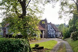
Belt mill
|
Belt mill
City of Solingen
Coordinates: 51 ° 12 '26 " N , 7 ° 3' 56" E
|
||
|---|---|---|
| Height : | about 200 m | |
| Postal code : | 42653 | |
| Area code : | 0212 | |
|
Location of Bandesmühle in Solingen |
||
|
Belt mill
|
||
The band mill is a former mill in the Gräfrath district of the Bergisch city of Solingen .
geography
The band mill is located west of the town center of Graefrath, from which the embankment of the corkscrew railway separates the mill. It is located on the Itter , which, after being piped below the old town of Gräfrath, runs back to the surface shortly before the belt mill. West of the mill stems from the Bandesmühler Bach , who a little later in the Itter flows . To the northwest of the Bandesmühle is the Blumental location , to the south is the Gräfrather Parkfriedhof and the Ziegelfeld location and to the southwest is the Mühlenbusch location .
etymology
The gang mill is in the bonds , so in the wet meadow , located mill in the valley.
history
The mill was first mentioned in 1492 in the Gräfrath estimate book, in which a miller named ter Moelen ran it . The former water-powered grain mill belonged to the Gräfrath monastery for a long time . The mill is listed in the map series Topographia Ducatus Montani by Erich Philipp Ploennies , Blatt Amt Solingen , from the year 1715 without a name. She belonged to the Honschaft Gräfrath within the office of Solingen . The topographical survey of the Rhineland from 1824 and the Prussian first survey from 1843 also show the mill without any labels. One of the owners of the mill in the 19th century was Wilhelm Köttgen. When the latter wanted to sell the mill, he invited the presumed buyer, Robert Jacobs, to visit it. On this day he also invited all the Graefrath farmers to have their grain milled by him free of charge. The resulting large influx allegedly impressed Jacobs in such a way that he bought the mill.
After the establishment of the Mairien and later mayor's offices at the beginning of the 19th century, the band mill belonged to the Gräfrath mayor's office . In 1815/16 eight residents lived in the town, also in 1830. In 1832 the town was still part of the Gräfrath Honschaft within the Gräfrath mayor. The place, which was categorized as a mill and arable property according to the statistics and topography of the Düsseldorf administrative district , had a residential building, a mill and an agricultural building at that time. At that time, eight residents lived in the place, four of them Catholic and four Protestant denominations. The municipality and estate district statistics of the Rhine Province list the place in 1871 with one house and six residents. In the municipality lexicon for the Rhineland province from 1888, a house with 17 inhabitants is given for the place. In 1895 the district owned a house with twelve inhabitants, in 1905 one house and eight inhabitants are given.
In 1887, the Solingen-Wuppertal-Vohwinkel railway line was laid on a dam directly past the village . To the east of the mill was a mill pond that was later drained. Today a small cul-de-sac from Oberhaaner Strasse called Mühlenteich reminds of this place. The water wheel of the mill was demolished in 1919 in a damaged condition. The Itter runs today in the former upper ditch of the mill. With the town union of Groß-Solingen in 1929, the band mill became part of Solingen. The former mill building, a two-storey half-timbered house with the address gang mill 1, is since 27 November 1984 under monument protection .
swell
- ^ City of Solingen: Street and place names in our city of Solingen , self-published, Solingen 1972
- ↑ a b Axel Birkenbeul: Mühlen, Kotten and Hämmer in Solingen , Erfurt: Suttonverlag, 2014, ISBN 978-3-95400-467-6
- ^ A b Friedrich von Restorff : Topographical-statistical description of the Royal Prussian Rhine Province , Nicolai, Berlin and Stettin 1830
- ↑ a b Johann Georg von Viebahn : Statistics and Topography of the Administrative District of Düsseldorf , 1836
- ↑ Royal Statistical Bureau Prussia (ed.): The communities and manor districts of the Prussian state and their population . The Rhine Province, No. XI . Berlin 1874.
- ↑ Königliches Statistisches Bureau (Prussia) (Ed.): Community encyclopedia for the Rhineland Province, based on the materials of the census of December 1, 1885 and other official sources, (Community encyclopedia for the Kingdom of Prussia, Volume XII), Berlin 1888.
- ↑ Königliches Statistisches Bureau (Prussia) (Ed.): Community encyclopedia for the Rhineland Province, based on the materials of the census of December 1, 1895 and other official sources, (Community encyclopedia for the Kingdom of Prussia, Volume XII), Berlin 1897.
- ↑ Königliches Statistisches Bureau (Prussia) (Ed.): Community encyclopedia for the Rhineland Province, based on the materials of the census of December 1, 1905 and other official sources, (Community encyclopedia for the Kingdom of Prussia, Volume XII), Berlin 1909.
- ↑ Solingen Monument List ( Memento from December 18, 2015 in the Internet Archive ). City of Solingen, July 1, 2015, accessed on June 26, 2016 (PDF, size: 129 kB).

