
Blumental (Solingen)
|
Flower valley
City of Solingen
Coordinates: 51 ° 12 ′ 30 ″ N , 7 ° 3 ′ 42 ″ E
|
||
|---|---|---|
| Height : | about 200 m | |
| Postal code : | 42653 | |
| Area code : | 0212 | |
Location of Blumental in Solingen |
||
 Flower valley
|
||

Blumental is a location in the mountainous city of Solingen .
geography
Blumental is located on the Itter in the Gräfrath district between Eipaß and Bandesmühle at about 200 meters above sea level . To the north is Grund , to the south is Neu-Eipaß and Mühlenbusch . The buildings belonging to the local situation can be reached via a small cul-de-sac from Oberhaaner Straße. North the old railway embankment leads the so-called corkscrew path to the living space over, now used as a footpath corkscrew route .
history
The location of Blumental was probably not created until the second half of the 19th century. The topographical survey of the Rhineland from 1824, the Prussian first survey from 1843 and the topographical map of the Düsseldorf administrative district from 1871 do not record the location.
In the municipality lexicon for the Rhineland province in 1885, a house with four residents is given. In 1895 the district owned a house with twelve inhabitants, in 1905 one house and six inhabitants are given. With the town union of Groß-Solingen in 1929, Blumental became a district of Solingen.
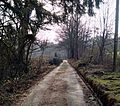
Access to the flower valley

Landscape in the flower valley


Web links
swell
- ^ Topographic map of the Düsseldorf administrative district . Designed and executed according to the cadastral recordings and the same underlying and other trigonometric work by the Royal Government Secretary W. Werner. Edited by the royal government secretary FW Grube. 4th rev. Edition / published by A. Bagel in Wesel, 1859 / Ddf., Dec. 17, 1870. J. Emmerich, Landbaumeister. - Corrected after the ministerial amendments. Ddf. d. Sept. 1, 1871. Bruns.
- ↑ Königliches Statistisches Bureau (Prussia) (Ed.): Community encyclopedia for the Rhineland Province, based on the materials of the census of December 1, 1885 and other official sources, (Community encyclopedia for the Kingdom of Prussia, Volume XII), Berlin 1888.
- ↑ Königliches Statistisches Bureau (Prussia) (Ed.): Community encyclopedia for the Rhineland Province, based on the materials of the census of December 1, 1895 and other official sources, (Community encyclopedia for the Kingdom of Prussia, Volume XII), Berlin 1897.
- ↑ Königliches Statistisches Bureau (Prussia) (Ed.): Community encyclopedia for the Rhineland Province, based on the materials of the census of December 1, 1905 and other official sources, (Community encyclopedia for the Kingdom of Prussia, Volume XII), Berlin 1909.
Altenfeld | Apple tree | Aue | Belt mill | Bergerbrühl | Bimerich | Flower valley | Bush | Buscher field | Third Kotten | Dyck | Corner stump | Egidius Klusen | Honor | Flockertsberg | Flockert wood | Foche | Focher Dahl | Freudenberg | Peace Valley | Grünewald | Reason | Heather | Heider Hof | Ketzberg | Kohlfurther Eickholz | Külf | Laiken | Mühlenbusch | Neuenhaus | New bull | Nümmen | Obenflachsberg | Up to the wood | Paashaus | Piepersberg | Rauenhaus | Rathland | Ringhouse | Sheep House | Schieten | Turnpike | Scheiderirlen | Schönhof | Steinbeck | Stone house | Stone sieving | Stöckerberg | I. Stockdum | II. Stockdum | III. Stockdum | Tummelhaus | Unterflachsberg | Down to the wood | Central | Ziegelfeld (East) | Ziegelfeld (south)