
Kohlfurth (Solingen)
|
Kohlfurth
City of Solingen
Coordinates: 51 ° 11 ′ 22 " N , 7 ° 6 ′ 36" E
|
||
|---|---|---|
| Height : | about 115-130 m | |
| Postal code : | 42651 | |
| Area code : | 0212 | |
Location of Kohlfurth in Solingen |
||
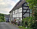
 Kohlfurth with the Café Hubraum
|
||

Kohlfurth is a district of the Bergisch city of Solingen . The Hubraum café, located in a mountainous half-timbered house in Kohlfurth, is known nationwide and is particularly popular with motorcyclists .
Location and description
Kohlfurth is located in the northwest of the Solingen district of Mitte on the western bank of the Wupper near the border with the district of Gräfrath . The Solingen-Kohlfurth junction of Landesstraße 74 (L 74) is on the outskirts of the village . In the Kohlfurth area, the L 74 has been expanded into a four-lane motor vehicle and limits the district through its course to the west and south.
The district is spanned twice with bridges at the level of Kohlfurther Straße and Kohlfurth Straße . Kohlfurth is connected to the Kohlfurtherbrücke residential area in Wuppertal via the Kohlfurther Bridge , which crosses the Wupper as a former tram bridge near the Café Hubraum .
South of Kohlfurth is the Hofschaft and the large housing estate Hasseldelle . To the west lie Schrodtberg with the industrial area Schrodtberg, Stöcken and the Fleußmühle . To the north are the Kohlfurther Eickholz desert and the Aue area . To the south-east of the Wuppertal urban area are the courts of Ober- and Unterkohlfurth . These are located in the Kohlfurth residential area of the Cronenberg district .
etymology
The origin of a possible determinant cabbage in the court name has not been conclusively clarified. According to Brangs, the coal supply from the Ruhr area to Solingen ran through the place for a while, but the place can be proven to have existed as early as the second half of the 14th century, so the name Kohlfurth is older than any coal consumption. He also suspects that a Wupper ford could give the second part of the name its name. There may also be entanglements with the court name Külf . The most likely origin is the derivation of a farm name after the Külfbach, which flows into the Wupper near Kohlfurth. In 1471, the courtyard becomes “in der Kolve” ; 1598 Kulfert ; 1656 Kullff ; 1659 Kolfert ; 1690 Kolffurt noted. Kolf, Kolve or Külf means water hole .
history
Kohlfurth existed as a court at least in 1363. This year the place was first mentioned in a document. In the map series Topographia Ducatus Montani by Erich Philipp Ploennies , Blatt Amt Solingen , from the year 1715, the place is recorded with a farm and named as Colfert . The court belonged to the Honschaft Solingen within the office of Solingen. The topographical survey of the Rhineland from 1824 lists the place as Kolfurt and the Prussian first survey from 1844 as Kohlfurth. In the topographic map of the Düsseldorf administrative district from 1871, the place is recorded as Kolfert .
After the founding of mairies and later mayors early 19th century Kohlfurth belonged to Honschaft Dorp the mayoralty Dorp . In 1815/16 there were 125 inhabitants, in 1830 139 people lived in the place categorized as a hamlet . In 1832 Kohlfurth was still part of the Dorp Honschaft within the Dorp mayor. The place, which was categorized as a court town according to the statistics and topography of the Düsseldorf administrative district , had 20 residential houses, twelve factories or mills and 16 agricultural buildings under the name Kolfert at that time . At that time, 156 residents lived in the village, all of whom were evangelicals. The municipality and manor district statistics of the Rhine Province list the place in 1871 with 28 houses and 264 inhabitants. In the municipality lexicon for the province of Rhineland , 38 houses with 217 inhabitants are listed in 1885.
In the 19th century, the Kohlfurther Straße running through the village was expanded to become the Provincial Road Elberfeld – Hitdorf , which connected the city of Elberfeld via Solingen with the Rhine port in Hitdorf before there were rail links in the region. The mayor's office or city of Dorp was merged with the city of Solingen in 1889. This made Kohlfurth a district of Solingen. In 1895 the district had 34 houses with 236 inhabitants, in 1905 32 houses and 221 inhabitants are given.
From 1914, a meter-gauge tram ran through Kohlfurth from Cronenberg to Solingen, which crossed the Wupper via the Kohlfurther bridge. The line was operated until 1969 and designated as line 5. At the Kohlfurther bridge in Wuppertal living space Kohlfurther Bridge , the club operates Bergische Museum lanes e. V. the Bergisches Straßenbahnmuseum (BSM). A few last remains of the tram track are still on the Solingen side between the Kohlfurther bridge and the Café Hubraum.
The L 74 was built in the early 1970s from Müngsten in the direction of the Sonnborner Kreuz , a first section from Müngsten to Kohlfurth was opened on September 5, 1973, the remainder of the route, with the Wupper crossing at Kohlfurther Eickholz, took place until 1975. Since September 18, 1984, the large historic half-timbered house Kohlfurth 37 from 1615, with its partly slated and shingled exterior facade, has been a listed building .

Residential houses in Kohlfurth

Building monument Kohlfurth 37

Residential houses in Kohlfurth
Residential houses in Kohlfurth
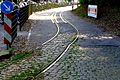
Tram rails at the Café Hubraum

Kohlfurther Bridge


Web links
- Hans-Georg Wenke: My Solingen / Kohlfurth on solingen-internet.de
swell
- ^ Biker meeting in the Kohlfurth. (No longer available online.) In: Solinger Morgenpost. May 19, 2012, archived from the original on August 23, 2016 ; accessed on August 23, 2016 . Info: The archive link was inserted automatically and has not yet been checked. Please check the original and archive link according to the instructions and then remove this notice.
- ^ Wolfgang Stock: Wuppertal street names . Thales Verlag, Essen-Werden 2002, ISBN 3-88908-481-8
- ↑ a b Hans Brangs: Explanations and explanations for the corridor, place, yard and street names in the city of Solingen . Solingen 1936
- ^ Topographic map of the Düsseldorf administrative district . Designed and executed according to the cadastral recordings and the same underlying and other trigonometric work by the Royal Government Secretary W. Werner. Edited by the royal government secretary FW Grube. 4th rev. Edition / published by A. Bagel in Wesel, 1859 / Ddf., Dec. 17, 1870. J. Emmerich, Landbaumeister. - Corrected after the ministerial amendments. Ddf. d. Sept. 1, 1871. Bruns.
- ↑ Johann Georg von Viebahn : Statistics and Topography of the Administrative District of Düsseldorf , 1836
- ↑ Friedrich von Restorff : Topographical-statistical description of the Royal Prussian Rhine Province , Nicolai, Berlin and Stettin 1830
- ↑ Friedrich von Restorff : Topographical-statistical description of the Royal Prussian Rhine Province , Nicolai, Berlin and Stettin 1830
- ↑ a b Johann Georg von Viebahn : Statistics and Topography of the Administrative District of Düsseldorf , 1836
- ↑ Royal Statistical Bureau Prussia (ed.): The communities and manor districts of the Prussian state and their population . The Rhine Province, No. XI . Berlin 1874.
- ↑ Königliches Statistisches Bureau (Prussia) (Ed.): Community encyclopedia for the Rhineland Province, based on the materials of the census of December 1, 1885 and other official sources, (Community encyclopedia for the Kingdom of Prussia, Volume XII), Berlin 1888.
- ↑ Königliches Statistisches Bureau (Prussia) (Ed.): Community encyclopedia for the Rhineland Province, based on the materials of the census of December 1, 1895 and other official sources, (Community encyclopedia for the Kingdom of Prussia, Volume XII), Berlin 1897.
- ↑ Königliches Statistisches Bureau (Prussia) (Ed.): Community encyclopedia for the Rhineland Province, based on the materials of the census of December 1, 1905 and other official sources, (Community encyclopedia for the Kingdom of Prussia, Volume XII), Berlin 1909.
- ↑ Ralf Rogge, Armin Schulte, Kerstin Warncke: Solingen - Big City Years 1929-2004 . Wartberg Verlag, 2004, ISBN 3-8313-1459-4 , p. 49.
- ↑ Solingen Monument List. ( Memento of the original from December 18, 2015 in the Internet Archive ) Info: The archive link was inserted automatically and has not yet been checked. Please check the original and archive link according to the instructions and then remove this notice. (PDF; 129 kB) City of Solingen, July 1, 2015; Retrieved June 5, 2016.
Altenbau | Stop cap | Arnsberger Kotten | Auer Kotten | I. Balkhausen | II. Balkhausen | III. Balkhausen | Balkhauser Kotten | Mug house | Amber house | Bertramsmühle | Bilsteiner Kotten | Birch trees | Birmingham | Buck | Böckerhof | Breidbach | Bünkenberg | Dornsiepen | Dorperhof | Eichholz | Eick | Elsterbusch | Heir house | Donkey | Eulswag | I. field | II. Field | III. Field | IV. Field | Rock cellar | Fleußmühle | Glüder | Grünental | Grunenburg | I. Hästen | II. Chesting | III. Hate | Hip | Height | Hohenscheid | Irlen | Jagenberg | Kannenbrühl | Kannenhof | Kempen | Kirberg | Kirchbaumshöh | Kirchbaumskotten | Kirchberger Kotten | Klauberg | In the Klauberg | To Klauberg | Königskotten | Königsmühle | Kohlfurth | Crow height | Linden tree | Mouse height | Meigen | Meigenerbrühl | Meisenburg | Obendahl | Obenweeg | Odental | Paper mill | Papiermühlerbach | Pereskotten | Petersmühle | Pfaffenberg | Potshaus | Schaberg | Soundbreak mill | Switch caps | Scharfhausen | Schellberg | Schlicken | Schrodtberg | Schützenfeld | Schützenhöhe | School bushes | Backlash break | Städtgesmühle | Stone sieving | Sticks | Stöckerberg | Strohnerbach | Storm hole | Fir tree | Theegarten | Unnersberg | Downhill | Vockert | Vockerterbusch | White horse | Werewolf | Wieden | Wiedenhof | Wiesenkotten | Diapers | Windfelnerhof | Desert farm