
Kohlfurth (district)
|
district of Wuppertal |
|
|---|---|
 |
|
| Coordinates | 51 ° 11 '36 " N , 7 ° 6' 36" E |
| height | 198 m above sea level NHN |
| surface | 1.12 km² |
| Residents | 497 (December 31, 2016) |
| Population density | 444 inhabitants / km² |
| Proportion of foreigners | 5.6% (Dec. 31, 2016) |
| Post Code | 42349 |
| prefix | 0202 |
| Borough | Cronenberg |
| Transport links | |
| tram | Bergisches Tram Museum |
| bus | 605 CE64 AST64 |
| Source: Wuppertal statistics - spatial data | |
Kohlfurth (often also Kohlfurt ) is a residential area in the Wuppertal district of Cronenberg on the border with Solingen formed by the Wupper . On the opposite side of the Wupper there is a location of the same name in the Solingen district of Solingen-Mitte.
etymology
There are two interpretations of the etymological origin of the name. The first says that the name comes from a coal furth, i.e. a ford through the Wupper, on which coal was transported from the Ruhr to Solingen. The more likely one is the derivation of a farm name after the Külfbach, which flows into the Wupper near Kohlfurth. In 1471, the courtyard becomes “in der Kolve” ; 1598 Kulfert ; 1656 Kullff ; 1659 Kolfert ; 1690 Kolffurt noted. Kolf, Kolve or Külf means water hole.
description
Wuppertal-Kohlfurth is divided into three parts. At the height of Kohlfurther bridge , the local situation is Kohlfurther bridge , something wupper down is lower Kohlfurth called Branch bulk is due to the serpentine stretch to Berghausen on the Cronenberger ridge top Kohlfurth .
A wooden predecessor of the Kohlfurther Bridge was first mentioned in a document in 1363. The deed mentions the sale of the Bergisch count house “Hof Solingen” with all rights, including the “fishing in the Wipperen boeven der Kolferder bruggen”, to the Abbey of Altenberg . Two hammer mills are also documented in 1694 . This later became Schleifkotten , in which the first steam boiler system in the Cronenberg area was installed. In addition to the bridge, some residential buildings from the first half of the 19th century have been placed under monument protection.
On the Kaltenbach , a tributary of the Wupper, there were six water drives , including the Kaltenbacher Hammer and the Manuelskotten Grinder Museum , a branch of the Wuppertal Historic Center . The Werther Kotten , one of the two Cronenberger Schleifkotten on the Wupper, was located on the Wupper at the height of today's sewage treatment plant .
From 1914, the meter-gauge tram from Cronenberg to Solingen also ran over the Kohlfurth Bridge, and the line was operated as line 5 until 1969. At the Kohlfurther bridge, the association “Bergische Museumsbahnen e. V. “the Bergisches Straßenbahnmuseum (BSM) and runs a museum tram on certain days on a section of the old tram route through the Kaltenbachtal.
The Kohlfurth is accessed from the state road 74 , which leads from the Sonnborner Kreuz along the Wupper through Burgholz to here. Solinger Strasse on the Jacobsberg from Cronenberg and Cronenberger Strasse from Solingen to Kohlfurth follow a historical path . It is shown as state road 427 .
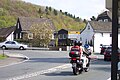
The catering establishments Café Hubraum (in Solingen) and the Strandcafe are popular nationwide . They are the destination of numerous motorized two-wheelers from all over the Bergisch area .

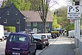
Northern approach to Kohlfurth
At the intersection to Cronenberg
Right to the Kohlfurther bridge, in the background the beach café

Elaborately designed entrance of a house in the Bergisch style


Individual evidence
- ↑ a b Wolfgang Stock: Wuppertal street names . Thales Verlag, Essen-Werden 2002, ISBN 3-88908-481-8
Web links
- Architectural monument overview Kohlfurth in the Wuppertal monument list
- Wenke: My Solingen / Kohlfurth

District 0 Elberfeld : 00 Elberfeld-Mitte | 01 Nordstadt | 02 Easter tree | 03 Südstadt | 04 Grifflenberg | 05 Friedrichsberg
District 1 Elberfeld-West : 10 Sonnborn | 11 Varresbeck | 12 Nützenberg | 13 Brill | 14 Arrenberg | 15 zoo | 16 Buchenhofen
District 2 Uellendahl-Katernberg : 20 Uellendahl-West | 21 Uellendahl-Ost | 22 Dönberg | 23 Nevigeser Strasse | 24 Beek | 25 corner bush | 26 Siebeneick
district 3 Vohwinkel : 30 Vohwinkel-Mitte | 31 Osterholz | 32 Tesche | 33 Schöller-Dornap | 34 Lüntenbeck | 35 Industriestrasse | 36 West Ring | 37 height | 38 Schrödersbusch
District 4 Cronenberg : 40 Cronenberg-Mitte | 41 Küllenhahn | 42 Hahnerberg | 43 Cronenfeld | 44 Berghausen | 45 Sudberg | 46 Kohlfurth
district 5 Barmen : 50 Barmen-Mitte | 51 Friedrich-Engels-Allee | 52 Loh | 53 Clausen | 54 Rott | 55 Sedansberg | 56 Hatzfeld | 57 Kothen | 58 Hesselnberg | 59 Lichtenplatz
District 6 Oberbarmen : 60 Oberbarmen-Schwarzbach | 61 Wichlinghausen-Süd | 62 Wichlinghausen-North | 63 NEXT BECK-East | 64 NEXTBreck-West
district 7 Heckinghausen : 70 Heckinghausen | 71 Heidt | 72 Hammesberg
District 8 Langerfeld-Beyenburg : 80 Langerfeld-Mitte | 81 Rauental | 82 Jesinghauser Strasse | 83 Hilgershöhe | 84 Löhrerlen | 85 Fleute | 86 Ehrenberg | 87 Beyenburg-Mitte | 88 Herbringhausen
District 9 Ronsdorf : 90 Ronsdorf-Mitte / Nord | 91 Blombach-Lohsiepen | 92 Rehsiepen | 93 Schenkstrasse | 94 Bloodfinches | 95 Erbschlö-Linde