
Elberfeld-West
 district of Wuppertal |
|||||||||||||
|---|---|---|---|---|---|---|---|---|---|---|---|---|---|
 |
|||||||||||||
| Coordinates | 51 ° 15 '8 " N , 7 ° 6' 39" E | ||||||||||||
| height | 129- 303 m above sea level. NHN | ||||||||||||
| surface | 10.37 km² | ||||||||||||
| Residents | 27,478 (Dec. 31, 2014) | ||||||||||||
| Population density | 2650 inhabitants / km² | ||||||||||||
| Proportion of foreigners | 17.3% (Dec. 31, 2014) | ||||||||||||
| prefix | 0202 | ||||||||||||
| politics | |||||||||||||
| Allocation of seats (district representation) | |||||||||||||
|
|||||||||||||
| Transport links | |||||||||||||
| Highway |
|
||||||||||||
| Federal road |
|
||||||||||||
| railroad | RB 48 | ||||||||||||
| Train | S 8 S 9 | ||||||||||||
| Local transport | Suspension railway | ||||||||||||
| Source: Wuppertal statistics - spatial data | |||||||||||||
Elberfeld-West has been a district of Wuppertal since 1929 and belongs to the largest district of Elberfeld . Elberfeld-West consists of the western suburbs of the old town of Elberfeld and the incorporated town of Sonnborn .
The districts of Elberfeld and Uellendahl-Katernberg also belong to the Elberfeld district . The Elberfeld-West area includes the Wuppertal Zoo and the Stadion am Zoo .
geography
Elberfeld-West lies on both sides of the Wupper in the valley floor and on the slopes of the mountains Nützenberg (also Briller Berg ) in the north and Kiesberg (whose northern slope Arrenberg ) in the south. At Sonnborn, the Wupper turns south and continues towards Solingen.
Division into quarters
|
District 1 Elberfeld-West
|

|
Sonnborn
history
The name Sonnborn means sun well and suggests a pagan place of worship.
Sonnborn is known as the oldest settlement in the area of today's Wuppertal. It was first mentioned in 874. Sonnborn was a Frankish outpost in the border area between Franconia and Saxony .
More recently, Sonnborn has been considered the western Elberfeld outpost for centuries . It belonged alternately to Elberfeld, Solingen or Haan , but formed an independent mayor's office from 1867 to 1888 before it was finally incorporated into Elberfeld.
In 1992 Sonnborn, especially the area of the corner bar “Alt-Sonnborn”, was used for outdoor shots for the children's series “ The Little Vampire - New Adventure ” .
Culture and sights
Buildings
The large Protestant main church in Sonnborn on Sonnborner Strasse was consecrated in 1926 after the previous church was destroyed by fire in 1917. The church has large slated hipped roofs with baroque tail gables, a tower made of gray quarry stone typical of the area with tracery crowning and an elaborate staircase with wrought iron railings and lantern stands that has been preserved since the time it was built. The almost ten-year construction period led to an exciting juxtaposition of different styles. The roof area is designed in the Bergisches Heimat style and the quarry stone areas can be assigned to the restrained reform construction of this time, while Expressionism can already be heard in the elaborate tracery and the sandstone decorative elements of the tower. Two bells from the 15th century are among the oldest preserved bells in the Bergisch area.
In 1992 the church was placed under monument protection. 2006 extensive restoration of the historical " Faust- Organ". Installation of a “family church” under the gallery, for which the municipality and Ahad architects Braunschweig received the 2007 architecture prize “Award for Good Buildings” from the Association of German Architects in Wuppertal.
traffic

Sonnborn lies on the Wuppertal valley axis. Seen from the suspension railway stop Vohwinkel, the station Sonnborner Straße is the third. Sonnborn also has its own S-Bahn station from which other parts of Wuppertal as well as the cities of Essen , Düsseldorf , Mönchengladbach and Hagen can be reached.
What is remarkable about Sonnborn's location is the fact that the Sonnborn Cross was built in the middle of the town center in the 1960s. For this project, almost half of the Sonnborns were cleared and numerous, partly historic buildings demolished, including the old Catholic Church of St. Remigius, which was rebuilt elsewhere in the style of the 1960s on the Gaterlaie. Today the A 46 intersects there with the B 224 , the L 418 and the L 74 . After the completion of the Sonnborn junction, it was celebrated as the largest and most modern motorway junction in Europe .
Varresbeck
Most of the Varresbeck , named after the stream that runs through the area, is an industrial site. Residential buildings stretch along the main streets, with the Saurenhaus residential area in the northwest .
Attractions
Behind the Reformed Cemetery there is a landscape park on the Varresbeck (not covered here). A hiking trail, the Eulenkopfweg, begins here . The historic lime funnel kiln on Eskesberg stands on the edge of the park .

The owl head path
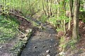
The Varresbeck Brook

The owl head path

Haus Richter, In der Beek

The owl head path

The owl head path

Lime funnel furnace

Lime funnel furnace

Lime funnel furnace

Lime funnel furnace

Lime funnel furnace

Lime funnel furnace


Nützenberg

Today's Nützenberg district consists on the one hand of the western outermost suburb of Elberfeld, the so-called Westende , which was industrialized in the 19th century, and on the other hand of the actual Nützenberg on the slope of the mountain of the same name (259 m). On the top of the mountain, the so-called Kaiserhöhe, a park was created in the 19th century, around which a residential area was formed after the war, which is characterized by single-family houses. From the industry in the valley, the original headquarters of Bayer AG has essentially been preserved, which also extends to the opposite bank of the Wupper in the Zoo district.
Attractions
- Weyerbuschturm
- Catholic Church of Saint Joseph
- Vogelsauer stairs
Brilliant district
.jpg)
The Briller quarter on the slope of the Nützenberg is one of the largest preserved Wilhelminian style villa quarters in Germany and is considered to be an upscale residential address in the city. It has a largely closed structure from the turn of the century and numerous listed buildings. New buildings in the quarter are mostly due to the division of land in the post-war period and have led to a greater density of buildings. This process continues. In the late nineteenth and early twentieth centuries, the Briller district was laid out as an upper-class residential area. Since the narrow valley area of the Wupper in the city of Elberfeld did not offer sufficient space and was also polluted by industrial exhaust fumes, the facility turned to the steeply rising slopes. The quarter is characterized by elaborate detached villas and richly designed row houses. The stylistic diversity of the buildings is great and ranges from late and neo-classicism to neo-gothic, neo-renaissance and neo-baroque to art nouveau and local style in the Bergisch style. Quotations of styles from different epochs are often combined in an eclectic manner on one building. Else Lasker-Schüler and Hans Knappertsbusch , among others, grew up in this quarter . Johannes Rau lived here during his time as Prime Minister of North Rhine-Westphalia. The Wuppertal Kurrende is based in the Briller quarter .
Arrenberg
In the 14th century, an Arrenberg farm was first mentioned in history. In the 19th century, Arrenberg was an industrial suburb west of Elberfeld, on whose grounds there were numerous factories. Arrenberg is still bounded to the west by the Bayer premises . Today it is a multicultural district with a considerable proportion of well-preserved buildings from the Wilhelminian era. The former municipal clinic Arrenberg, today part of the HELIOS clinic Wuppertal, is located on the Arrenberg . Since 1998, the Mediapark Wuppertal has been built on the site of a former slaughterhouse , a site on which more and more companies from the event catering and media industry are settling.
zoo
Zoo district


The zoo district was created in the second half of the 19th century on the " Am Kothen " site (not to be confused with the area of the same name in the north of Barmen ). Originally, the area on the western slope of the Kiesberg only housed a few farms and was owned by a few Wuppertal families. In 1879 the stock corporation Zoologischer Garten was founded and acquired the southern part of the area where the Wuppertal Zoo was inaugurated in 1881 . The Zoologischer Garten train station was created and the first road connection to the zoo was built from it. North of the zoo, an upscale city district was planned by the Hermanns & Riemann company . The city planner Josef Stübben had a considerable influence on the layout of the streets, regardless of the height differences, a neo-baroque street system was laid out, some of which has considerable inclines in individual streets. In the 1890s streets and the first villas were gradually laid out. In 1897 the fairy tale fountain by the sculptor Wilhelm Albermann was set up on a roundabout . In 1900 a decision was made to build a school because the Sonnborn school no longer had enough space for the children from the zoo. The zoo district is still an upscale residential area today, and many of the villas are listed. In 1924 the listed stadium at the zoo was built on the banks of the Wupper west of the zoo.
Misery and home
The "Elendstal" (the name only originated in the 19th century) to the east of the zoo quarter were only mud and wooden huts for the poor. Johanna Faust began missionary work in the area in 1868 and achieved that a chapel could be built. In 1872 a restaurant was built on the Königshöhe above. As a result, the Elendstal gradually became a festival site for numerous Christian associations and more and more a local recreation area. In 1892 a lookout tower was opened near the top of the Kiesberg with the Von-der-Heydt Tower . Below the valley, the non-profit building association "Heimat", the housing association of the employees' union, built the Heimatplan settlement in 1927–1930 . It crosses the park home plan .
Boltenberg
The residential area Boltenberg , located south of Sonnborn on the slope, is an upscale residential area. At the upper end of the quarter, near the turning loop of bus line 639, is the center for control and safety technology of Deutsche Bahn AG, a teaching and training center with an attached guest house with hotel character.
Buchenhofen
The Buchenhofen district essentially consists of the former farms of Rutenbeck on the stream of the same name (left the Wupper) and Buchenhofen (right the Wupper ). It houses only 63 residents. There are two sewage treatment plants in the neighborhood of the Wupperfeld, including the 1949 built large sewage treatment plant of Wupperverbandes that 1976-77 was used to fully biological system and a system for sludge dewatering and combustion received.
See also
literature
- Markus Arndt: The zoo district in Wuppertal as an example of the planning and development of a Wilhelminian style villa district. Dissertation, Bergische Universität / GHS Wuppertal, Sprockhövel 1999, ( online ).
- Herbert Günther: The west of the Elberfeld. Sutton, Erfurt 2007, ISBN 978-3-86680-095-3 .
- Axel Kirchhoff: The architect Heinrich Plange 1857–1942. A builder of entrepreneurship in the Bergisch region ( = contributions of the research center for architectural history, monument preservation and industrial culture of the Bergische Universität Wuppertal. Vol. 16). Müller + Busmann, Wuppertal 2010, ISBN 978-3-928766-93-7 (also: Wuppertal, Bergische Universität, dissertation, 2004).
- Hermann J. Mahlberg , Hella Nussbaum (ed.): The zoo district in Wuppertal. Thiergarten, stadium and picturesque living around the fairytale fountain. Müller and Busmann, Wuppertal 2004, ISBN 3-928766-63-5 .
- Hermann J. Mahlberg, Hella Nussbaum (Ed.): The departure around 1900 and the modern age in the architecture of the Wuppertal. Afterglow of an era (= contributions from the Research Center for Architectural History, Monument Preservation and Industrial Culture of the Bergische Universität Wuppertal. Vol. 15). Müller + Busmann, Wuppertal 2008, ISBN 978-3-928766-87-6 .
