Uellendahl-Katernberg
|
Uellendahl-Katernberg (2) District of Wuppertal |
|||||||||||||
|---|---|---|---|---|---|---|---|---|---|---|---|---|---|
| Coordinates | 51 ° 16 '50 " N , 7 ° 7' 25" E | ||||||||||||
| height | 189– 302 m above sea level NHN | ||||||||||||
| surface | 25.91 km² | ||||||||||||
| Residents | 37,067 (Dec. 31, 2014) | ||||||||||||
| Population density | 1431 inhabitants / km² | ||||||||||||
| Proportion of foreigners | 7.3% (Dec. 31, 2014) | ||||||||||||
| prefix | 0202 | ||||||||||||
| politics | |||||||||||||
| Allocation of seats (district representation) | |||||||||||||
|
|||||||||||||
| Transport links | |||||||||||||
| Highway |
|
||||||||||||
| Train | S 9 | ||||||||||||
| Source: Wuppertal statistics - spatial data | |||||||||||||
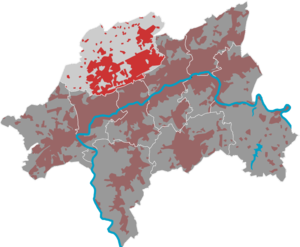
Uellendahl-Katernberg [ ˈuːlən- ] is a district of Wuppertal and belongs to its largest district, Elberfeld , which also includes the districts of Elberfeld and Elberfeld-West . Uellendahl-Katernberg is a district artificially created from the northern suburbs or incorporations of the old town of Elberfeld, the parts of which have no common historical roots.
geography
Division in the district
|
Uellendahl
Uellendahl is located north of a ridge ( Uellendahler Berg and Stübchensberg ) that separates the valley of the Mirker Bach from the Wuppertal city center, and extends north up the slope to today's Westfalenweg, which forms the watershed between the Ruhr and Wupper . The settlement of Uellendahl began around 1400. The poorly productive soil forced the rural residents of the initially only three farms to look for a sideline at an early stage. The yarn bleaching department came to their aid from the middle of the 15th century . Yarn processing later developed from this, which was practiced in the Uellendahl, especially as in-house knitting, until the recent past. With the establishment of some industrial companies and the associated increase in population around 100 years ago, residential development began, initially only slowly, which was intensified and completed in the last post-war period.
In the south of Uellendahl, on the border with Elberfelder Nordstadt, there is the Mirke , a loosely built-up area that is the Mirker station on the Düsseldorf-Derendorf – Dortmund Süd railway line ("Wuppertaler Nordbahn"), which is, however, in the Elberfelder Nordstadt Names. Coming from the Mirker Hain , a small forest area, the Eschenbeek stream flows into the Mirker Bach , which is of course already built over here.
Attractions
- Jewish cemetery on the vineyard
- Catholic St. Michaels Church (1958–1960)
- Lutheran St. Luke Church (1928)
- Teschemacher Hof (1671) in the Mirke, seat of the Elberfeld Teschemacher family, who provided numerous Elberfeld mayors and from whom the organ builder Jacob Engelbert Teschemacher came.
- Villa Seyd (1886)
Donberg
Dönberg is located on an elevation up to 300 m high north of Uellendahl. Dönberg was first mentioned in 1355. At that time, Dönberg belonged to the lordship of Hardenberg .
In modern times it was part of the Hardenberg community, which was renamed Neviges in 1935 . In 1846 a Protestant and in 1865 the Catholic parish church of St. Maria-Hilf was built. Since the sixties the place grew rapidly as a residential area. In 1985 the Catholic Church had to be torn down due to a fungus attack and replaced by a larger new building. With the territorial reform of January 1, 1975, Dönberg was incorporated into Wuppertal with Obensiebeneick and has since been part of the Uellendahl-Katernberg district. Even after the incorporation, the district has retained its rural character and a certain independence.
Dönberg has a size of 6.39 km², on which almost 5,000 people live. A special feature is the low unemployment rate of only 1.27%.
Katernberg
Similar to Uellendahl, Katernberg spread, especially in the 19th century, in the upper valley of the Briller Bach along the old Nevigeser Chaussee (today Nevigeser Straße ). Today Katernberg forms the districts Nevigeser Straße, Beek and Eckbusch. It surrounds the 240 m high Hasenberg in the west with the areas of Hülsbeck and Am Luhnberg and to the east of the brook it contains the basin Im Lehmbruch , Kuckelsberg , Amschlag , Am neue Hessen and Am Bredtchen , which rises to almost 300 m. The settlement of the valley of the brook Beek further to the west with the residential areas Bergerheide and Falkenberg dates mainly from the second half of the 20th century.
Attractions
Siebeneick
Siebeneick , actually Obensiebeneick (in contrast to Untensiebeneick, which belongs to Neviges ), is a rural area that came to Wuppertal with the regional reform in 1975. A residential area from the second half of the 20th century on Vogelsbruch on the border with Katernberg accommodates most of the around 2,500 residents of the quarter.
The Unterrohleder farm belongs to Siebeneick and houses two of the oldest half-timbered houses in Wuppertal from the 17th century. Other farms are Asbruch, Fingscheidt and Ibach.


