
Briller brook
| Briller brook | ||
 Briller Bach on the Luhnberg |
||
| Data | ||
| Water code | DE : 27365152 | |
| location | Wuppertal , North Rhine-Westphalia , Germany | |
| River system | Rhine | |
| Drain over | Wupper → Rhine → North Sea | |
| source | In Uellendahl-Katernberg 51 ° 16 '45 " N , 7 ° 7' 27" E |
|
| Source height | 255 m above sea level NN | |
| muzzle | At Robert-Daum-Platz in Wuppertal coordinates: 51 ° 15 '9 " N , 7 ° 8' 3" E 51 ° 15 '9 " N , 7 ° 8' 3" E |
|
| Mouth height | approx. 140 m above sea level NN | |
| Height difference | approx. 115 m | |
| Bottom slope | approx. 33 ‰ | |
| length | 3.5 km | |
|
Tributaries and hydraulic structures
|
||||||||||||||||||||||||||||||||||||||||||||||||||||||
The Briller Bach is a 3.48 kilometer long brook in the Wuppertal districts of Elberfeld-West and Uellendahl-Katernberg . The brook, which is a tributary of the Wupper , is also the namesake for the Brill residential area .
The water is shown on the Topographia Ducatus Montani map from 1715. Erich Philipp Ploennies labels it [in its entirety] in his created map with Hülsbec , 'bec' comes from ndt. Beek 'Bach'.
topography
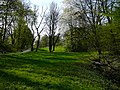
The stream rises near a residential area and near the northern end of the main road Nevigeser Straße at a height of 263 m. The first stretch of the stream runs around 500 meters above ground in a small natural area and leads south along the Nevigeser Straße . With the wet meadow by the stream and the large meadows with a playground, which is equipped with a half pipe , a park-like recreational area has been created here with the paved path .
The Briller Bach has formed a small valley in the slate, which the road follows. In the further course, the stream is piped and continues underground. He follows the further course of Nevigeser Straße , Boschstraße and Kruppstraße and then passes under the federal motorway 46 .
Now the brook follows the further course of Briller Straße further south , which got its name from the brook. At the same time, this main street is the eastern limit to the Briller Viertel , which is on the eastern slope of the Nützenberg , and the western limit of the Mount of Olives . The brook continues at the level of Katernberger Straße until it flows into the Wupper at 148 meters above sea level. The confluence is after crossing under the federal highway 7 near the suspension railway station Robert-Daum-Platz .

Small bridge

Wet meadow

Flora by the stream
From here it continues underground


Individual evidence
- ^ German basic map 1: 5000
- ↑ Topographic map 1: 25,000
- ↑ River Area Geoinformation System of the Wupper Association (FluGGS Wupper)
- ^ Wolfgang Stock: Wuppertal street names. Their origin and meaning. Thales Verlag, Essen-Werden 2002, ISBN 3-88908-481-8 .