
Nützenberg
| Nützenberg | ||
|---|---|---|
 In the background the Nützenberg, seen from the northeast |
||
| height | 259.3 m | |
| location | Wuppertal | |
| Mountains | Rhenish Slate Mountains | |
| Coordinates | 51 ° 15 '17 " N , 7 ° 7' 13" E | |
|
||
 The surveys in Wuppertal |
||

The Nützenberg is a 259.3 meter high elevation in the west of the city of Wuppertal and at the same time namesake of the Nützenberg residential area .
topology
It is located in the Elberfeld-West district between the two districts of Elberfeld and Vohwinkel . The almost 260 meter high mountain is located north of the Wupper and the federal highway 7 (B 7) running parallel to it , the suspension railway line and the Elberfeld – Dortmund railway line through Wuppertal . In the west and north is the route of the federal motorway 46 (A 46) running here , further north is the Falkenberg .
The summit of the 282-meter-high Kiesberg is only 450 meters south as the crow flies . One of the narrowest parts of the Wupper valley is located here. Together with the Kiesberg, the Nützenberg forms the natural spatial unit of the Nützenberger Querriegel (order number 337 1 .36).
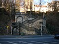
On the side facing the Wupper there are caves that were used as bunkers during the Second World War . But they are not open to the public today.
Development
The slopes of the Nützenberg are mostly built up quite densely, so the topography allows. The upscale residential area of the Briller Quarter is located on the eastern side of the mountain .
On the southern flank, the Wilhelminian-style houses rise up on Nützenberger Strasse. To the west are both single-family and high-rise buildings from the 1960s and 1970s. The northern side of the mountain is also covered with residential buildings that extend further north over the route of the A 46 running here. The former Federal President Johannes Rau lived there in the north for years before he became Federal President.
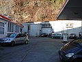
Bayer AG's production facilities are located in the southern Wupper valley .
use
The undeveloped and tree-lined summit, the Nützenbergpark , is designed like a park and has numerous hiking trails, so that it is a local recreation area in the west of Elberfeld. Here you will find a sports field, a playground and a high ropes course.
Buildings

The Weyerbuschturm , an observation tower that can be climbed on certain days in the summer months, is practically on the highest elevation .
From the southern Wupper valley, the mountain can be climbed on the Vogelsauer and Nützenberger stairs . Both stairways are very long open staircases in the city of Wuppertal, which is not poor due to the topography of stairs. Overall, they overcome a difference in altitude of a good 80 meters. Further east is still the Jacob stairs .
gallery

Steep rock slopes on the southern flank
Bunker systems
Vogelsauer stairs

Unusual residential construction in the 1970s, only recognizable as two-story houses on the upper street. Is a 12-storey terrace house from the valley.


