Heckinghausen (city district)
|
Heckinghausen (7) district of Wuppertal |
|||||||||||||||
|---|---|---|---|---|---|---|---|---|---|---|---|---|---|---|---|
| Coordinates | 51 ° 16 ′ 13 ″ N , 7 ° 13 ′ 17 ″ E | ||||||||||||||
| height | 160– 321 m above sea level NHN | ||||||||||||||
| surface | 5.66 km² | ||||||||||||||
| Residents | 21,193 (Dec. 31, 2014) | ||||||||||||||
| Population density | 3744 inhabitants / km² | ||||||||||||||
| Proportion of foreigners | 17.3% (Dec. 31, 2014) | ||||||||||||||
| prefix | 0202 | ||||||||||||||
| politics | |||||||||||||||
| Allocation of seats (district representation) | |||||||||||||||
|
|||||||||||||||
| Transport links | |||||||||||||||
| Federal road |
|
||||||||||||||
| Local transport | Suspension railway | ||||||||||||||
| Source: Wuppertal statistics - spatial data | |||||||||||||||
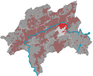
Heckinghausen is the smallest district of Wuppertal . Until 1929, part of what is now the city district was a separate part of the city of Barmen . The city district, to which the northern part of the former city of Ronsdorf around Hammesberg and Konradswüsten was added, also includes the localities Clef , Heckinghausen , Heidt , Norrenberg , Plückersburch , Gosenburg and Bockmühle .
geography
Division in the district
|

|
Etymology and history
Since the district of Heckinghausen serves purely statistical purposes and artificially combines several independently grown districts, see the articles of the individual districts and residential quarters, especially those of the core area Heckinghausen , for the etymology and history of Heckinghausen .
Attractions
- Half-timbered house from 1608 in Spiekerstraße
- Old customs bridge over the Wupper from 1775
- Luther Church on Heidt
- Heckinghausen gas tank from 1950
See also: List of architectural monuments in the Wuppertal district of Heckinghausen


