Barmen (municipality)
|
Barmen (5) district of Wuppertal |
|||||||||||||||
|---|---|---|---|---|---|---|---|---|---|---|---|---|---|---|---|
| Coordinates | 51 ° 16 '10 " N , 7 ° 11' 30" E | ||||||||||||||
| height | 148- 350 m above sea level. NHN | ||||||||||||||
| surface | 15.44 km² | ||||||||||||||
| Residents | 58,919 (Dec. 31, 2013) | ||||||||||||||
| Population density | 3816 inhabitants / km² | ||||||||||||||
| Proportion of foreigners | 16.9% (Dec. 31, 2013) | ||||||||||||||
| prefix | 0202 | ||||||||||||||
| politics | |||||||||||||||
| Allocation of seats (district representation) | |||||||||||||||
|
|||||||||||||||
| Transport links | |||||||||||||||
| Highway |
|
||||||||||||||
| Federal road |
|
||||||||||||||
| railroad | RE 4 RE 13 RB 48 | ||||||||||||||
| Train | S 7 S 8 | ||||||||||||||
| Local transport | Suspension railway | ||||||||||||||
| Source: Wuppertal statistics - spatial data | |||||||||||||||
Barmen is one of the ten districts of Wuppertal . It used to form together with today's districts of Heckinghausen , Oberbarmen and parts of Langerfeld-Beyenburg the city of Barmen , which in 1929 was combined with Elberfeld and some other cities and communities to form today's Wuppertal.
geography
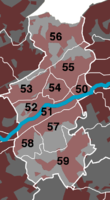
The area of the district of Barmen corresponds to the old western town center of Barmen, "Gemarke" (today the district "Barmen-Mitte" on the eastern border of the district) and the western suburb, which is known as " Unterbarmen ". The quarter on the Sedansberg was largely created at the beginning of the 20th century as a northern workers' suburb. In the south, the area extends to the Lichtscheid , which at 350 m is the highest elevation in Wuppertal and belonged to Ronsdorf before 1929 .
Division into quarters
|

|
history
As a purely statistical administrative district, the city district of Barmen is only part of the former city of Barmen. For the history of Barmen see the main article Barmen , for the history and descriptions of individual locations see the respective neighborhood articles .
Attractions
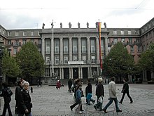
The main representative buildings of the city are located in the district of Barmen, such as the Wuppertal town hall , the Barmer train station and the “ Hall of Fame ”, today's “House of Youth”. In addition, the historical center with the museum for early industrialization, the birthplace of Friedrich Engels senior, as well as the Theater am Engelsgarten and the opera house of the Wuppertaler Bühnen are located in the city district . Barmen also has a pedestrian zone with specialty shops.
Based on the parish of the Gemarker Church , the Barmen Theological Declaration was adopted as the theological foundation of the Confessing Church with the first Barmen Confessing Synod from May 29 to 31, 1934 , in order to oppose the influence of the National Socialists on the Church. The Bergische Synagoge , the new building for the Jewish community in Wuppertal, is located on the same site today .
traffic
Street
Barmen can be reached via the Wuppertal-Barmen junction on the A 46 and Wuppertal-Langerfeld on the A 1 . In addition, the B 7 runs through Barmen .
Rail transport
The Wuppertal-Barmen station is on the Elberfeld – Dortmund railway line . In regional traffic it is served by all regional trains that run through Wuppertal (except Rhein-Münsterland-Express RE7) as well as the S-Bahn lines S 7 and S 8.
Transportation
The most important stop in Barmens is the Alter Markt suspension railway station , which is a large bus node with a link to the Wuppertal suspension railway .


