
Lichtscheid
| Lichtscheid | ||
|---|---|---|
 Lichtscheid with the water tower, high-flyer of the L419, the former barracks area of the Colmar barracks, hardware stores and Vorwerk Autotec factory buildings |
||
| height | 350 m above sea level NHN | |
| location | Wuppertal , North Rhine-Westphalia , Germany | |
| Mountains | Rhenish Slate Mountains | |
| Coordinates | 51 ° 14 '36 " N , 7 ° 11' 23" E | |
|
||
 The surveys in Wuppertal |
||

Lichtscheid is 350 m above sea level. NHN is the highest point in the city of Wuppertal and belongs to the Lichtenplatz residential area . The location emerged from a medieval courtyard .
Topography, location and transport links
Lichtscheid lies on the ridge of the Wuppertal southern heights and is 350 m above sea level. NHN represents the highest elevation in the city. It is not a prominent mountain, but rather an inconspicuous elevation on the ridge, which initially slopes gently to the west and east. In a northerly direction there is a significantly more pronounced gradient into the Wupper valley to the districts of Elberfeld and Barmen . The Ronsdorf district begins on the less steep southern slope with the rural outskirts of the Ronsdorf-Mitte / Nord residential area . The altitude allows a view of the likewise high-lying center of the neighboring town of Remscheid .
The Wuppertal districts of Elberfeld , Barmen and Ronsdorf , all independent towns before 1929, border on Lichtscheid . The sources of the Bendahler Bach and Gelpe are also located here . The latter, a tributary of the Morsbach , gives the historic Gelpe valley its name. The Kothener Bach , the Auer Bach , the Murmelbach and the Schmalenhofer Bach arise in the wider area of the height .
Landesstraßen 417 ( Lichtscheider Strasse , the extension of Ronsdorfer Strasse ), 418 and 419 ( Obere-Lichtenplatzer-Strasse and Oberbergische Strasse ) as well as Kreisstrasse 21 (also Oberbergische Strasse ) also meet on the Lichtscheid at an elaborately constructed traffic junction with a roundabout and High flyers together.
Buildings
The Lichtscheider water tower built on Lichtscheid , which is located in the center of the traffic junction, is striking . The old Lichtscheider water tower , which formerly stood 200 meters north of this at the highest point in the urban area, was blown up after the new building was commissioned in 1977. The old Ronsdorf water tower , which stood a kilometer to the southeast, was also torn down.
In addition, there is a location for the headquarters of the health insurance company Barmer GEK , a former barracks , two hardware stores, the administration of the companies "Vorwerk Drivetec" and "Vorwerk Autotec" and a brick building in a former substation that has been converted into a fitness studio . Nearby is the Bergische Sonne leisure pool, which was closed in 2012, and a little further away is the Müngstener Straße property on the site of the former Barmer Stadium opposite the Lichtenplatzer chapel , where the riot police and other departments of the Wuppertal police station and a car workshop of the LZPD NRW are located.
The extensive factory buildings of the companies "Vorwerk Drivetec" and "Vorwerk Autotec" have been largely demolished in recent years to make room for a hardware store . Most recently, they served, among other things, as space for the Technology Center in Wuppertal , which moved to Lise-Meitner-Strasse in 2003. The residential development on the opposite side of Oberbergische Strasse was also demolished in the middle of the first decade of the 21st century and a hardware store and a discount market were built on. The Colmar barracks , which are no longer in use, were converted into a technology park and a new housing estate from the end of 2008, while preserving some of the historic buildings .
history
The farms on Lichtscheid were first mentioned in a document in 1466 in a Beyenburg official invoice from the Beyenburg rentmaster . At that time, the three courtyards Wilhelms Lichtenscheid , Peters Lichtenscheid , Gockelsheid (the later locality Heide ) and the Kotten Schafferts Kothe existed there . Other nearby courtyards at this time were Buer ( Baur ) and Capell ( chapels ). In the Middle Ages, Baur had to pay taxes to the Steinhaus monastery and it is assumed that there was a chapel for the monastic courtiers in the neighboring chapel . The presumption is derived exclusively from the name of the farm, there is no documentary evidence of this. To the east of Lichtscheid was the neighboring Marpe farm .
The area belonged to the Elberfeld parish in the Beyenburg district until its own parish was founded in Barmen . The place was recorded as Leitschüt in 1715 in the map series Topographia Ducatus Montani by Erich Philipp Ploennies . The Gockelsheid (e) farm is also still listed in 1715, as is a farm grauleitschütt (later Lichtenplatz ) to the east of it. The Marpe farm near Ploennies is already listed as a village without a church , i.e. as a hamlet .
On today's Schliemannweg , in 1789, on the map of the Duchy of Berg by Carl Friedrich von Wiebeking, a Kölschejan residential area is recorded, which is also called that on the topographical survey of the Rhineland from 1824. The Lichtenplatz residential area , which will later give the entire Wuppertal residential area its name, is located to the north of Gockelsheid (e)
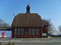
Loose housing development along the main roads did not emerge until the 18th century. In 1789 the Marper School was built near Lichtenplatz , the second oldest school building in what is now the Wuppertal. The school is now used as a primary school. In 1904 the evangelical Lichtenplatz chapel was built next to the school house . On the city limits of Ronsdorf, the park at the Jägerhof restaurant with its high observation tower was a popular attraction on Lichtscheid at the end of the 19th century .
The large building was built at the turn of the 20th century with the establishment of Vorwerk'schen factory and the development of light Scheids to an intersection of Unter Barmen Ronsdorf, today Oberbergische Road ( County Road 21 / State Road 419 ) and the road Barmen Cronenberg or Elberfeld , today's Obere Lichtenplatzer Straße ( Landesstraße 418 ) or today's Lichtscheider Straße / Ronsdorfer Straße (Landesstraße 417). There the tracks of the tram line 23 from Elberfeld to Ronsdorf met the route of the Ronsdorf-Müngstener railway , from which a siding led to the Vorwerk factory. In 1902/03, the 44.4 meter high old Lichtscheider water tower was built on the highest point to provide drinking water in Barmer . The Barmer Stadium was built in 1909, and its cycling track enjoyed great popularity. The inn " Beautiful View " or " sports restaurant Finkenstein " ( Obergische street corner Böhler way ) near the stadium was a popular tourist cafe that time. To the east of the stadium, a police station shelter was built in the 1920s .
In chapels a first Wagenhalle for the tram was built in the 1920s, which in subsequent years to a depot with several halls, including depot was expanded. A major change in the landscape resulted from the construction of the Colmar barracks from 1936, during which the settlement areas heather and oak were built over. The agriculturally used land Scharpenacken east of Lichtscheid was as a training area rezoned, the local farms were over the coming decades to deserted villages . The Vorwerk factory had also expanded considerably by then and now took up the entire area between the intersection and the Barmer stadium. The construction of the temporary Catholic church at the foot of the water tower and the construction of the substation also fall during this period.
After the Second World War , a barracks settlement for bombed-out citizens was built on the water tower . The Ronsdorf water tower, which was badly damaged by a bomb hit in 1943, was demolished. The Barmer Stadium was closed due to war damage in the 1950s, the police barracks were now used as accommodation and training facility for the riot police. The British army stationed units in the Colmar barracks until the property was handed over to the German armed forces in 1968 . A new residential development with single and multi-family houses was built along Scharpenacker Weg and Adolf-Vorwerk-Straße . The Catholic Church of St. Christophorus on Schliemannweg was built in 1955, and the old provisional church by the water tower was demolished a few years later. Years before the last tram line in Wuppertal was closed in 1986, there were no longer any trams passing through Lichtscheid. The Ronsdorf-Müngstener Eisenbahn ceased operations on this section as early as 1959.
Lichtscheid underwent extensive changes with the expansion of state roads 417, 418 and 419, with the expansion of the L418 / L419 to four lanes and the construction of a plan-free high-flyer instead of the intersection having an impact. The other main roads were connected to this main traffic axis by means of a large roundabout below the high- flyer. On December 2, 1977, the old Lichtscheider water tower was blown up amid public protests; its task was taken over by a previously constructed new building between the two bridges of the high-flyer, the Lichtscheider water tower . All the buildings of Hofschaft Lichtscheid that were still preserved fell victim to road construction at that time.
In the 1980s, the tram depot at Kapellen was first used as a bus depot for the Wuppertal municipal utilities , then a private bus operator and later as a timber shop. After a fire it stood empty and was demolished before 1992 for the construction of the Bergische Sonne leisure pool . Opposite was the new headquarters of the former Barmer Ersatzkasse , and a data center was added to the east in the mid-1990s. The Vorwerk factory shrank steadily and made space for the hardware store and the technology center.
After 1993, parts of the Colmar barracks were used for asylum seekers, resettlers and the riot police. Other parts were merged with the neighboring Diedenhofen barracks (new Generaloberst Hoepner barracks). The site is also being developed together with that of the Diedenhofen barracks. By the end of 2008, the wagon halls of the barracks on Scharpenacker Weg were demolished in order to make space for new residential developments. Several team buildings facing Oberbergische Strasse were preserved.

The Lichtscheider water tower
The evangelical chapel in Lichtenplatz

Headquarters of the former BARMER replacement cash desk on Lichtscheid


literature
- Michael Wiescher : Farmers, weavers, workers - On the history of the southern heights in Barmen , Verlag H.-J. Momberger, Wuppertal 2014, ISBN 978-3-940439-60-4

Allenkotten | Auer Höfe | Barendahl | Eckbrock / beer oaks | Post mill | Bredde | Brügeler Höfe | Brucher Höfe and Kotten | Carnaper Höfe | Clauhausener Höfe | Clever Höfe | Dahl | In the thick | Dörner Hof (Barmen House) | Fat hen | Fingscheid | Courtyard to the ford | Gockelsheide | Before the Hardt | Hatzfeld | Heckinghauser Höfe | Heidter Kotten | Chapels | Kamp | Kemna | Klinkholt | To the Kotten | Krühbusch | Lattmorgen | Leimbacher Höfe and Kotten | Lichtenscheider Höfe | Loher Hof | In the Marpen | Nickhorn | Norrenberg | Rauental | Rauenwerth | Riescheider Höfe | Rittershof | Schimmelsburg | Schlipperhof | Schönebeck | Stoke | Scheuermannshof | Schwaffers Kotten | Sehlhof | In jumping | Werther Hof | West | Westkotter Höfe | Wichlinghauser Höfe | Winkelmannshof | Wülfinger Hof | Wuppermanns Höfe