Scheuren (Wuppertal)
|
Shame
City of Wuppertal
Coordinates: 51 ° 16 ′ 28 " N , 7 ° 12 ′ 11" E
|
||
|---|---|---|
| Height : | 160 m above sea level NHN | |
| Area code : | 0202 | |
|
Location of Scheuren in Wuppertal |
||
Schüren , Schueren and earlier also called Scheuren , was a locality in the Bergisch town of Barmen , (today part of Wuppertal ). The local situation emerged from one of the medieval courtyards of Barmen.
Location and description
The Schüren district lies between Bredde and Bachstrasse in the east, Westkotter Strasse and Wuppermannstrasse in the north, and the Heubruch in the west. In the south the area is limited by the course of the mill ditch . The district emerged from the former Scheuren farm, which was roughly at the point where Bredde, Bachstrasse, Mühlenweg and Westkotter Strasse intersect today. Today only the road to Scheuren points to the former farm.
The district of Schüren is primarily a residential area. The development consists mainly of modern rental buildings, as the district was largely destroyed in the bombing of Barmen . Only a few of the classic half-timbered houses , such as the Hösterey house on Mühlenweg, have been preserved. The only larger industrial facility is the Vorwerk administration building ; the original production facilities were largely demolished in the post-war years. The former Lutheran Church of Peace was on the border with the district of Gemarke (today Barmen-Mitte ), where the new town hall building stands today. The church was destroyed in World War II and the ruins were later demolished. Only the associated community home, which was inaugurated in 1914, is still standing on Mühlenweg.
The former Old Synagogue in Barmen , which was burned down during the night of the pogrom in 1938 , was also located on Scheuren ; 1998–2002 the new Bergische Synagoge was built on a piece of land behind the Gemarker church. The location of the old synagogue is marked by a plaque.
history

The former Scheuren farm was probably a split off from the former Westkotten estate . Today's Westkotter Straße was the path that connected Westkotten with its former barns on the meadows of the Wupper Valley. These barns formed the origin of the farm that was first mentioned in the Beyenburger official account of 1466. The original farm encompassed an area of about 70 acres that included meadows, farmland and woodland.
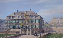
The location of the farm was very favorable: In the north the Wichelhausberg belonged to the farm area; in the south, meadows stretched to the Mühlengraben , which marked the border with the Werther Hof . The meadows were irrigated directly from the Mühlengraben and therefore offered excellent conditions for yarn bleaching. At the beginning of the 17th century, the farm was divided by inheritance, and Obere Scheuren, located more to the east, fell to the Wuppermann family. Untere Scheuren, located more to the west, was taken over by the Wichelhaus family and later by the Beckmann family after some inheritance disputes. The local names Wichelhausberg and Beckmannshofstrasse still refer to these owners. Both the Wuppermann family and Beckmann (later Beeckmann) were wealthy bleachers and silk traders. With Haus Schüren, Johann Carl Wuppermann built a splendid residence and created a terrace garden behind the house on the Fatlohberg , which was a local attraction for decades.
Abraham Beeckmann from Beckmannshof built a bridge over the Mühlengraben at his own expense in the late 18th century. His aim was to improve the traffic connection to the district in order to better develop the Scheurens. He forgave several properties along the way to Barmer mill in long lease , there new houses were built, making the Mühlenweg developed as an important link between the Gemarke and Scheuren.
Reinhard Theodor Wuppermann , on the other hand, improved the traffic connection to the east by creating a path on his Bleichgrund, today's Bachstrasse, to Wupperfeld. For this he also built a bridge over the Mühlengraben. The old Beckmannshof was sold in 1818, served as a nursery for a while and was then demolished in the mid-19th century. The courtyard house stood on today's Beckmannshof between Mühlenweg and Große Flurstraße. Haus Schüren was sold in the middle of the 19th century and was later used as a shop and office. It was destroyed in the bombing raid on Barmen. The house stood exactly where Bredde, Bachstrasse, Mühlenweg, and Westkotter Strasse intersect today.
literature
- Walter Dietz: Barmen 500 years ago. An examination of the Beyenburger official accounts from 1466 and other sources on the early development of the place Barmen (= contributions to the history and local history of the Wuppertal. Vol. 12, ISSN 0522-6678 ). Born-Verlag, Wuppertal 1966.
- Walter Dietz: Chronicle of the Wuppermann family. = Wuppermann. 3 volumes. Family association of the Wuppermann family, Leverkusen-Schlebusch 1960–1967;
- Volume 1: Peasants, Bleachers and Merchants. 1960;
- Volume 2: Wuppermanns in home and world. 1965;
- Volume 3: Notes, Explanations and Sources, Register. 1967.
- Ernst Wuppermann: The house to stir up. Family association of the Wuppermann family, Leverkusen-Schlebusch 1938.
Individual evidence
- ↑ Friedensheim on barmen2008.de
- ^ Family Wuppermann
- ^ Johann Carl Wuppermann on barmen2008.de

