Hatzfeld (Wuppertal)
|
Hatzfeld (56) district of Wuppertal |
|
|---|---|
| Coordinates | 51 ° 17 '13 " N , 7 ° 10' 53" E |
| height | 285 m above sea level NHN |
| surface | 2.8 km² |
| Residents | 3922 (December 31, 2016) |
| Population density | 1401 inhabitants / km² |
| Proportion of foreigners | 8.0% (Dec. 31, 2016) |
| Post Code | 42281 |
| prefix | 02 02 |
| Borough | Barmen |
| Transport links | |
| bus | 583 627 635 637 644 NE3 |
| Source: Wuppertal statistics - spatial data | |
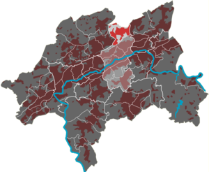
Hatzfeld is a district and residential area in the Wuppertal district of Barmen . The district emerged from one of the medieval Barmer original farms.
Location and description
The residential area is limited in the north by the city limits to Sprockhövel - Gennebreck , in the east by Märkische Strasse and in the south by the federal motorway 46 . The west is limited by the streets Am Westerbusch , Am Pannesbusch , Lockfinke , Lante and Hohenhagen .
Other locations and places to live in the residential area, some of which date from the Middle Ages, are Beesen , Dickten , Flanhard , Horather Schanze , Riescheid , Sauerholz , Siepen , Stütingsberg , Tente . Dahlkamp and Einerngraben are among the lost locations .
Etymology and history
The first traces of an estate organized Hirutfelde (position Hatzfelder street corner Uellendahler street ) are in the BECOMING lifting Register to find from the year 1070th This became Hertzfeld in 1466 and Hartsfield in 1597 . Hert is an older form for deer - Hatzfeld therefore means deer field .
According to the register, the court was obliged to pay 17 denarii. The next mention of Hatzfeld comes from the Beyenburger official account (account of the rent master to the Bergisch-ducal camera administration ) of the year 1466. From this it emerges that the residential area Hatzfeld was a Kotten , i.e. a smaller courtyard, at that time . A Nesa (Agnes) van dem Hertzfelde had to deliver two chickens.
The Barmer line of the Bergische Landwehr ran east of Hatzfeld . The territory around Hatzfeld was from 1324 to 1420 in the Brandenburg parish and Gogerichts district Schwelm and then passed to the Bergische Amt Beyenburg , where it was passed on to the Barmer farmers . It remained in the Schwelm parish until its own parish was founded.
1715 Hatzfeld is listed as Hazfeld on the Topographia Ducatus Montani by Erich Philipp Ploennies . With the other farms in the Barmen farming community , Hatzfeld was part of the Bergisches Amt Beyenburg until 1806.
The area on the Hatzfeld was only sparsely populated until the 19th century, a larger farm at the Horather Schanze on the northern border of the area with buildings partly from the 18th century has been preserved to this day, and there are other half-timbered houses from before 1800 in the southwest. At the beginning of the 20th century, the actual Hatzfeld was specifically intended for the northern expansion of the city of Barmen; the first companies were established in 1909. The development plan provided for space for industry and the associated workers' settlements, partly with workrooms for the residents for weaving or other craft activities. According to this first plan, the city of Barmen built the Hatzfeld housing estate in 1911–1912 . The original development plan was not pursued further except for the street layout. In 1926 the urban emergency settlement on the Brahm was built (1926); private housing was mainly built in 1925–1930 southwest of it. The Lotte-Neumann-Siedlung , a half-timbered settlement in the so-called Heimatschutzstil , was created on the initiative of a foundation in the years after 1935.
Today the area is characterized by the industrial site, which is now owned by the Axalta company . The landmark is the old Hatzfeld water tower , which should actually be put down when the new Hatzfeld water tower was built. The Loh – Hatzfeld railway was a five-kilometer branch line that ran from the Loh district to Hatzfeld.
Web links
Individual evidence
- ^ Wolfgang Stock: Wuppertal street names. Their origin and meaning. Thales Verlag, Essen-Werden 2002, ISBN 3-88908-481-8 .
- ↑ Christoph Heuter: City Creation . Settlements from the 1920s in Barmen (= contributions from the Research Center for Architectural History and Monument Preservation of the Bergische Universität Wuppertal. Vol. 6). Müller and Busmann, Wuppertal 1995, ISBN 3-928766-15-5 .


